Substation inspection robot mapping method based on GPS closed-loop detection

An inspection robot and closed-loop detection technology, applied in the field of intelligent robots, can solve problems such as difficulty in meeting the reliability requirements of robot positioning accuracy sets, huge data volume in substations, and inability to close ring roads, so as to improve positioning accuracy and reliability, improve The effect of building map efficiency and improving speed

Pending Publication Date: 2019-09-03
广东亿嘉和科技有限公司
View PDF28 Cites 13 Cited by
  • Summary
  • Abstract
  • Description
  • Claims
  • Application Information

AI Technical Summary

Problems solved by technology

[0004] (1) Using a single positioning sensor is difficult to meet the positioning accuracy and reliability requirements of the robot;
[0005] (2) There is a large cumulative error, which makes some ring roads unable to be closed;
[0006] (3) The amount of data in the substation mapping process is huge, and the mapping efficiency is low

Method used


Image

  • Substation inspection robot mapping method based on GPS closed-loop detection
  • Substation inspection robot mapping method based on GPS closed-loop detection
  • Substation inspection robot mapping method based on GPS closed-loop detection

Examples


Embodiment

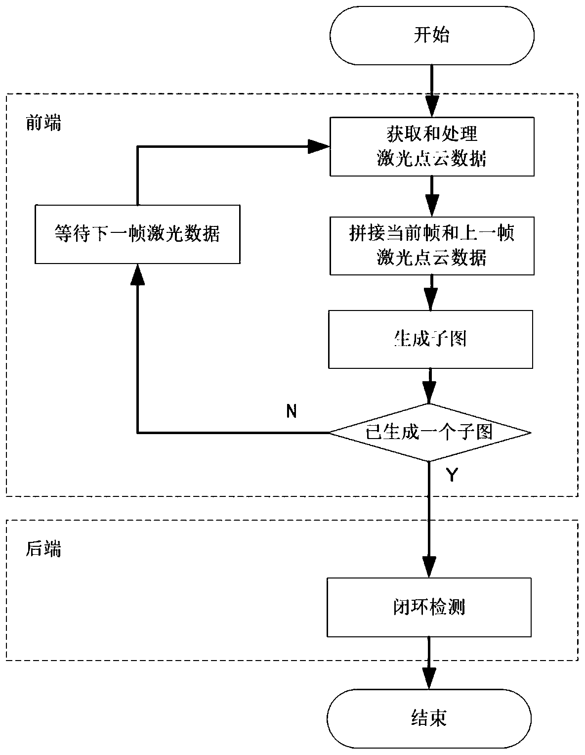
[0048] An embodiment of the present invention introduces a mapping method for substation inspection robots based on GPS closed-loop detection.

[0049] The robot that this embodiment adopts, its hardware system sensor mainly comprises odometer, inertial navigation unit, three-dimensional laser sensor, and wherein odometer can be used for the predicted value of calibration position, and inertial navigation unit can be used for calibration linear velocity, angular velocity, three-dimensional laser sensor. Sensors are used to obtain laser data. The robot software system uses the robot operating system ROS, which is a commonly used robot software platform. It can provide functions similar to operating systems for heterogeneous computer clusters, and the ROS system includes nodes that implement positioning functions. Of course, it can be understood that the method of the present invention can also be implemented by other robot software systems, and the ROS system is used in this em...


PUM


Abstract

The invention belongs to the technical field of intelligent robots, and discloses a substation inspection robot mapping method based on GPS closed-loop detection. The method comprises steps: the robotwalks according to a specified route, and laser point cloud data during walking are acquired; in a global coordinate system, by using the conversion relationship between poses in adjacent two framesof laser and the point cloud data of a former frame of laser, inter-frame laser point cloud data are spliced; tile-type mapping is carried out; a specified frame of a sub image is selected as a key frame; the current position of the robot is positioned in real time according to GPS data, and with the position as a circle center and the specified distance as a radius, a closed-loop candidate area is defined; and each candidate pose in each sub image in the closed-loop candidate area is screened, and when a certain pose meets a screening condition, the laser frame corresponding to the pose and the key frame are subjected to closed-loop connection. By adopting the substation inspection robot mapping method based on GPS closed-loop detection, the calculation amount related to positioning is greatly reduced, and the positioning efficiency and the positioning accuracy are significantly improved.

Description

technical field [0001] The invention belongs to the technical field of intelligent robots, and in particular relates to a mapping method for substation inspection robots based on GPS closed-loop detection. Background technique [0002] Substation mapping is a necessary link before the operation of the laser navigation substation robot. It mainly records the map of the substation in the form of data as detailed and accurate as possible. The laser navigation substation inspection robot uses the map to compare with the surrounding information obtained by the laser sensor in real time, and determines the position of the substation inspection robot through a positioning algorithm. Therefore, the accuracy of the substation map is very important for the navigation and positioning of the laser navigation substation robot. [0003] The two-dimensional laser mapping of the substation robot is a process in which the robot calculates its own position and builds an environmental map bas...

Claims


Application Information

Patent Timeline
Patent Type & Authority Applications(China)
IPC IPC(8): G01C21/00
CPCG01C21/005
Inventor 林欢张利平万杰
Owner 广东亿嘉和科技有限公司
Why Eureka
Try Eureka