Field crop three-dimensional reconstruction method based on laser radar point cloud

A laser radar and three-dimensional reconstruction technology, applied in the field of agricultural machinery intelligence, can solve the problem that the three-dimensional model of a single crop cannot provide sufficient data basis for field management, and achieve the effect of reducing labor costs and improving accuracy

Active Publication Date: 2019-10-22
NANJING FORESTRY UNIV
View PDF4 Cites 12 Cited by
  • Summary
  • Abstract
  • Description
  • Claims
  • Application Information

AI Technical Summary

Problems solved by technology

However, the 3D model of a single crop cannot provide sufficient data basis for field management

Method used


Image

  • Field crop three-dimensional reconstruction method based on laser radar point cloud
  • Field crop three-dimensional reconstruction method based on laser radar point cloud
  • Field crop three-dimensional reconstruction method based on laser radar point cloud

Examples


Embodiment Construction

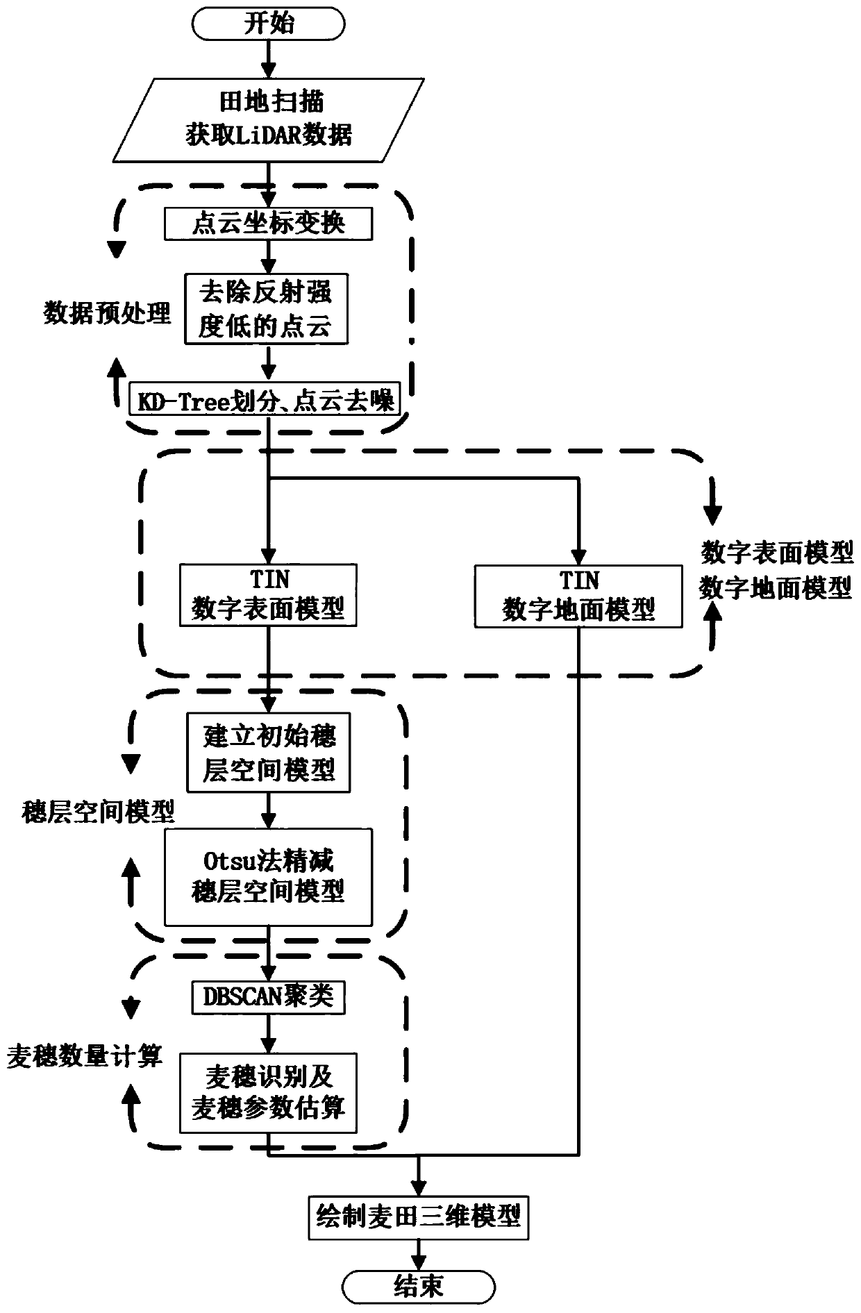
[0044] The following is based on Figure 1 to Figure 5 The specific embodiment of the present invention is further described:

[0045] The field crops of this embodiment take the wheat field as the object, and the method for reconstructing the three-dimensional model of the field wheat is as follows: figure 1 As shown, the details are as follows:

[0046] (1) Obtaining data and data preprocessing:

[0047] Control the UAV equipped with lidar to fly over the wheat field, scan the wheat with lidar to obtain point cloud data, and then perform data preprocessing.

[0048] The data preprocessing process of this embodiment is:

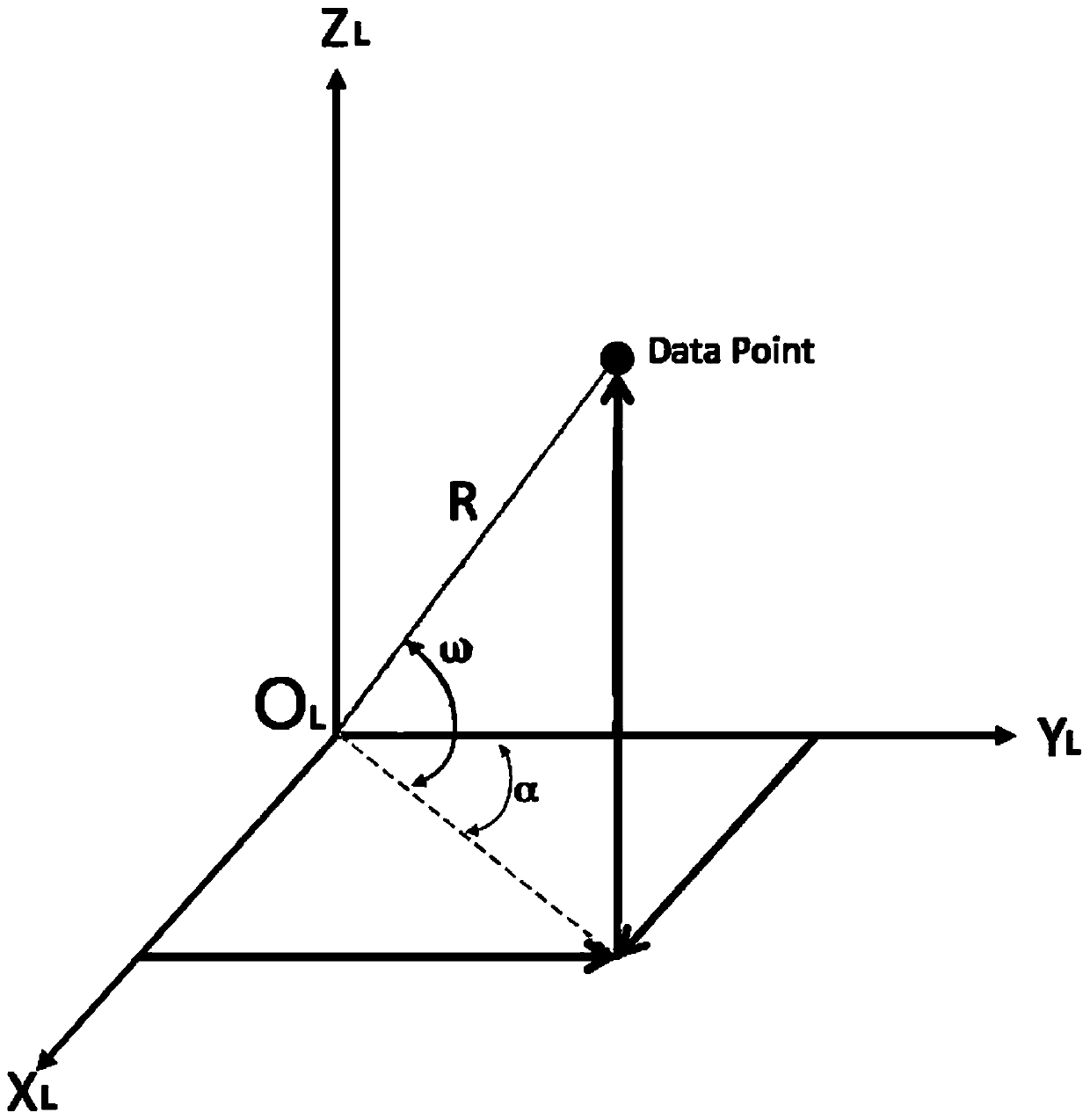
[0049] (1) Point cloud coordinate conversion:

[0050] (a) Establish the lidar coordinate system O L -X L Y L Z L and UAV coordinate system O V -X V Y V Z V . The radar coordinate system is represented by the subscript L, and the coordinate origin O L Located in the center of the radar's internal receiver, the X L is the front of the radar, Y ...


PUM


Abstract

The invention discloses a field crop three-dimensional reconstruction method based on laser radar point cloud, and the method comprises the steps: obtaining the point cloud data of a field crop through a laser radar, and carrying out the data preprocessing of the point cloud data; extracting a small amount of point clouds as key control points, and establishing a digital surface model and a digital ground model by utilizing the key control points and through an irregular triangulation network; constructing an initial spike layer space model according to the digital surface model, and obtainingpoint cloud data in an actual spike layer space model through an Otsu threshold method; segmenting the point cloud in the actual spike layer space model into a plurality of point cloud clusters by adopting a density-based clustering algorithm; correcting the number of point cloud clusters, the number of the point cloud clusters being the number of crop ears, and calculating the crop height according to a digital ground model; and constructing a three-dimensional model of the crops in the field according to the obtained crop number, crop height and crop spike coordinates. According to the invention, the construction of the three-dimensional model of the field crops is realized, and enough data support is provided for the digital management of the field.

Description

technical field [0001] The invention belongs to the field of intelligent agricultural machinery, and in particular relates to a method for three-dimensional reconstruction of field crops based on laser radar point clouds. Background technique [0002] The three-dimensional construction of crop models has important research significance for crop type analysis and calculation of plant canopy physiological and ecological indicators, and provides a theoretical basis for digital management of crops, precise fertilization, pesticide application, and yield estimation. The current research on crop 3D model reconstruction mainly focuses on the geometric modeling and visualization of the aboveground organs of a single crop, including the morphological construction of stems, leaves and crop ears, or the 3D shape modeling of roots. However, the three-dimensional model of a single crop cannot provide sufficient data basis for field management. Contents of the invention [0003] The te...

Claims


Application Information

Patent Timeline
Patent Type & Authority Applications(China)
IPC IPC(8): G06T17/20G06T7/60G01S17/89G01B11/24
CPCG06T17/20G06T7/60G01S17/89G01B11/24G06T2200/08G06T2207/10028G06T2207/10044G06T2207/30188
Inventor 赵奉奎苏珊珊李旭东王宇歌朱少华夏兆君谢璐阳
Owner NANJING FORESTRY UNIV
Why Eureka
Try Eureka