GNSS-R shore-base sea surface oil spill remote-sensing detection method
A sea surface oil spill and detection method technology, applied in the direction of electric/magnetic area measurement, measuring device, electromagnetic measuring device, etc., can solve the problems of poor mobility, high cost of equipment, and can only monitor specific sea areas, etc., to achieve flexible simulation Effect
- Summary
- Abstract
- Description
- Claims
- Application Information
AI Technical Summary
Problems solved by technology
Method used
Image

Examples
Embodiment 1
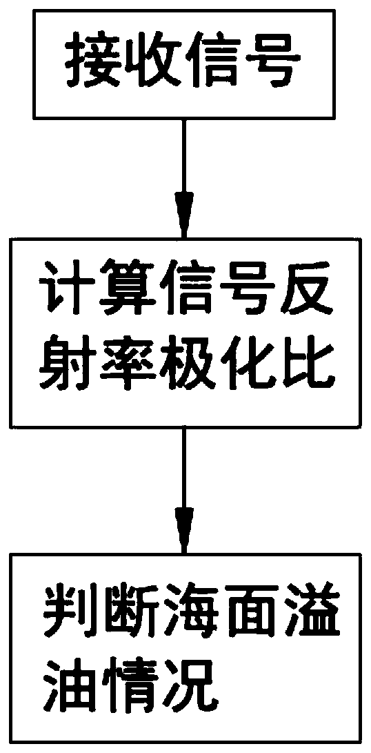
[0024] like Figure 1 to Figure 3 As shown, a GNSS-R shore-based sea oil spill remote sensing detection method includes the following steps:
[0025] (1) Receiving signals: Receive the direct and reflected signals in the detection equipment through GNSS-R technology;
[0026] (2) Calculation of signal reflectivity polarization ratio: for received direct and reflected signals, the calculation method of signal power value and reflectivity is used. The relationship between reflectivity and power value is as follows, where Γ represents reflectivity, Indicates the power value:
[0027]
[0028] According to the above formula, the left-handed reflectivity Γ is obtained by comparing the power with the direct signal rl and dextrorotatory reflectance Γ rr The ratio, put into the above formula, we get:
[0029]
[0030] Among them, θ refers to the satellite elevation angle; χ(v z ) represents the characteristic function of the scattering coefficient and the rough surface hei...
Embodiment 2
[0036] A GNSS-R shore-based sea oil spill remote sensing detection method, comprising the steps of:
[0037] (1) Receiving signals: Receive the direct and reflected signals in the detection equipment through GNSS-R technology;
[0038] (2) Calculation of signal reflectivity polarization ratio: for received direct and reflected signals, the calculation method of signal power value and reflectivity is used. The relationship between reflectivity and power value is as follows, where Γ represents reflectivity, Indicates the power value:
[0039]
[0040] According to the above formula, the left-handed reflectivity Γ is obtained by comparing the power with the direct signal rl and dextrorotatory reflectance Γ rr The ratio, put into the above formula, we get:
[0041]
[0042] Among them, θ is the satellite elevation angle; χ(v z ) represents the characteristic function of the scattering coefficient and the height Z of the rough surface after the electromagnetic wave is sc...
Embodiment 3
[0049] A GNSS-R shore-based sea oil spill remote sensing detection method, comprising the steps of:
[0050] (1) Receiving signals: Receive the direct and reflected signals in the detection equipment through GNSS-R technology;
[0051] (2) Calculation of signal reflectivity polarization ratio: for received direct and reflected signals, the calculation method of signal power value and reflectivity is used. The relationship between reflectivity and power value is as follows, where Γ represents reflectivity, Indicates the power value:
[0052]
[0053] According to the above formula, the left-handed reflectivity Γ is obtained by comparing the power with the direct signal rl and dextrorotatory reflectance Γ rr The ratio, put into the above formula, we get:
[0054]
[0055] Among them, θ is the satellite elevation angle; χ(v z ) represents the characteristic function of the scattering coefficient and the height Z of the rough surface after the electromagnetic wave is sc...
PUM
 Abstract
Description
Claims
Application Information
 - R&D
- Intellectual Property
- Life Sciences
- Materials
- Tech Scout
- Unparalleled Data Quality
- Higher Quality Content
- 60% Fewer Hallucinations
Browse by: Latest US Patents, China's latest patents, Technical Efficacy Thesaurus, Application Domain, Technology Topic, Popular Technical Reports.
© 2025 PatSnap. All rights reserved.Legal|Privacy policy|Modern Slavery Act Transparency Statement|Sitemap|About US| Contact US: help@patsnap.com