
Method of measuring sand wave shape parameters of dry river bed based on aerial survey topographic data of unmanned aerial vehicle (UAV)

A technology of morphological parameters and topographical data, which is applied in the directions of surveying devices, photogrammetry/video metrology, surveying and navigation, etc., can solve the problems of small measurement area, a large amount of labor, cumbersome operation, etc., and achieve scientific and reasonable methods and work The effect of small amount and easy on-site operation

Pending Publication Date: 2019-11-19
CHANGSHA UNIVERSITY OF SCIENCE AND TECHNOLOGY
View PDF0 Cites 2 Cited by
  • Summary
  • Abstract
  • Description
  • Claims
  • Application Information

AI Technical Summary

Problems solved by technology

[0003] At present, the commonly used technical means and measurement methods are manual measurement or the use of side-scan sonar to intervene in the measurement of sand wave shape parameters. These traditional methods require carrying a large number of heavy tools, walking to the river bank or renting a boat, and it takes a certain amount of time to perform the measurement. The measurement area is small, the operation is cumbersome, requires a lot of labor and financial resources, and the accuracy is low, and the error caused by manual operation is large and unavoidable

Method used


Image

  • Method of measuring sand wave shape parameters of dry river bed based on aerial survey topographic data of unmanned aerial vehicle (UAV)
  • Method of measuring sand wave shape parameters of dry river bed based on aerial survey topographic data of unmanned aerial vehicle (UAV)

Examples


Embodiment Construction

[0020] The present invention will be described in further detail below in conjunction with accompanying drawing and example.

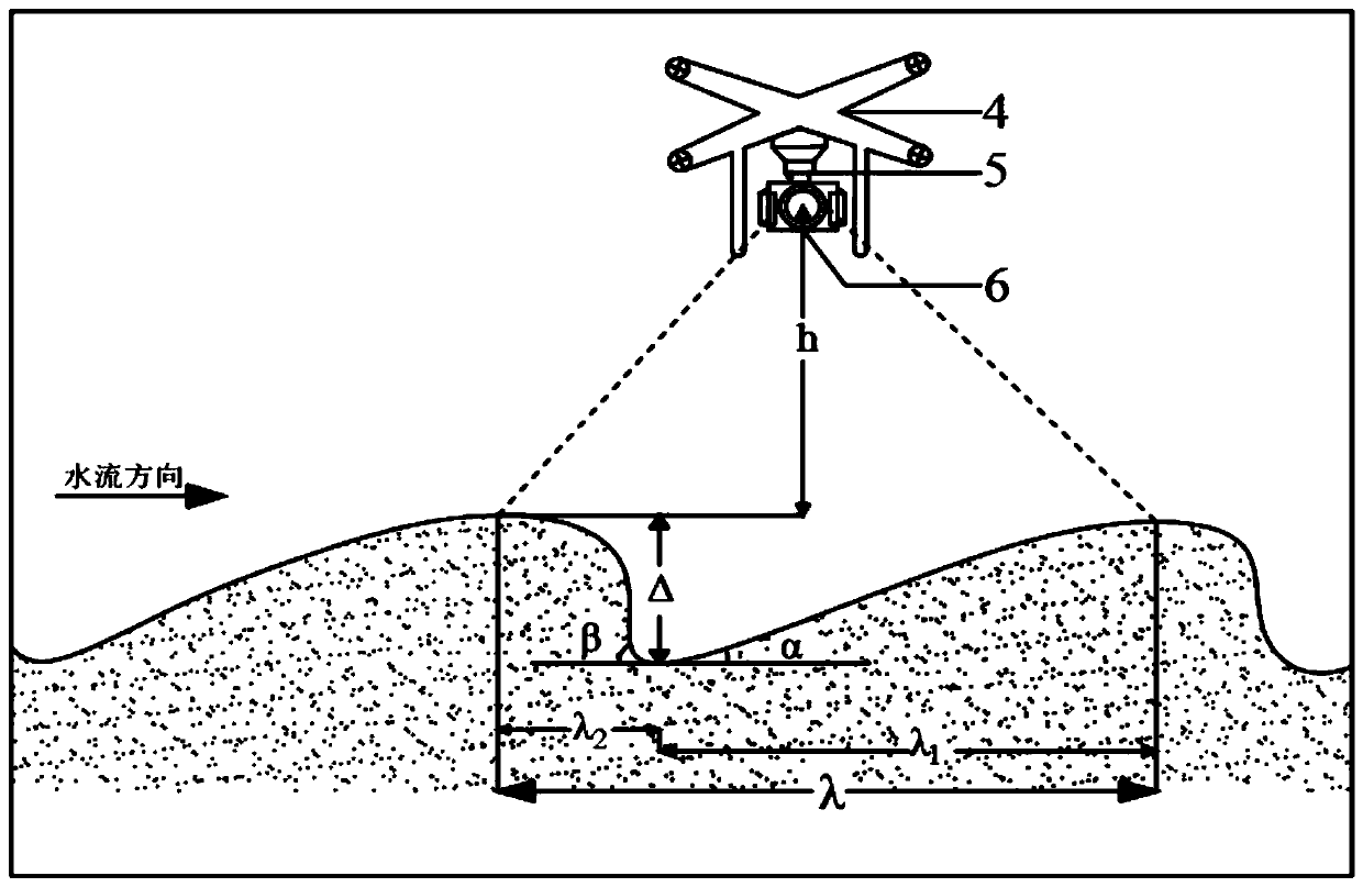
[0021] The present invention is mainly aimed at the measurement of the sand wave form parameters of dry riverbeds, and the tools used include straightedge, lime powder, unmanned aerial vehicle and RTK. The operation steps are as follows:

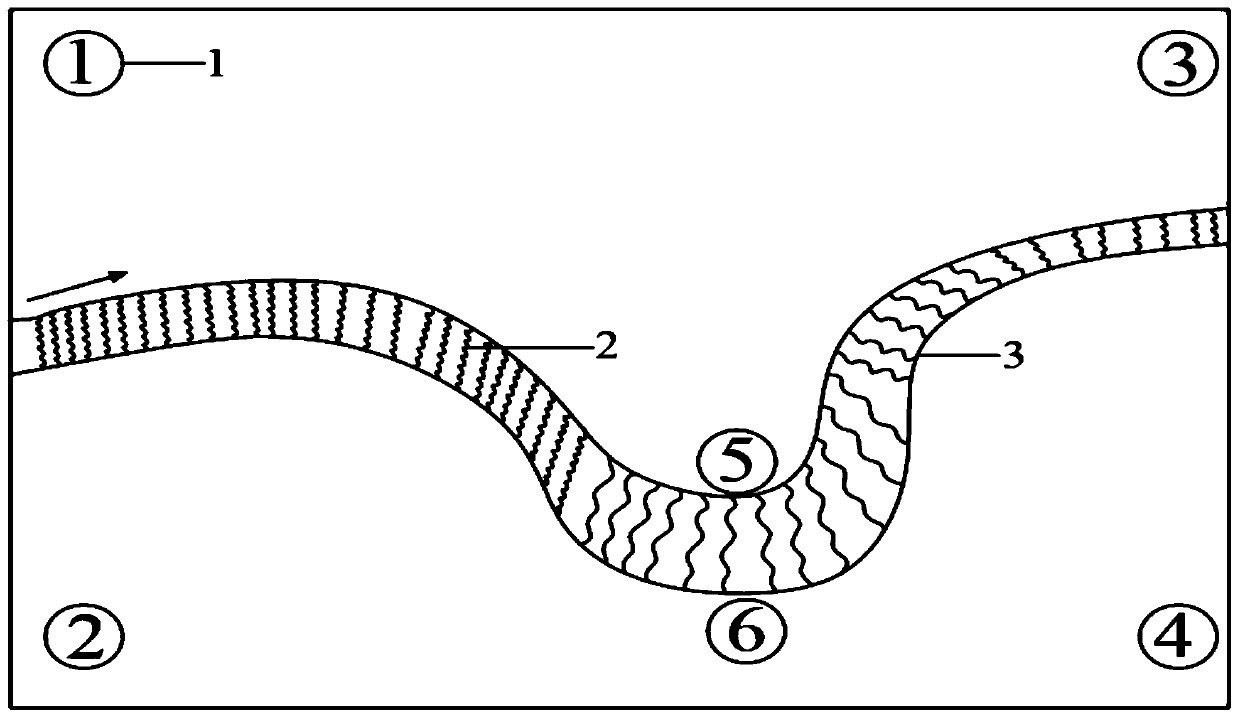
[0022] 1. Determine the dry river bed that needs to be studied and measured (hereinafter referred to as the A river bed), confirm the boundary of the A river bed, and sprinkle lime powder on the boundary to fix the points. When the 4 points of the boundary are determined, look for the highest point in turn in the direction of the river flow , the lowest point, complex terrain points and inflection points, continue to sprinkle lime powder on these points, and number them sequentially.

[0023] 2. Arrange RTK points for the points that have been numbered with lime. Lime powder numbers are used because lime powder fix...


PUM


Abstract

The invention discloses a method of measuring sand wave shape parameters of a dry river bed based on aerial survey topographic data of an unmanned aerial vehicle (UAV). The main technical means is toconduct UAV low-altitude aerial survey on a selected dry river bed to measure the sand wave height delta and the total wavelength lambda, and based on the requirements of sand wave topographic spatialresolutions of different dry river beds, the flight height and the overlap of the UAV are determined, and aerial survey image data are obtained. By adopting a RTK (Real-time kinematics) carrier phasedifference technology, certain characteristic elevation points are obtained for topographic data correction. The image processing tools of ArcMap, Cloud Compare, and Pix4D are used to perform depth processing of DEM data noise to obtain reliable, high-precision and high-resolution topographic data. Through final measurement and calculation, the sand wave shape parameters such as the total wavelength lambda, an upstream wavelength lambda1, a downstream wavelength lambda2, the sand wave height delta, an upstream wave angle alpha and a downstream wave angle beta of the dry river bed are obtained.

Description

technical field [0001] The invention relates to the fields of riverbed evolution, sediment movement mechanics, application of unmanned aerial vehicle aerial survey technology, terrain data processing and the like. Background technique [0002] Sand wave is a specific form formed by the collective movement of sediment particles on the river bed. It generally develops and exists in natural rivers, and is the result of the interaction between water flow, sediment and the river bed. Sand wave is an important form of moving sediment movement, and its development is closely related to riverbed resistance, near-bottom water flow and sediment movement. Natural rivers have various forms and different flow conditions. As the flow conditions increase, the sand wave form will go through several different stages of development. Waves, rapids and deep pools. The whole process is divided into two distinct stages: in the first stage, sand ripples and ridges appear; in the second stage, sa...

Claims


Application Information

Patent Timeline
Patent Type & Authority Applications(China)
IPC IPC(8): G01C7/02G01C11/00
CPCG01C7/02G01C11/00Y02A90/30
Inventor 李志威徐艺菲游宇驰鲁瀚友汤韬谭岚王赞成姚佳姜英豪
Owner CHANGSHA UNIVERSITY OF SCIENCE AND TECHNOLOGY
Learn More