Track center line automatic detection method based on vehicle-mounted mobile laser point cloud

A laser point cloud and orbit centerline technology, applied in image data processing, instrument, character and pattern recognition, etc., can solve the problem of orbit misclassification, waste computer computing time, etc., and achieve the effect of improving computing efficiency

Active Publication Date: 2020-01-03
CHINA RAILWAY DESIGN GRP CO LTD
View PDF7 Cites 38 Cited by
  • Summary
  • Abstract
  • Description
  • Claims
  • Application Information

AI Technical Summary

Problems solved by technology

The author uses the prior knowledge of the catenary above the track when performing a rough classification of the point cloud, but some non-electrified railway lines do not have a catenary structure, and the catenary will also have a branch structure. In these cases, the above method is Unable to perform rough classification of orbital point cloud correctly
[0007] Although the above methods can realize the automatic extraction of orbit point cloud and the calculation of orbit centerline, they all need to process all point cloud data, which consumes more computer computing time, and may also cause orbit misclassification

Method used


Image

  • Track center line automatic detection method based on vehicle-mounted mobile laser point cloud
  • Track center line automatic detection method based on vehicle-mounted mobile laser point cloud
  • Track center line automatic detection method based on vehicle-mounted mobile laser point cloud

Examples


Embodiment 1

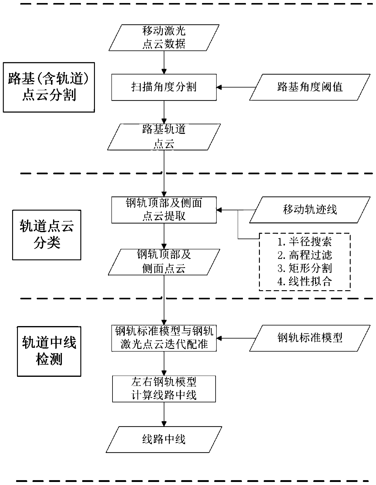
[0138] Step 1: Subgrade (including track) point cloud segmentation

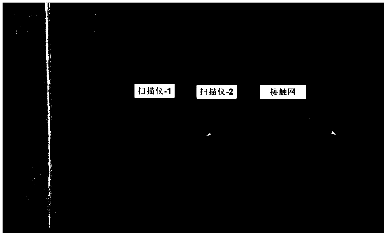
[0139] In order to verify the correctness of the method of the present invention, the RIEGL VMX-450Rail system is used for data acquisition. The system mainly consists of the following parts: 1) Two full-band VQ-450 laser scanning heads; 2) 4 high-resolution industrial cameras; 3) POSPAC LV510GNSS / IMU positioning and attitude determination system.

[0140] The system is mounted on top of a car, which is then secured to the rear of the train's flatbed, allowing laser scanners to acquire data on the lower track. The scanning accuracy is about 8mm, the maximum effective measurement rate is about 1.1 million points per second, and the point density on the rail transit subgrade at the bottom of the scanner is about 1200 points / square meter. The original scanning point cloud is as follows: Figure 7 shown.

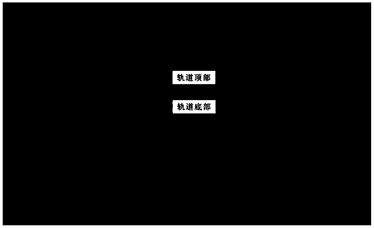
[0141] In order to evaluate the reliability and precision of the method, the scanning experiment was carri...


PUM


Abstract

The invention discloses a track center line automatic detection method based on vehicle-mounted mobile laser point cloud. The method comprises the following steps: S1, point cloud segmentation of a roadbed and a track; s2, track point cloud classification; s3, automatic track center line detection: according to a cross section design drawing of a standard steel rail, automatically reconstructing astandard three-dimensional geometric model of the steel rail in a segmented manner, carrying out iterative registration on the standard steel rail model and the segmented steel rail point cloud in the S2, and carrying out automatic reconstruction on a segmented three-dimensional model of the steel rail; calculating track geometric parameters by utilizing the reconstructed track three-dimensionalgeometric model, calculating track center line point locations in a segmented manner on the basis of the reference track, and sequentially connecting the track center line point locations extracted inthe segmented manner to form a line center line. According to the method, roadbed and rail point clouds can be rapidly segmented, the area of rail point cloud classification search is reduced, automatic classification of laser point clouds on the surfaces of left and right steel rails is realized, and the precision requirement of existing rail transit midline detection can be met.

Description

technical field [0001] The invention relates to the field of rapid comprehensive detection of rail traffic, in particular to an automatic detection method of a track centerline based on a vehicle-mounted mobile laser point cloud. Background technique [0002] The track of rail transit is the most important part of the entire rail transit project, and the geometric state of the track directly affects the safe and stable operation of the train. After long-term operation and maintenance of rail transit lines, the geospatial position of the line will move, and the geometric shape of the track will change. The detection of the center line of the rail transit becomes an important task during the operation and maintenance of rail transit and before the line transformation. The traditional way to measure the center line of the line mainly uses total stations, global satellite positioning systems, geometric levels, track inspection trolleys and other equipment to carry out contact po...

Claims


Application Information

Patent Timeline
Patent Type & Authority Applications(China)
IPC IPC(8): G06K9/00G06K9/62G06T7/136G06T7/66G06T5/00
CPCG06T7/136G06T7/66G06T5/002G06T2207/10028G06T2207/30252G06V20/588G06F18/24
Inventor 许磊刘成王长进李亚辉张冠军梁永王宏涛谭兆秦守鹏牟春霖康占龙洪江华谢春喜张天航张志刚赵宗泽
Owner CHINA RAILWAY DESIGN GRP CO LTD
Why Eureka
Try Eureka