On-orbit high-precision light-weight global image control point database construction method and system

A construction method and technology of control points, which can be used in still image data retrieval, still image data indexing, special data processing applications, etc. The effect of improving the rate and ensuring the accuracy

Active Publication Date: 2020-01-07
XIDIAN UNIV
View PDF4 Cites 4 Cited by
  • Summary
  • Abstract
  • Description
  • Claims
  • Application Information

AI Technical Summary

Problems solved by technology

The lack of on-orbit image control point data in the on-orbit surveying and mapping process will limit the development of on-orbit surveying and mapping processing technology
[0017] (2) In the existing technology, there is no requirement for on-orbit surveying and mapping processing, and under the condition of small database storage volume, higher-precision control point information is not provided for the surveying and mapping process, resulting in the inability to guarantee the quality of on-orbit surveying and mapping processing products precision
[0018] (3) In the existing technology, the design idea of ​​the satellite image control point database is quite different, and a relatively unified system standard has not been formed. It is difficult for developers to improve and supplement the database functions according to the existing conditions, resulting in poor universality of the database. Poor scalability and low data utilization
[0019] (4) In the existing technology, the satellite remote sensing images are not classified and stored according to the remote sensing image processing flow, so that the remote sensing technology developers cannot obtain enough information to carry out relevant research work
Therefore, one of the difficulties of the above-mentioned technical problems is that the construction of the satellite image control point database needs to meet the functional requirements and data accuracy requirements of on-orbit surveying and mapping processing
[0022] (2) Technicians need the control point data information provided by the satellite image control point database to be complete, the data quality is reliable, and the information of the control point image film needs to cover the whole world as much as possible. This requirement results in a large unit volume of the control point data block
Therefore, one of the difficulties of the above-mentioned technical problems is to carry out lightweight processing on the control point database, so that the overall volume of the satellite image control point data will not be too large
[0023] (3) During the use of the satellite image control point database, technicians often affect their work efficiency because the database design does not meet the requirements for use, and the existing database usually only provides limited functions
[0024] (4) When remote sensing technicians study the remote sensing image processing process, it is difficult to accurately obtain the image data corresponding to the process

Method used


Image

  • On-orbit high-precision light-weight global image control point database construction method and system
  • On-orbit high-precision light-weight global image control point database construction method and system
  • On-orbit high-precision light-weight global image control point database construction method and system

Examples


Embodiment

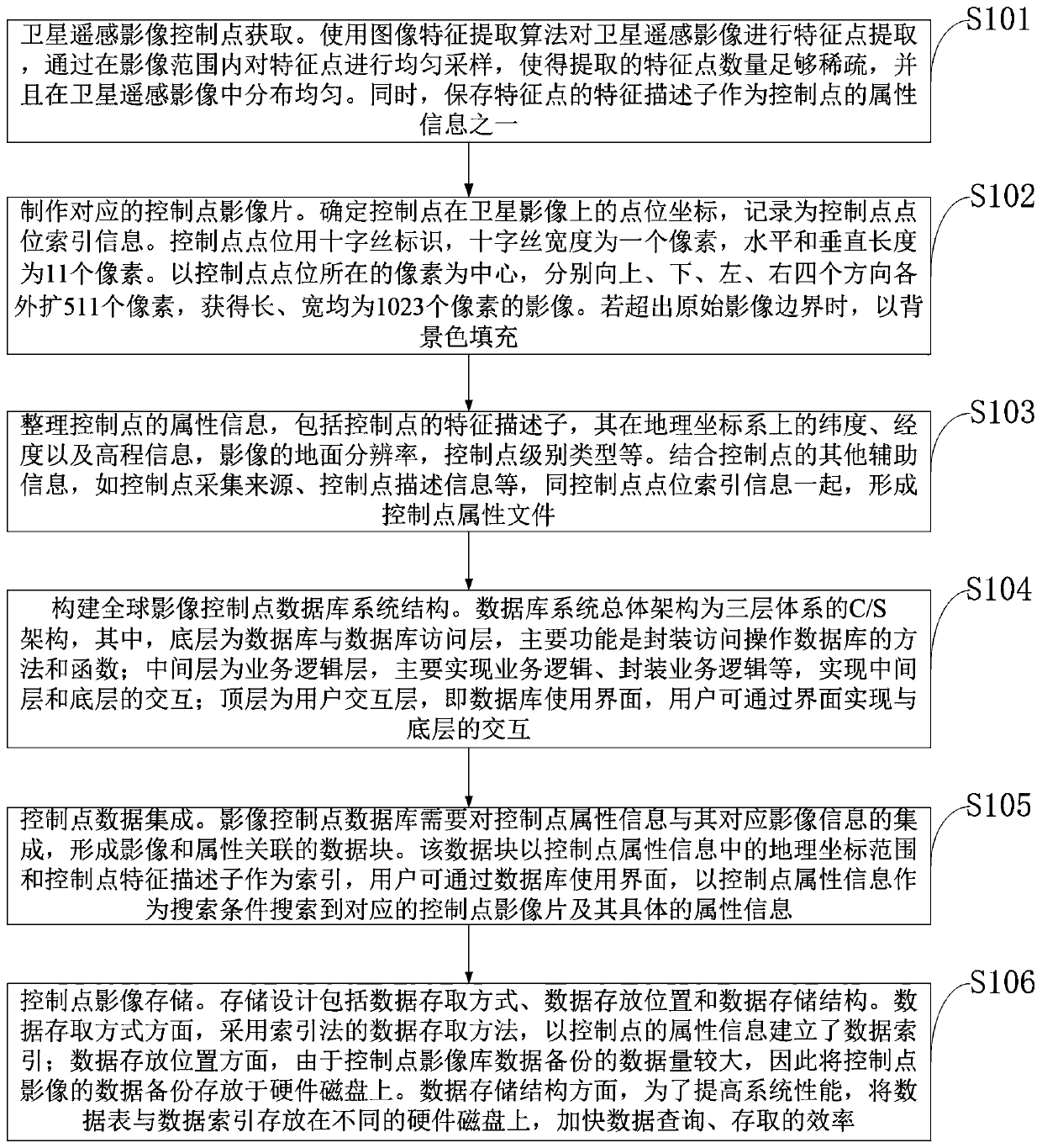
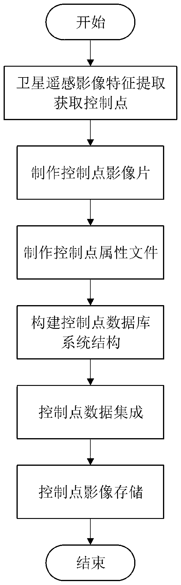
[0087] Such as figure 2 As shown, the on-orbit high-precision lightweight global image control point database construction method provided by the embodiment of the present invention first obtains the satellite remote sensing image to be processed and its corresponding control point attribute information for processing. The specific steps are as follows:

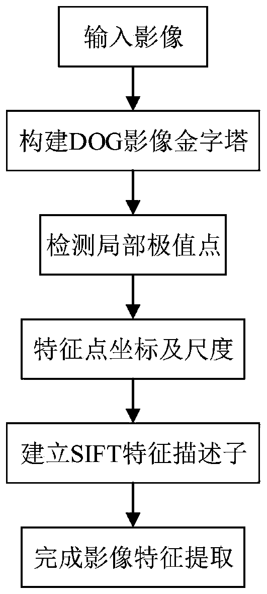
[0088] Step 1, use the SIFT image feature extraction algorithm to perform preliminary extraction of feature points on satellite remote sensing images, the process is as follows image 3 As shown, and then use the uniform sampling algorithm to make the number of feature points in the image range sparse and evenly distributed. Image feature descriptors calculated using the SIFT algorithm such as Figure 4 As shown, each feature point is represented by an 8-dimensional direction vector in a total of 16 seed blocks of 4×4. Therefore, each feature descriptor is a 128-dimensional feature vector.

[0089] Step 2. Determine the po...


PUM


Abstract

The invention belongs to the technical field of remote sensing image processing, and discloses an on-orbit high-precision light-weight global image control point database construction method and system, and the method comprises the steps: obtaining a control point of a satellite remote sensing image through employing an image feature extraction algorithm and a uniform sampling algorithm; making acorresponding control point image film, and determining point location index information of a control point; sorting the attribute information of the control point to form a control point attribute file; constructing a global image control point database system structure; associating the control point image film with the control point attribute file by using a data integration technology to form acontrol point data block; and formulating a database storage strategy, and storing the control point images into a database. The method is suitable for remote sensing images provided by different global satellites, is refined in structure, simple to implement, small in database volume, high in data precision, high in expandability, and meets the requirements of on-orbit surveying and mapping processing.

Description

technical field [0001] The invention belongs to the technical field of remote sensing image processing, and in particular relates to a method and system for constructing an on-orbit high-precision and lightweight global image control point database. Background technique [0002] Currently, the closest prior art: [0003] Satellite remote sensing image data has become an indispensable and important data source for the survey and research of islands and coastal zones in my country. Coastline survey, sea area use, ecological survey and evaluation, oil spill and red tide monitoring all require data support from satellite images. However, for a long time, remote sensing image data are stored in the form of files in the computer, and are managed extensively by the operating system. As the amount of data continues to grow, the disadvantages of this management method become more and more obvious, and the need to establish a remote sensing image database arises as the times require....

Claims


Application Information

Patent Timeline
Patent Type & Authority Applications(China)
IPC IPC(8): G06F16/51
CPCG06F16/51
Inventor 宋锐曹锴郎蒋唯娇李娇娇李云松张古月夏亚奇
Owner XIDIAN UNIV
Why Eureka
Try Eureka