Method for increasing number of sea surface reflection signals received by GNSS-R height measurement satellites

A technology of sea surface reflection and satellite reception, which is applied in the field of satellite altimetry, can solve the problems affecting the coverage area of ​​the antenna, and achieve the effect of improving work efficiency and reliability

Active Publication Date: 2020-02-21
CHINA ACADEMY OF SPACE TECHNOLOGY
View PDF5 Cites 15 Cited by
  • Summary
  • Abstract
  • Description
  • Claims
  • Application Information

AI Technical Summary

Problems solved by technology

In addition, the antenna pointing will also affect the coverage area of ​​the antenna

Method used


Image

  • Method for increasing number of sea surface reflection signals received by GNSS-R height measurement satellites
  • Method for increasing number of sea surface reflection signals received by GNSS-R height measurement satellites
  • Method for increasing number of sea surface reflection signals received by GNSS-R height measurement satellites

Examples


Embodiment 1

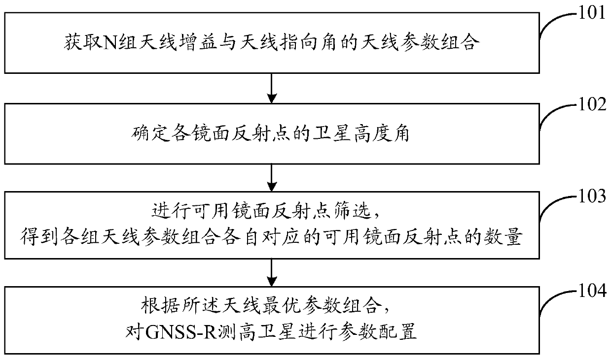
[0028] Such as figure 1 , in this embodiment, the method for increasing the number of sea surface reflection signals received by GNSS-R altimetry satellites includes:

[0029] Step 101, acquiring N sets of antenna parameter combinations of antenna gain and antenna directivity angle.

[0030] In this embodiment, the combination of antenna parameters refers to any combination of multiple antenna gains and multiple antenna directivity angles. Wherein, N>250000.

[0031] Step 102, obtaining the position information of all specular reflection points calculated and output by GPS satellite ephemeris and TDS-1 satellite ephemeris within 24 hours, and determining the satellite elevation angle of each specular reflection point.

[0032] In this embodiment, the data sources used are mainly as follows:

[0033] TDS-1 satellite data

[0034] Launched on July 8, 2014, the TDS-1 satellite is a technology verification satellite designed by the United Kingdom. The satellite carried eight ...

Embodiment 2

[0075] In this embodiment, the establishment process of the GNSS-R satellite-borne down-look antenna SNR model GSNASNRM can be as follows:

[0076] Such as Image 6 , according to the relative position of the GNSS-R altimetry satellite and the GNSS satellite, combined with the geometric theorem ( Figure 4 Point P is the mirror reflection point, and point O is the center of the earth), the following formula (3) can be obtained:

[0077]

[0078] Among them, R TP Indicates the distance from the GNSS satellite to the specular reflection point, R PR Indicates the distance from the GNSS-R altimetry satellite to the specular reflection point, R E is the radius of the earth, H T Indicates the height of the GNSS satellite, H R Indicates the altitude of the GNSS-R altimetry satellite.

[0079] Solving equation (3), we get:

[0080]

[0081] In order to more accurately evaluate the performance of the antenna's ability to receive signals, it is necessary to calculate the si...

Embodiment 3

[0097] On the basis of the above embodiments, the present invention also provides verification and simulation results of the method for increasing the number of sea surface reflection signals received by GNSS-R altimetry satellites.

[0098] Signal-to-noise ratio of received GNSS reflected signal

[0099] In this embodiment, TDS-1 satellite observation data is used to verify the reliability of GSNASNRM, so when calculating SNR, the parameter setting should be as consistent as possible with TDS-1. Among them, the orbit height of the GNSS-R altimetry satellite is set to 635km, the downward-looking antenna is set to point to the nadir with a gain of 13.3dBi, the frequency of the received signal is set to 1575.42MHz in the L1 band, the wavelength is 0.19m, and the antenna temperature is set to 300K , since the TDS-1 observation data has been despread by pseudo code, therefore, the noise bandwidth is set to 1000Hz. Such as Figure 7 , gives the relationship between the signal-to-...


PUM


Abstract

The invention discloses a method for increasing the number of sea surface reflection signals received by GNSS-R height measurement satellites. The method comprises the following steps: obtaining antenna parameter combinations of N groups of antenna gains and antenna pointing angles; acquiring position information of all mirror reflection points, and determining a satellite altitude angle of each mirror reflection point; under the condition of each group of antenna parameter combinations, screening available mirror reflection points according to the mirror reflection points, and obtaining the number of available mirror reflection points corresponding to each group of antenna parameter combinations; determining a group of antenna parameter combinations with the largest number of available mirror reflection points as an optimal antenna parameter combination; and according to the optimal antenna parameter combination, configuring parameters of the GNSS-R height measurement satellite to increase the number of sea surface reflection signals received by the GNSS-R height measurement satellite. According to the invention, the number of sea surface reflection signals received by GNSS-R height measurement satellites is increased.

Description

technical field [0001] The invention belongs to the technical field of satellite altimetry, and in particular relates to a method for increasing the number of sea surface reflection signals received by GNSS-R altimetry satellites. Background technique [0002] Global sea surface height data can be used to invert the ocean gravity field, obtain seabed topography, and establish ocean tide models, playing an important role in the research of geodesy, geophysics, ocean dynamics and other fields. At present, sea surface altimetry data can be obtained through ship surveys, tide gauge stations and satellite altimeters. However, the sampling efficiency of ship surveying and tide gauge stations is low and cannot cover the global ocean; although satellite altimeters can obtain high-precision sea surface height data on a global scale, their spatial resolution cannot meet the needs of mesoscale observations. [0003] As a new bistatic microwave remote sensing technology, GNSS-R altimet...

Claims


Application Information

Patent Timeline
Patent Type & Authority Applications(China)
IPC IPC(8): G01S19/24G01S19/30G01S19/37
CPCG01S19/24G01S19/30G01S19/37
Inventor 郑伟刘宗强吴凡李钊伟
Owner CHINA ACADEMY OF SPACE TECHNOLOGY
Why Eureka
Try Eureka