Outdoor unmanned aerial vehicle positioning method and system based on LoRa

A positioning method and unmanned aerial vehicle technology, applied in radio wave measurement system, service based on location information, service based on specific environment, etc., can solve the problem that signal attenuation is greatly affected by environmental factors, distance error, and affect the accuracy of positioning results and other issues to achieve the effect of weakening the change of RSSI and position relationship, improving accuracy, and avoiding being easily affected by the environment

Active Publication Date: 2020-04-24
SOUTHEAST UNIV
View PDF8 Cites 9 Cited by
  • Summary
  • Abstract
  • Description
  • Claims
  • Application Information

AI Technical Summary

Problems solved by technology

Since the value of c is very large, if T is inaccurate, the distance error will be large
The principle of positioning by RSSI is that the distance is estimated by signal strength, and the attenuation of the signal is greatly affected by environmental factors, and the signal may enter the terminal after reflection from buildings, etc., affecting the accuracy of positioning results

Method used


Image

  • Outdoor unmanned aerial vehicle positioning method and system based on LoRa
  • Outdoor unmanned aerial vehicle positioning method and system based on LoRa
  • Outdoor unmanned aerial vehicle positioning method and system based on LoRa

Examples


Embodiment Construction

[0025] The present invention will be further described in detail below in conjunction with the accompanying drawings and specific embodiments.

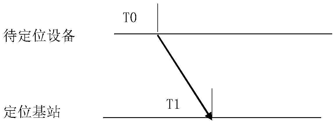
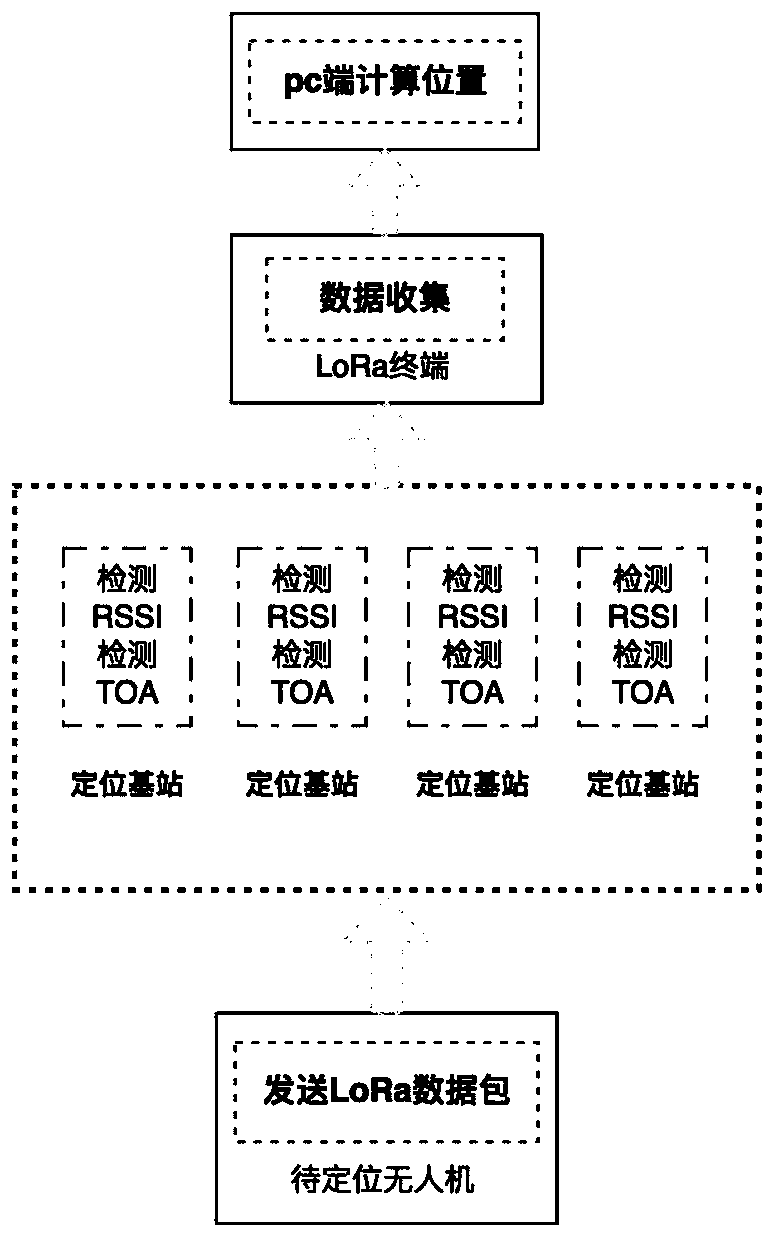
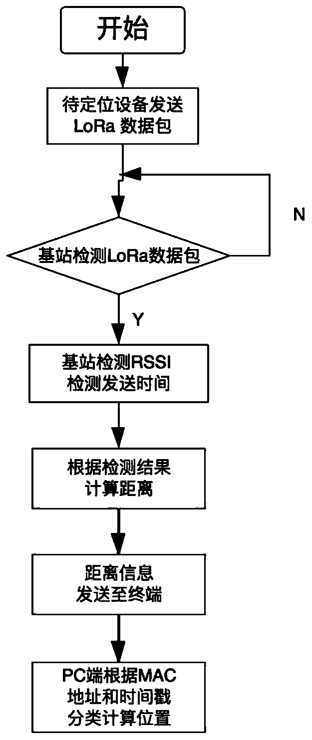
[0026] Since there are buildings, ground, etc. in the environment, the signal of the UAV will be reflected. Therefore, the signal received by the positioning base station in the non-line-of-sight transmission environment (nlos) may be the signal obtained without reflection, or it may be the signal after reflection. Signal. In order to effectively screen the signal, we take the reference value RSSI of the signal strength and the signal time-of-flight TOA as the input reference data at the same time. A LoRa-based outdoor UAV positioning method disclosed in the embodiment of the present invention is mainly divided into two steps: pre-establishing a fingerprint library and positioning.

[0027] Firstly, a fingerprint database is established, and the signal strength is measured within the range covered by the positioning base station. Th...


PUM


Abstract

The invention discloses an outdoor unmanned aerial vehicle positioning method and system based on LoRa. The method comprises the following steps: discretizing a signal coverage range of each positioning base station to construct a fingerprint library of a signal RSSI and distance mapping relation, and fitting each positioning base station to obtain corresponding parameters in an RSSI and distancefitting formula; enabling a to-be-positioned unmanned aerial vehicle to send a LoRa data packet with a signal sending timestamp, and after the positioning base station receives the data packet, performing screening according to the arrival time TOA to calculate the average value of RSSI of the qualified data packet; and calculating the distance between the to-be-positioned unmanned aerial vehicleand the positioning base stations according to a fitting formula, and determining the unmanned position by combining the distances between the plurality of positioning base stations and the to-be-positioned unmanned aerial vehicle. According to the invention, TOA and RSSI are comprehensively utilized for positioning, the defects that the error is too large when TOA is utilized for calculating thedistance, and RSSI distance measurement accuracy is easily affected by the environment are overcome, and the positioning precision of the outdoor unmanned aerial vehicle is effectively improved.

Description

technical field [0001] The invention relates to a LoRa (Long Range Radio)-based outdoor UAV positioning method and system, belonging to the technical field of Internet of Things wireless communication. Background technique [0002] Today, outdoor positioning is primarily done using Global Navigation Satellite System (GNSS) receivers. At present, there are many kinds of GPS receivers on the market, but they have a fatal shortcoming, the problem of battery life, which needs to be recharged every few days. The current consumption of the GPS receiver is about 30-50mA, which is quite a lot of energy consumption for most low power IoT devices. For example, in the "on" state, the LoRa module operating in the 868MHz frequency band consumes 2.8mA for data transmission and 14.2mA for receiving data. Therefore, GPS positioning has its limitations. Any terminal equipped with LoRa can support the positioning function, its power consumption is lower than that of GPS sensors, and its ba...

Claims


Application Information

Patent Timeline
Patent Type & Authority Applications(China)
IPC IPC(8): H04W4/02H04W4/06H04W4/40H04W64/00G01S11/06
CPCG01S11/06H04W4/023H04W4/06H04W64/006H04W4/40
Inventor 胡静宋铁成许璐夏玮玮燕锋沈连丰
Owner SOUTHEAST UNIV
Why Eureka
Try Eureka