Photovoltaic power station unmanned aerial vehicle inspection method and system based on machine learning
A machine learning and unmanned aerial vehicle technology, applied in the field of unmanned aerial vehicles, can solve the problems of low efficiency and huge manpower investment, and achieve the effect of fast moving speed, reduced overall noise and fast speed
- Summary
- Abstract
- Description
- Claims
- Application Information
AI Technical Summary
Problems solved by technology
Method used
Image
Examples
Embodiment 1
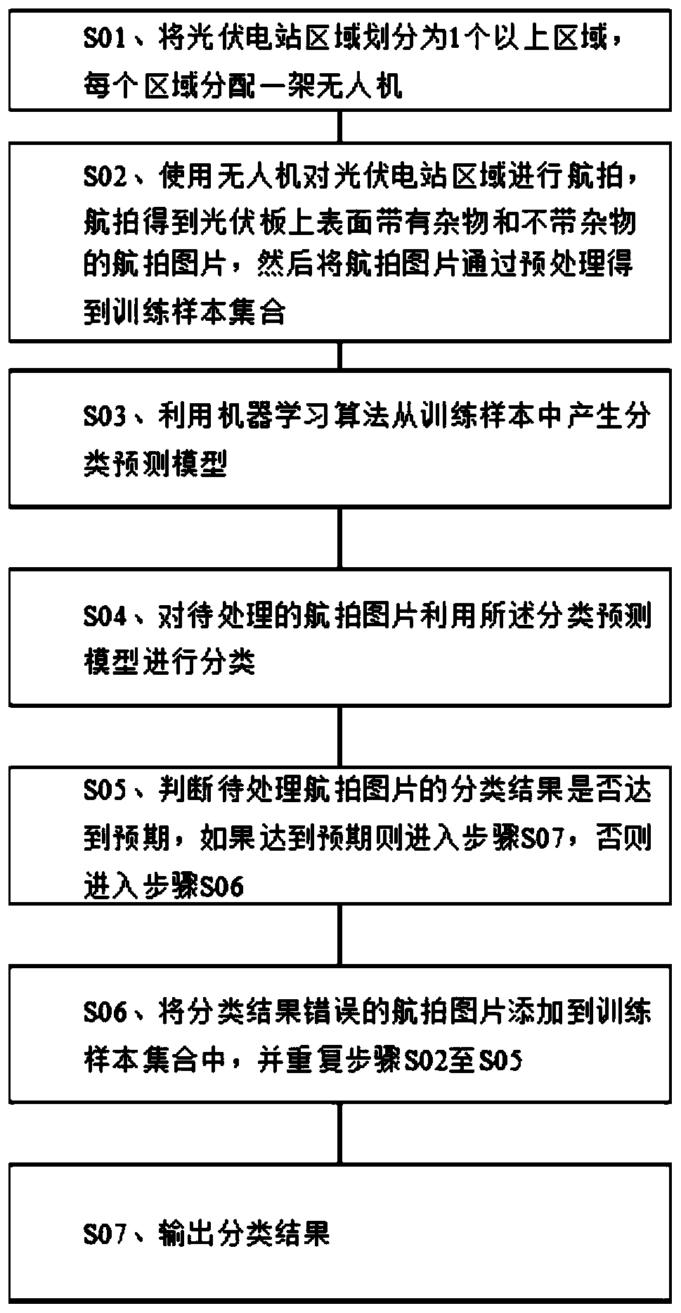
[0049] Example 1: Reference figure 1 , a machine learning-based drone inspection method for photovoltaic power plants, including the following steps:
[0050] S02. Use a drone to take aerial photos of the photovoltaic power station area, and obtain aerial photos with and without debris on the surface of the photovoltaic panel, and then preprocess the aerial photos to obtain a training sample set;
[0051] S03, using a machine learning algorithm to generate a classification prediction model from the training samples;
[0052] S04. Classify the aerial pictures to be processed by using the classification prediction model;
[0053] S05. Judging whether the classification result of the aerial image to be processed meets the expectation, if it meets the expectation, enter step S07, otherwise enter step S06;
[0054] S06. Add the aerial pictures with incorrect classification results to the training sample set, and repeat steps S02 to S05;
[0055] S07. Outputting classification re...
Embodiment 2
[0083] Implementation Example 2: Reference figure 2 , a photovoltaic power plant UAV inspection system based on machine learning, including: an area division module, the area division module is used to divide the photovoltaic power plant area map into more than one area, each area is assigned a UAV , the area division module is a piece of computer code, which can divide the map into areas; the unmanned aerial vehicle is used to take aerial photos of the areas allocated by the area division module, and send the aerial pictures to the image preprocessing module, without The man-machine is connected with the data of the area division module, and the drone can sample the aerial photography drone produced by DJI and other companies; the picture preprocessing module, the picture preprocessing module receives the aerial pictures taken by the drone, and then converts the aerial pictures in the aerial pictures The photovoltaic panels are individually cut out to form a training sample ...
PUM
 Abstract
Description
Claims
Application Information
 - R&D
- Intellectual Property
- Life Sciences
- Materials
- Tech Scout
- Unparalleled Data Quality
- Higher Quality Content
- 60% Fewer Hallucinations
Browse by: Latest US Patents, China's latest patents, Technical Efficacy Thesaurus, Application Domain, Technology Topic, Popular Technical Reports.
© 2025 PatSnap. All rights reserved.Legal|Privacy policy|Modern Slavery Act Transparency Statement|Sitemap|About US| Contact US: help@patsnap.com


