Vehicle real-time positioning method and system and vehicle

A real-time positioning and vehicle technology, used in satellite radio beacon positioning systems, radio wave measurement systems, and re-radiation, etc., can solve problems such as poor satellite positioning accuracy and accumulated errors, and achieve the effect of improving positioning accuracy.

Pending Publication Date: 2020-08-18
福瑞泰克智能系统有限公司
View PDF0 Cites 8 Cited by
  • Summary
  • Abstract
  • Description
  • Claims
  • Application Information

AI Technical Summary

Problems solved by technology

However, the inventive scheme uses satellite positioning as the global data. When the accuracy of satellite positioning is poor, it only relies on local information for positioning, and the local information positioning technology uses inter-frame matching to find the pose. This positioning method has cumulative errors and is not suitable for long-term wireless positioning. In the case of satellite positioning, otherwise it will lead to large deviations

Method used


Image

  • Vehicle real-time positioning method and system and vehicle
  • Vehicle real-time positioning method and system and vehicle
  • Vehicle real-time positioning method and system and vehicle

Examples


Embodiment 1

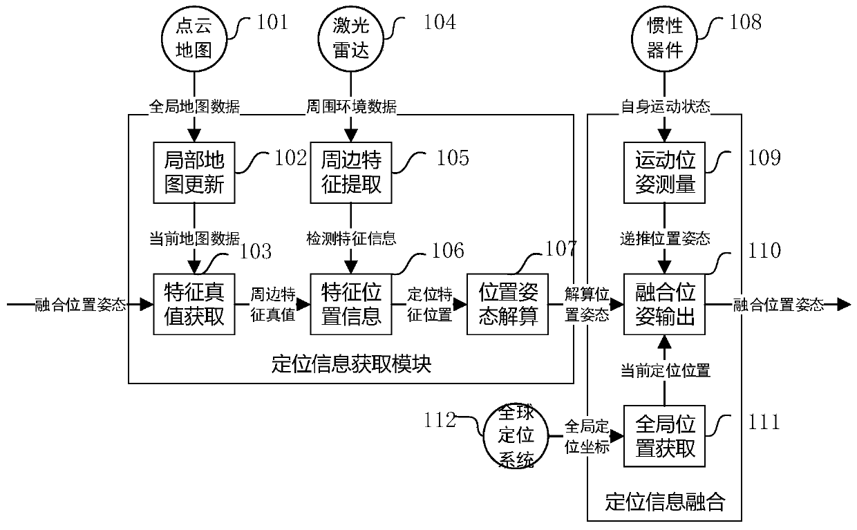
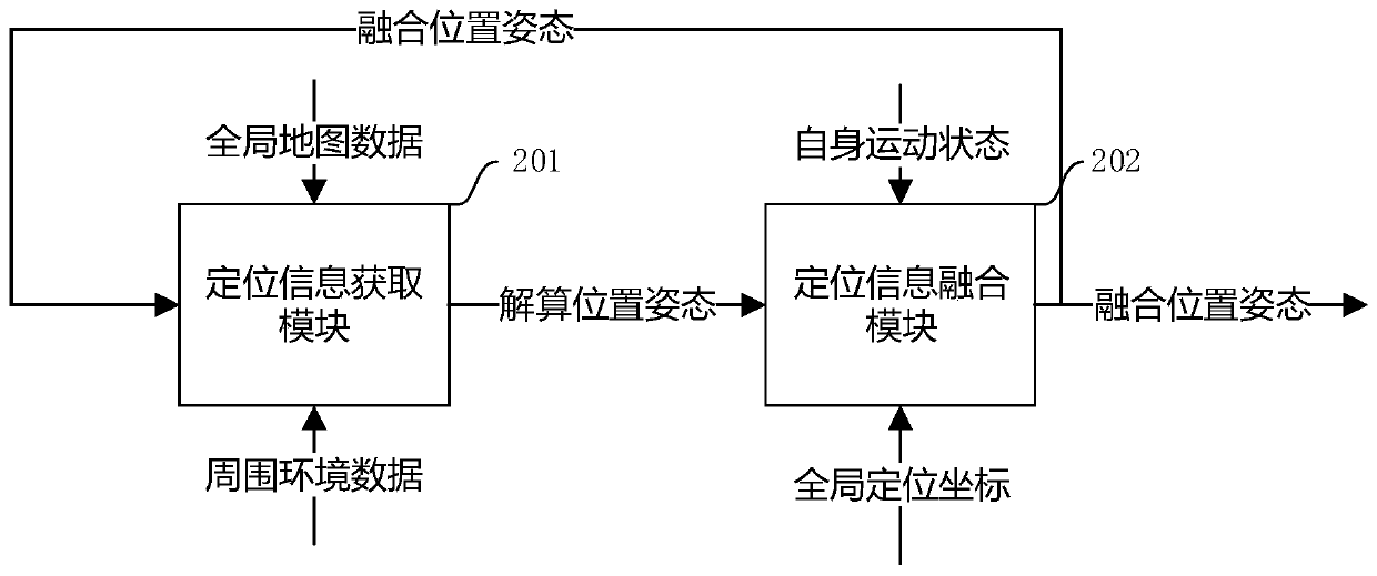
[0043] Such as figure 1 As shown, point cloud map 101, global map data, local map update, current map data, feature true value acquisition 103,

[0044] Lidar 104, surrounding feature extraction 105, feature position information 106, position and attitude calculation 107, inertial device 108, motion pose measurement 109, fusion pose output 110, GPS receiver 112, global position acquisition 111.

[0045] A point cloud map 101 is set in the ADAS system, global map data is obtained in advance from the point cloud map 101 , and a local map update 102 can be obtained from the point cloud map 101 . Convert the latitude and longitude of the global map data into position information, thereby obtain the local map update 102, and intercept a sufficiently large range as the current map data. From the global map data, the surrounding feature true 103 is obtained. Construct the surrounding feature truth-value dictionary, in which the feature attribute is used as the key and the feature p...

Embodiment 2

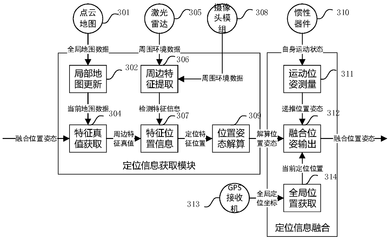
[0059] Such as Figure three as shown in figure 1 As shown, point cloud map 301, global map data, local map update, current map data, feature true value acquisition 304,

[0060] Lidar 305, surrounding environment data, surrounding feature extraction 306, detection feature information, feature position information 307, positioning feature position, position and attitude calculation 309, position and attitude calculation, inertial device 310, motion pose measurement 311, fusion pose Output 312, GPS receiver 313, global position acquisition 314, fusion position and attitude.

[0061] A point cloud map 301 is set in the ADAS system, global map data is obtained in advance from the point cloud map 301 , and a local map update 302 can be obtained from the point cloud map 301 . The latitude and longitude of the global map data is converted into position information, so as to obtain the local map update 302, and a sufficiently large range is intercepted as the current map data. Obt...

Embodiment 3

[0077] Such as Figure 4 Shown is point cloud map 401 , global map data, local map update, current map data, feature truth value acquisition 103 .

[0078] Lidar 403, surrounding environment data, surrounding feature extraction 404, detection feature information, feature position information 405, positioning feature position, position and attitude calculation 406, position and attitude calculation, inertial device 407, motion pose measurement 408, fusion pose Output 409.

[0079] A point cloud map 401 is set in the ADAS system, which is obtained in advance from the point cloud map 401 , and a local map update 102 can be obtained from the point cloud map 401 . Convert the latitude and longitude of the global map data into position information, thereby obtain the local map update 102, and intercept a sufficiently large range as the current map data. From the global map data, the surrounding feature ground truth 103 is obtained. Construct the surrounding feature truth-value di...


PUM


Abstract

The invention mainly provides a vehicle real-time positioning method. The vehicle real-time positioning method mainly comprises the steps: acquiring a feature true value database according to map information, wherein the map is global map data; acquiring surrounding information for the point cloud map to obtain feature position information; searching in a feature truth value database according tothe attribute of the feature position information to obtain a positioning feature position; performing position and posture calculation on the positioning feature position to obtain a calculated posture, performing data fusion on the GPS information, the vehicle motion posture and the calculated posture, and outputting a fused posture. According to the method, the used global information is known,and the searching speed is high; after the static global position is obtained, the global position information of the vehicle is deduced according to the geometrical relationship between the vehicleand the static global position; the number of the used static information is small, and accumulated errors do not exist.

Description

Technical field: [0001] The invention relates to the field of automatic driving, in particular to a real-time positioning method for automatic driving. Background technique: [0002] The invention relates to the field of positioning technology, and is mainly used for real-time positioning of unmanned vehicles, and is applicable to various situations including but not limited to satellite positioning that is good or bad. [0003] As an emerging intelligent tool, unmanned vehicle is an application case of system engineering integrating multiple technologies. It needs to realize the planning of driving path and the control of vehicle motion on the basis of its own positioning and environmental perception. Therefore, Being able to position in a variety of road conditions is very important. Usually, positioning technology uses a combination of satellites and IMUs to achieve positioning, because its position is mainly determined by satellites. In some scenarios where satellite po...

Claims


Application Information

Patent Timeline
IPC IPC(8): G01C21/34G01S17/931G01S17/86G01C21/16G01S19/53G01C22/00
CPCG01C21/3415G01S17/931G01S17/86G01C21/165G01S19/53G01C22/00
Inventor 康宁张川峰蒋成
Owner 福瑞泰克智能系统有限公司
Why Eureka
Try Eureka