Smart city CIM imaging method based on pedestrian activity and density perception

A pedestrian and urban technology, applied in image analysis, geometric CAD, image data processing, etc., can solve the problems of scattered information, no global perspective, and less effective data in smart cities, reducing system transmission burden, reducing storage burden, and improving The effect of accuracy

Inactive Publication Date: 2020-09-04
张仲靖
View PDF0 Cites 4 Cited by
  • Summary
  • Abstract
  • Description
  • Claims
  • Application Information

AI Technical Summary

Problems solved by technology

[0005] On the one hand, urban road cameras are generally used to monitor pedestrians and vehicles, and often do not automatically adjust the camera refresh rate according to the activity and density of pedestrians, resulting in less effective data and higher power consumption
On the other hand, existing smart city imaging often does not have a global perspective, and various information about smart cities is relatively scattered.

Method used


Image

  • Smart city CIM imaging method based on pedestrian activity and density perception
  • Smart city CIM imaging method based on pedestrian activity and density perception
  • Smart city CIM imaging method based on pedestrian activity and density perception

Examples


Embodiment 1

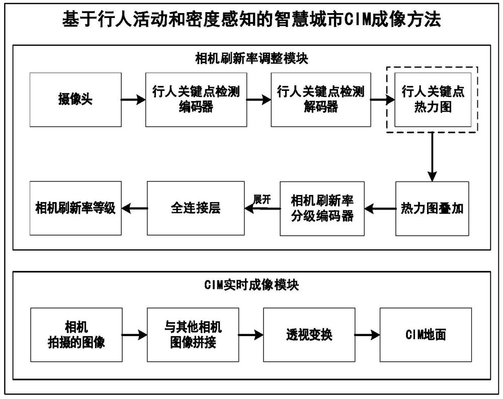
[0038] In order to realize the method of the present invention, it is necessary to construct the city information model CIM and the internal relationship of the information exchange module.

[0039] CIM refers to the organic synthesis of three-dimensional urban space model and building information based on urban information data, mainly composed of urban GIS data and BIM data.

[0040] The information exchange module mainly includes the three-dimensional urban space model and urban information, and will update its model and information content in real time as the construction progress of the smart city continues.

[0041] This solution uses CIM technology, which can better realize real-time imaging of urban road scenes.

[0042] Based on three-dimensional urban spatial geographic information, CIM superimposes the BIM information of urban buildings, above-ground and underground facilities, and urban Internet of Things information to construct a three-dimensional digital space u...


PUM


Abstract

The invention discloses a smart city CIM imaging method based on pedestrian activity and density perception. The method comprises the following steps: constructing a city information model of a three-dimensional digital space; performing pedestrian labeling; training a pedestrian key point extraction network; superposing the pedestrian key point thermodynamic diagrams of the continuous frames, training a camera refresh rate grading network by using an added thermodynamic diagram result, performing pedestrian key point detection network processing, superposing and camera refresh rate grading network processing on the continuous image frames acquired by the camera in real time, and outputting a camera real-time refresh rate grade; adjusting the refresh rate of the camera in real time according to the real-time refresh rate grade of the camera, collecting images, splicing the images, and visually displaying the city information model on a Web page. According to the invention, intelligentsmart city image acquisition is realized, pedestrian detection and analysis precision is improved, camera power consumption is reduced, and model visualization results are richer.

Description

technical field [0001] The invention relates to the technical fields of artificial intelligence, smart city, and CIM, in particular to a CIM imaging method for a smart city based on pedestrian activity and density perception. Background technique [0002] With the acceleration of urbanization and global economic integration, while cities are developing rapidly, they are also facing many problems in sustainable development. The existing urban management model has been limited, and new technologies and measures must be sought. Optimize resource allocation, improve management level, and improve the ability to serve the people. [0003] The emergence of smart cities stems from the new generation of information technology represented by the Internet of Things, cloud computing, mobile Internet, and artificial intelligence and the open urban innovation ecology that is gradually bred under the environment of a knowledge society. Smart city emphasizes the use of a new generation of ...

Claims


Application Information

Patent Timeline
Patent Type & Authority Applications(China)
IPC IPC(8): G06T17/00G06T17/05G06T7/30G06F30/13G06F16/29G06K9/00G06K9/62G06K9/46G09B29/00
CPCG06T17/00G06T17/05G06T7/30G06F30/13G06F16/29G09B29/007G06V40/10G06V10/462G06F18/214Y02D10/00
Inventor 张仲靖于志强
Owner 张仲靖
Why Eureka
Try Eureka