Multi-terminal cooperative forest crown geomorphic mapping system and method

A kind of multi-terminal and forest technology, applied in radio wave measurement system, satellite radio beacon positioning system, electromagnetic wave re-radiation and other directions, can solve the problem of low positioning accuracy, reduce accuracy, improve positioning accuracy, and ensure consistency Effect

Pending Publication Date: 2020-10-13
ZHEJIANG XIBEIHU SPECIAL VEHICLE
View PDF6 Cites 1 Cited by
  • Summary
  • Abstract
  • Description
  • Claims
  • Application Information

AI Technical Summary

Problems solved by technology

[0004] The present invention mainly solves the technical problem of low positioning accuracy of the original forest canopy topography mapping system and method; it provides a multi-terminal collaborative forest under canopy topography mapping system and method, which integrates the inertial navigation positioning data of unmanned vehicles with unmanned The vehicle's satellite navigation and positioning data are integrated to improve the positioning accuracy

Method used


Image

  • Multi-terminal cooperative forest crown geomorphic mapping system and method
  • Multi-terminal cooperative forest crown geomorphic mapping system and method
  • Multi-terminal cooperative forest crown geomorphic mapping system and method

Examples


Embodiment

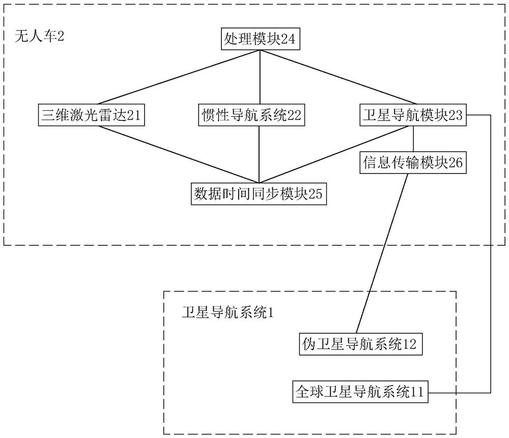
[0044] Embodiment: a kind of multi-terminal cooperative forest topography mapping system under the canopy of this embodiment, such as figure 1 As shown, it includes a satellite navigation system 1 and an unmanned vehicle 2. Wherein the satellite navigation system includes a global satellite navigation system 11 and a pseudolite navigation system 12 .

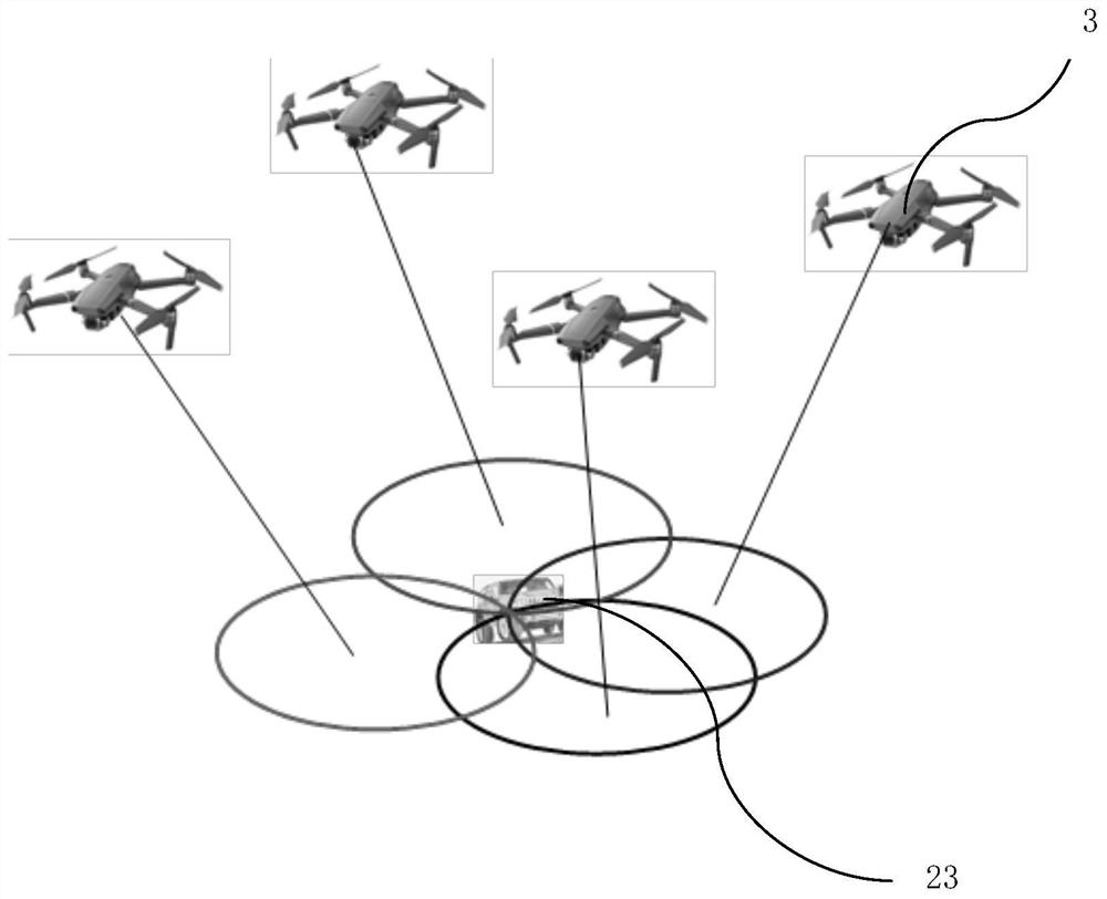
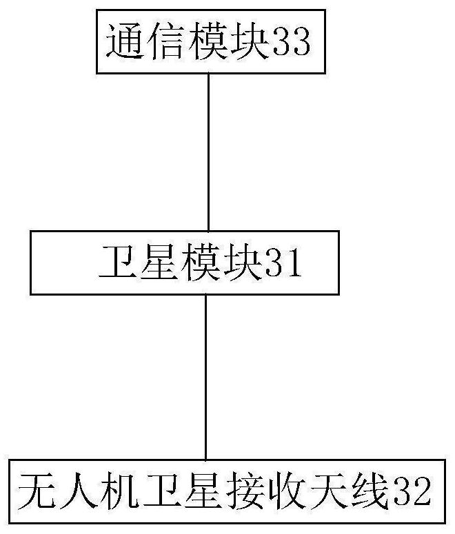
[0045] pseudolite navigation system figure 2 As shown, it consists of a UAV group and an unmanned vehicle, and the UAV group includes four UAVs3. Drones such as image 3 As shown, it includes a satellite module 31, a UAV satellite receiving antenna 32 and a communication module 33, the satellite receiving antenna is connected to the satellite module, and the communication module is connected to the satellite module.

[0046] The unmanned vehicle includes three-dimensional laser radar 21, inertial navigation system 22, satellite navigation module 23, processing module 24, data time synchronization module 25 and information tr...


PUM


Abstract

The invention discloses a multi-terminal cooperative forest crown geomorphic mapping system and method, the system comprises a satellite navigation system and an unmanned vehicle, and the unmanned vehicle is provided with a three-dimensional laser radar, an inertial navigation system, a satellite navigation module and a processing module. The method comprises the following steps: initializing correction time, wherein the three-dimensional laser radar acquires three-dimensional point cloud data of the surrounding space environment of the unmanned vehicle, the inertial navigation system acquiresinertial navigation positioning data of the unmanned vehicle, and the satellite navigation module acquires satellite navigation positioning data of the unmanned vehicle; fusing the inertial navigation positioning data and the satellite navigation positioning data of the unmanned vehicle to obtain real-time positioning information of the unmanned vehicle; and according to the three-dimensional point cloud data and the real-time positioning information, orderly stacking to generate a three-dimensional landform map. According to the method, the inertial navigation positioning data and the satellite navigation positioning data of the unmanned vehicle are fused, so that the positioning precision of the unmanned vehicle is improved, the precision of a three-dimensional landform map is improved,and direct basis and guarantee are provided for an optimal fire extinguishing search and rescue path and scheme when a fire occurs.

Description

technical field [0001] The invention relates to the technical field of map construction, in particular to a system and method for multi-terminal collaborative forest canopy topography construction. Background technique [0002] China's forests are widely distributed and its geographical environment is complex and diverse, so forest fires occur frequently. On average, more than 10,000 forest fires occur in China every year, burning hundreds of thousands to millions of hectares of forests, accounting for about 5-8 ‰ of the country's forest area. In May 1987, a huge forest fire broke out in Daxing'an Mountains, Heilongjiang. The burned area was 1.01 million hectares, of which forested area accounted for 70%. Forest fires burn down trees, burn down forest plant resources, endanger wild animals, cause soil erosion, lower the water quality of downstream rivers, cause air pollution, threaten the safety of people's lives and property, and seriously damage forest structure and fores...

Claims


Application Information

Patent Timeline
Patent Type & Authority Applications(China)
IPC IPC(8): G01C21/16G01S19/47G01S19/48G01S17/86
CPCG01C21/165G01S19/47G01S19/48G01S17/86
Inventor 施东庆贾文良
Owner ZHEJIANG XIBEIHU SPECIAL VEHICLE
Why Eureka
Try Eureka