Road condition preview method suitable for integrated control of vehicle chassis

A chassis integration and vehicle technology, applied in the direction of re-radiation, road network navigator, electromagnetic wave re-radiation, etc., can solve the problems of low precision and poor real-time performance

Pending Publication Date: 2020-10-27
YANSHAN UNIV
View PDF0 Cites 1 Cited by
  • Summary
  • Abstract
  • Description
  • Claims
  • Application Information

AI Technical Summary

Problems solved by technology

[0007] In order to solve the problems of low precision and poor real-time performance in the existing road condition preview method, the present invention proposes a road condition preview method based on multi-sensor

Method used


Image

  • Road condition preview method suitable for integrated control of vehicle chassis
  • Road condition preview method suitable for integrated control of vehicle chassis
  • Road condition preview method suitable for integrated control of vehicle chassis

Examples


Embodiment Construction

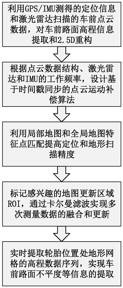
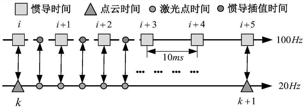
[0066] The online real-time preview of the elevation characteristics of the road surface in front of the vehicle is a key issue in vehicle active / semi-active suspension regulation and vehicle chassis integrated control. For this reason, the present invention first uses multiple sensor data to obtain the point cloud data of the road surface in front of the vehicle, that is, the elevation information of the road surface in front of the vehicle; then in order to further improve the accuracy, the point cloud motion compensation with time stamp synchronization is designed, and the local map and the global map are established. Map feature point matching; then in order to obtain map information in real time, Kalman filter is used to realize the fusion and update of the local map interest area; finally, the elevation data sequence of the terrain grid at the tire is extracted, and the unevenness of the road surface in front of the car is completed. and other information extraction. The...


PUM


Abstract

The invention discloses a road condition preview method suitable for integrated control of a vehicle chassis. The method is used for carrying out online real-time scanning, estimation and measurementon information such as elevation, slope, inclination, unevenness and the like of a road surface, and comprises the following steps: firstly, realizing elevation information extraction and 2.5 D reconstruction of the road surface in front of a vehicle by installing a plurality of sensors; secondly, designing point cloud motion compensation of timestamp synchronization, establishing feature point matching of a local map and a global map, and then, improving terrain scanning precision; next, realizing map fusion and update by utilizing Kalman filtering; and finally, extracting an elevation data sequence of the terrain grid at the tire, and completing extraction of slope, inclination and unevenness by combining the elevation data sequence and elevation information of the road surface in frontof the vehicle. According to the invention, the adaptability and matching performance of vehicle chassis integrated control to road conditions are improved, the problems of failure, instability and slow updating of GPS signals are solved, and the scanning precision and stability of the terrain in front of the vehicle are improved.

Description

technical field [0001] The invention belongs to the field of feature recognition of road surface conditions in front of vehicles, and in particular relates to an online real-time scanning, estimation and measurement method for information such as elevation, slope, and unevenness of the road surface. Background technique [0002] The online real-time preview of the elevation characteristics of the road surface in front of the vehicle is the primary key issue in the integrated control of vehicle active / semi-active suspension regulation and chassis dynamics. When the vehicle is running, since the road conditions in front of the vehicle (including the unevenness, inclination and slope of the road in front of the vehicle, etc.) are random, it is necessary to use sensors for real-time measurement. At present, at home and abroad, the position and attitude of the vehicle body are measured by the combination of differential GPS and IMU (inertial measurement unit), and the point cloud...

Claims


Application Information

Patent Timeline
IPC IPC(8): G01C21/16G01C21/30G01S17/931G01S19/41
CPCG01C21/165G01S19/41G01S17/931G01C21/30Y02T10/40
Inventor 倪涛张泮虹赵丁选孔志飞巩明德刘爽王建涛
Owner YANSHAN UNIV
Why Eureka
Try Eureka