Automatic detection method and system for electric power tower based on 3D laser scanning technology of unmanned aerial vehicle
A laser scanning and automatic detection technology, applied in computer parts, image analysis, image enhancement and other directions, can solve the problems of unstable effect, difficulty in identifying power towers, etc., to improve the scope of application, quickly locate power towers, and realize simple Effect
- Summary
- Abstract
- Description
- Claims
- Application Information
AI Technical Summary
Problems solved by technology
Method used
Image
Examples
Embodiment 1
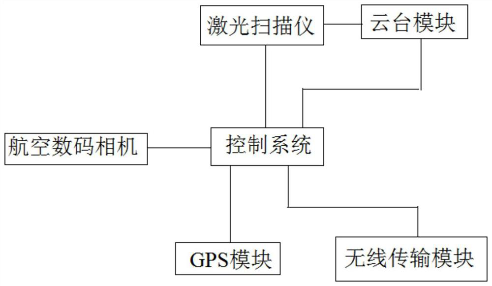
[0033] Embodiment 1: The power tower automatic detection system based on UAV 3D laser scanning, the power tower automatic detection system is loaded on the UAV, including: laser scanner, aerial digital camera and control system, GPS module, wireless transmission module, The pan / tilt module of the laser scanning system. In this embodiment, the aerial digital camera uses binocular cameras to obtain visible light binocular images including power towers. Using laser point cloud and visible light image registration technology to realize power tower detection and power tower extraction and recognition, such as figure 1 shown.
[0034] The laser scanner is used to shoot the laser scanning point cloud data including the power tower; the pan / tilt control module is connected with the laser scanner to control the laser scanner to adjust the angle and direction; the aerial digital camera is used to take pictures including the power tower. The visible light image of the power tower; the ...
Embodiment 2
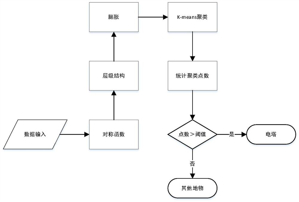
[0036] Embodiment 2: as figure 2 As shown, the power tower automatic detection method based on UAV 3D laser scanning includes the following steps: use the laser scanner to obtain the laser point cloud near the power tower and transmit it to the control system;
[0037] Identify the power tower point cloud data based on the obtained laser scanning point cloud data including the power tower;
[0038] Generate point cloud depth images from power tower point cloud data, and convert 3D data into 2D data;
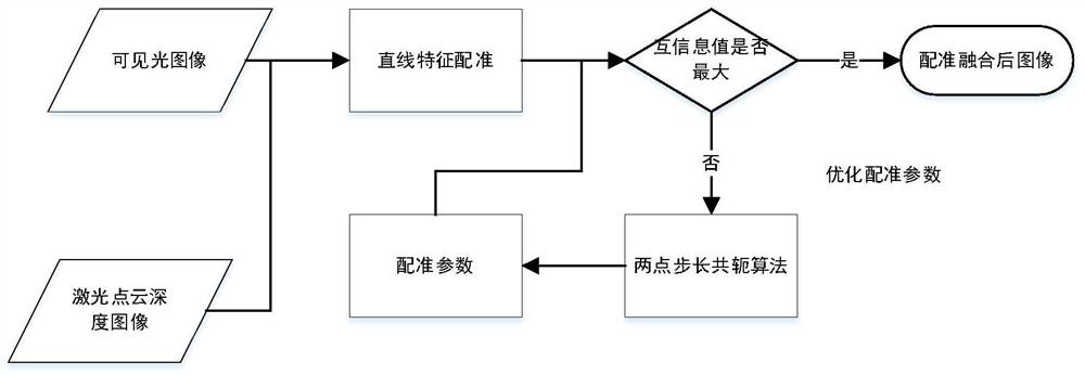
[0039] Coarse registration and fine matching of the two-dimensional data of the power tower and the pre-acquired visible light image including the power tower, including using mutual information as the similarity measure of the registration process, and choosing the two-point step-size conjugate algorithm as the registration strategy, Calculate the mutual information value of the laser point cloud depth image and the visible light image, solve the global optimal registration pa...
Embodiment 3
[0044] Example 3: image 3 It is a flow chart of the image registration algorithm in a specific embodiment of the present invention. This embodiment provides an automatic detection method for power towers based on 3D laser scanning of drones, including:
[0045]First, use the Zhang’s calibration method to calibrate the binocular camera, use the calibrated binocular camera to capture the left and right images of the target to be tested, then eliminate the power lines through the corrosion operation, and then use the expansion operation to obtain the connected area, and then use the K-means mean Clustering to get the point group of each connected area, and then distinguish the tower and other objects by the size of the area;
[0046] After the power tower is identified, the point cloud depth image is generated by laser scanning point cloud data, the three-dimensional data is converted into two-dimensional data, and then the mutual information is used as the similarity measure of...
PUM
 Abstract
Description
Claims
Application Information
 - R&D
- Intellectual Property
- Life Sciences
- Materials
- Tech Scout
- Unparalleled Data Quality
- Higher Quality Content
- 60% Fewer Hallucinations
Browse by: Latest US Patents, China's latest patents, Technical Efficacy Thesaurus, Application Domain, Technology Topic, Popular Technical Reports.
© 2025 PatSnap. All rights reserved.Legal|Privacy policy|Modern Slavery Act Transparency Statement|Sitemap|About US| Contact US: help@patsnap.com


