CAD-GIS system data automatic processing and converting method

A technology of automatic processing and conversion methods, applied in data processing applications, special data processing applications, office automation, etc., can solve the problems of GIS system data lag, low utilization rate of CAD data, etc., to avoid errors, reduce labor maintenance costs, Avoid the effects of the GIS system operation process

Pending Publication Date: 2021-02-09
STATE GRID TIANJIN ELECTRIC POWER +1
View PDF6 Cites 0 Cited by
  • Summary
  • Abstract
  • Description
  • Claims
  • Application Information

AI Technical Summary

Problems solved by technology

So as to solve the problem of low utilization rate of CAD data and lag of GIS system data

Method used


Image

  • CAD-GIS system data automatic processing and converting method
  • CAD-GIS system data automatic processing and converting method
  • CAD-GIS system data automatic processing and converting method

Examples


Embodiment

[0031] A CAD-GIS system data automatic processing and conversion method, comprising the following steps for:

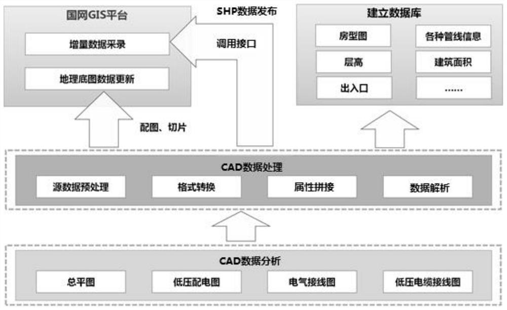
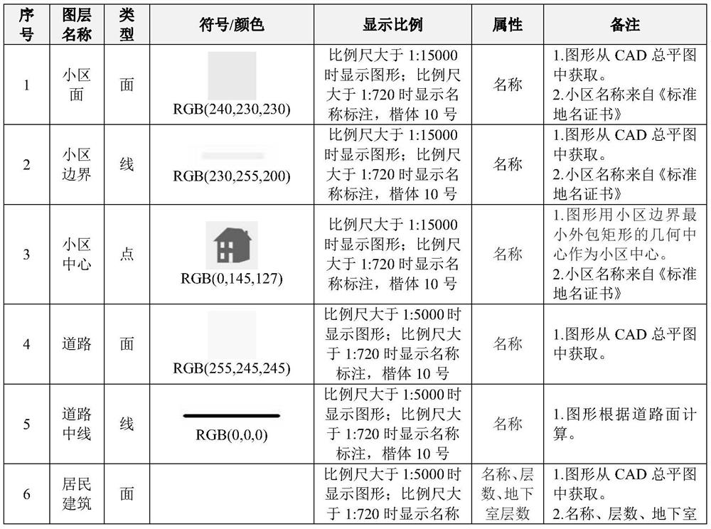
[0032] 1. Analyze CAD data. Graphic processing engineers will analyze CAD data layer by layer according to product design requirements, including roads, buildings, power grid equipment, etc., and generate CAD calculation data, as shown in Table 1 and Table 2 below:

[0033] Table 1 Building Data Schedule

[0034]

[0035]

[0036]

[0037] Table 2 Grid equipment data list

[0038]

[0039]

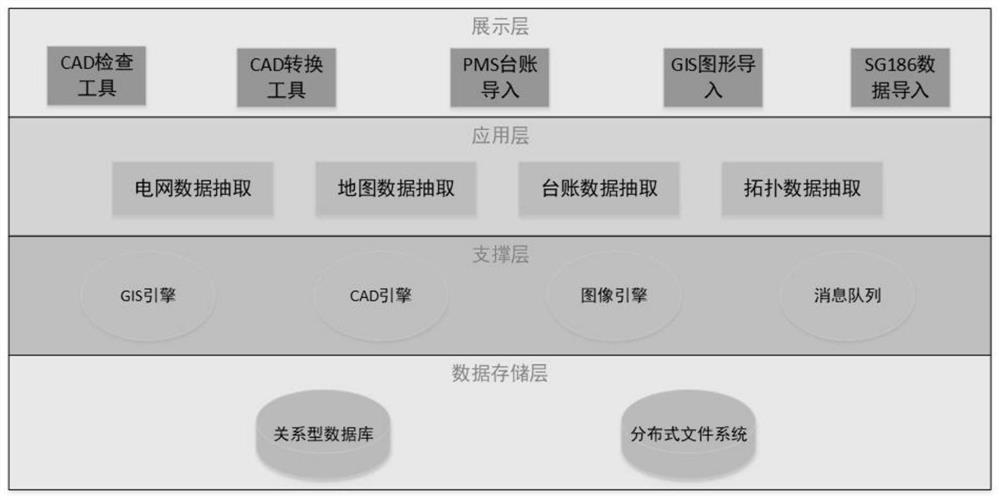
[0040] 2. Automatic processing of CAD data, after data analysis, attribute splicing, and format conversion of product CAD data, CAD data is converted into SHP data. Automatic processing of CAD data is an application of existing technology, and the required power grid data is extracted separately using AUTOCAD software To the corresponding layer, then use the Arcgis service to create the corresponding layer, import the data in the CAD into the layer created by Arcgi...


PUM


Abstract

The invention relates to a CAD-GIS system data automatic processing and converting method. The method at least comprises the following steps: 1) analyzing CAD data, carrying out layer analysis on theCAD data, including roads, buildings, power grid equipment and the like, and generating CAD calculation data; 2) automatically processing the CAD data, performing data analysis, attribute splicing andformat conversion on the product CAD data, and converting the CAD data into SHP data; and 3) SHP data publishing, publishing the converted data to map service through a data publishing module, and completing automatic processing and publishing of CAD to GIS graphic data. According to the method, direct conversion of the result data in the CAD-GIS system can be realized, and a tedious GIS system operation process is avoided, so that the timeliness and the accuracy of the data in the GIS system are improved.

Description

technical field [0001] The invention belongs to the technical field of grid data processing, and in particular relates to a CAD-GIS system data automatic processing and conversion method. Background technique [0002] As a lean management system for equipment in the power industry, the GIS system needs to maintain a large amount of electrical equipment location, ledger, and relationship information into the system. The current method of obtaining the location of buildings and electrical equipment is based on on-site surveying and mapping or vectorization based on images after the construction is completed, and the information is very lagging; while the acquisition method of marketing and allocation data is generally "field collection + internal processing" In the form of combination, field collection takes a long time and the data quality cannot be fully guaranteed. [0003] The computer-aided design software (CAD) is the most widely used in power planning and design. There...

Claims


Application Information

Patent Timeline
Patent Type & Authority Applications(China)
IPC IPC(8): G06F16/25G06F16/29G06Q10/10G06Q50/06
CPCG06F16/258G06F16/29G06Q10/10G06Q50/06
Inventor 冀睿琳冯莹于宏宇赵宏振钱靖张亮李安琪周扬张峥孟繁淞
Owner STATE GRID TIANJIN ELECTRIC POWER
Why Eureka
Try Eureka