Multi-satellite combined inversion method for earth surface soil humidity based on GNSS-IR

A technology for surface soil and soil moisture, which is used in measurement devices, material analysis using microwave means, instruments, etc., can solve difficult soil moisture monitoring and accurate assessment, cannot efficiently screen satellites, and is difficult to accurately grasp the surrounding of the station. Soil moisture information and other issues, to achieve high-precision inversion and improve the effect of abnormal jump problems

Active Publication Date: 2021-03-16
GUILIN UNIVERSITY OF TECHNOLOGY
View PDF20 Cites 6 Cited by
  • Summary
  • Abstract
  • Description
  • Claims
  • Application Information

AI Technical Summary

Problems solved by technology

Regarding the soil moisture inversion model, due to the influence of satellite orbits, different satellites reflect different surface environmental information around the station. It is difficult to accurately grasp the soil moisture information around the station by using a single satellite to invert the soil moisture.
Moreover, for the problem of satellite selection, it is still not possible to efficiently screen qualified satellites
Therefore, existing technologies and methods are still difficult to comprehensively monitor and accurately evaluate soil moisture.

Method used


Image

  • Multi-satellite combined inversion method for earth surface soil humidity based on GNSS-IR
  • Multi-satellite combined inversion method for earth surface soil humidity based on GNSS-IR
  • Multi-satellite combined inversion method for earth surface soil humidity based on GNSS-IR

Examples


Embodiment Construction

[0041] specific implementation plan

[0042] The implementation cases of the present invention will be described in detail below, and the implementation cases are carried out on the premise of the solutions of the present invention. The detailed implementation and specific operation process are given, but the protection scope of the present invention does not include the following implementation cases.

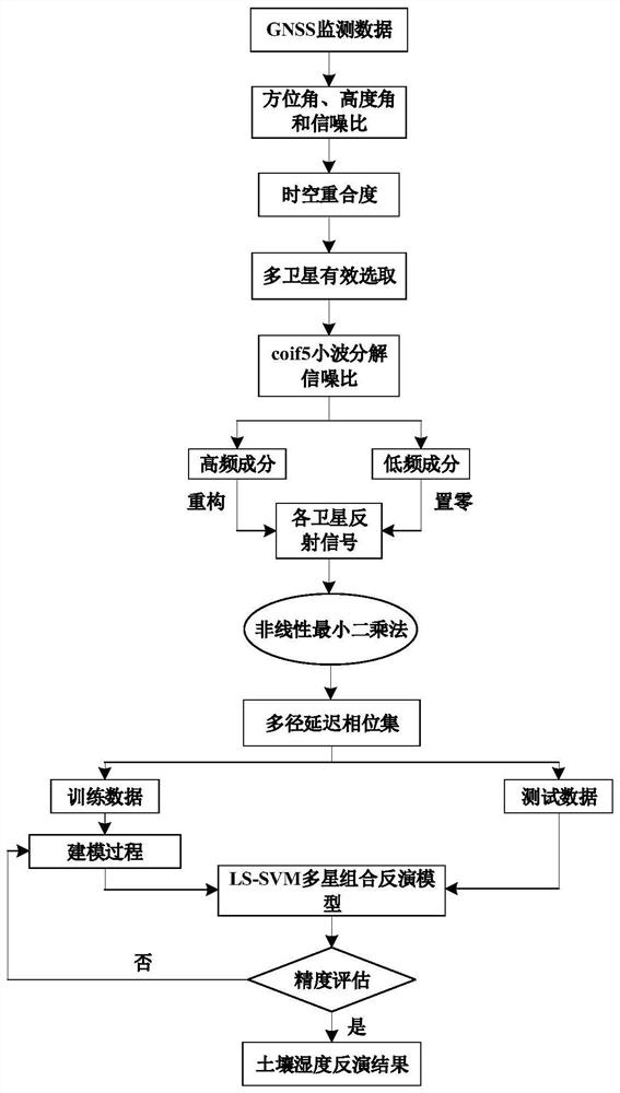
[0043] figure 1 Shown, be the implementation process of the present invention, concrete steps are as follows:

[0044]Step 1: GNSS data collection and preprocessing

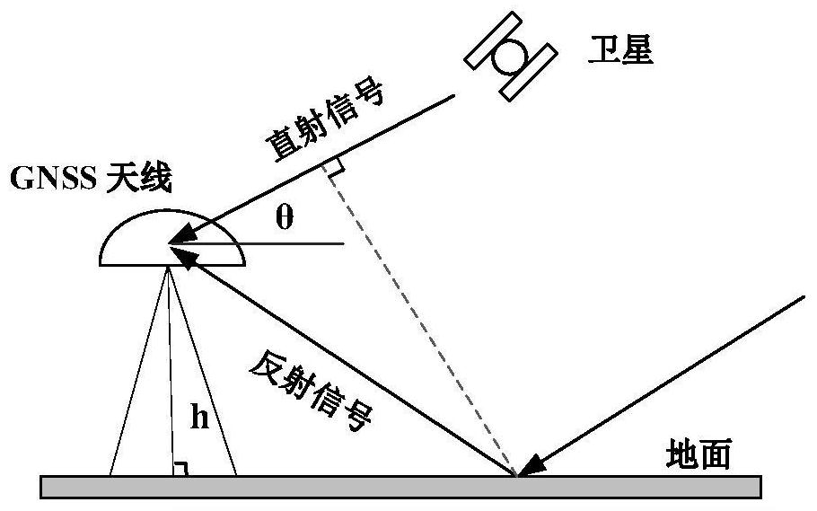
[0045] The observation file: N file and the navigation electronic file: P file obtained by the surveying GNSS receiver are used to extract the azimuth angle, altitude angle and signal-to-noise ratio data of each GNSS satellite through RTKlib software.

[0046] Step 2: Multi-satellite selection based on time-space coincidence.

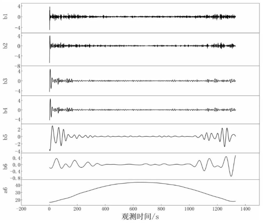
[0047] Based on the data extracted in step 1, reasonably set the satellite cut-off...


PUM


Abstract

The invention discloses a multi-satellite combined inversion method for the earth surface soil humidity based on GNSS-IR, and belongs to the technical field of microwave remote sensing. The method comprises the steps of extracting a satellite altitude angle, an azimuth angle and a signal-to-noise ratio by adopting monitoring data of a measurement type GNSS receiver, and selecting multiple effective satellites through a space-time overlap ratio; separating reflected signals in the signal-to-noise ratios of the satellites by wavelet analysis, resampling the reflected signals with a low elevationangle, and obtaining the multipath delay phase of each satellite through nonlinear least square sine fitting; and finally, establishing a nonlinear relationship between the multipath delay phases ofthe multiple satellites and the soil humidity through a least square support vector machine to realize high-precision inversion of the soil humidity. The method is wide in application range and high in inversion precision, the defects of a traditional satellite reflection signal separation method can be effectively overcome, the problem that soil humidity information around a measurement station is difficult to comprehensively reflect only by adopting a single satellite is solved, and the problems in the prior art are solved.

Description

technical field [0001] The invention belongs to the application field of global satellite navigation system interferometric reflection remote sensing and soil moisture monitoring, and specifically proposes a multi-satellite combination inversion of surface soil moisture based on GNSS-IR (Global Positioning System-Interferometric Reflection, global positioning system interferometric reflection measurement) method. Background technique [0002] Soil moisture is an important parameter in the study of hydrology, meteorology and agricultural environment. Scientific and accurate monitoring of soil moisture is not only of great significance for the study of climate and meteorological forecasts, geological disaster evaluation and water resource cycle issues, but also for agricultural drought monitoring, agricultural The role of rational irrigation and drainage, crop growth evaluation and other aspects is also very important. [0003] So far in practice, there is no technology or me...

Claims


Application Information

Patent Timeline
Patent Type & Authority Applications(China)
IPC IPC(8): G01N22/00G06K9/00G06K9/62
CPCG01N23/00G06F2218/06G06F2218/12G06F18/2411
Inventor 梁月吉任超张志刚
Owner GUILIN UNIVERSITY OF TECHNOLOGY
Why Eureka
Try Eureka