Supercharge Your Innovation With Domain-Expert AI Agents!

Method for unifying elevation and water depth data grid unit numbers

A grid unit and elevation data technology, applied in electrical digital data processing, instruments, design optimization/simulation, etc., can solve the problems that different types of data cannot be used directly, grid numbers and coordinates do not correspond, and calculation results are false. , to achieve the effect of easy to use and copy promotion

Active Publication Date: 2021-05-07
WUHAN UNIV
View PDF7 Cites 3 Cited by
  • Summary
  • Abstract
  • Description
  • Claims
  • Application Information

AI Technical Summary

Problems solved by technology

However, these data are usually calculated by using different software or different modules of the same software. The independence of each software and the difference in the grid numbering rules may cause the problem that the grid numbers and coordinates of different types of data in the same set of grids do not correspond. , which will result in the inability to directly combine different types of data, and the grid data with different numbers should be unified
Existing studies have seldom discussed this, ignoring the difference in grid numbers will not only lead to false calculation results, but may even bring huge economic losses to related engineering research

Method used


Image

  • Method for unifying elevation and water depth data grid unit numbers
  • Method for unifying elevation and water depth data grid unit numbers
  • Method for unifying elevation and water depth data grid unit numbers

Examples


Embodiment Construction

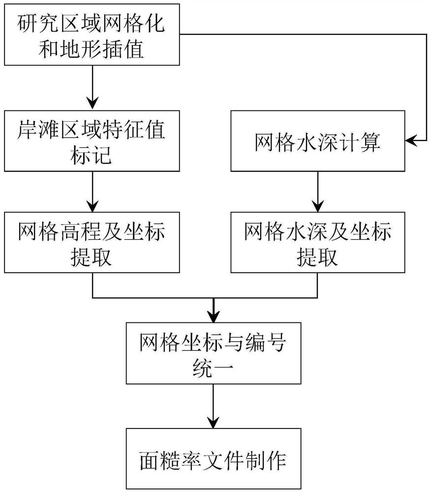
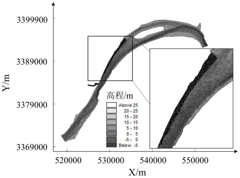
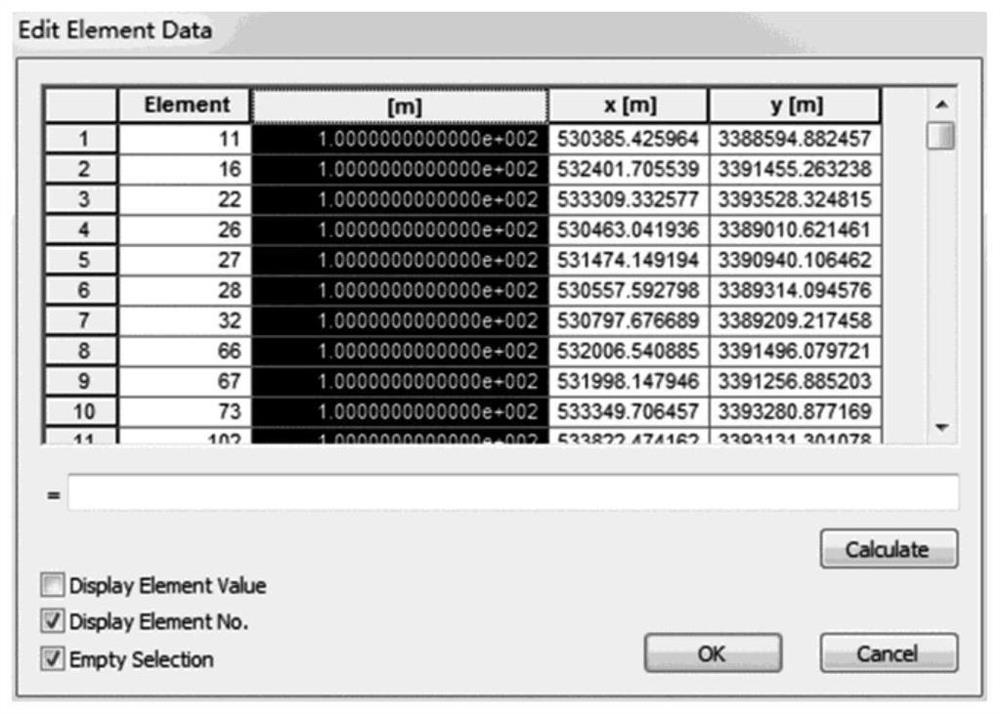
[0048] According to the topographic data and water depth data with different numbers and coordinates under the same set of grids, the present invention converts them into data under the same grid number and coordinates through the principle of the same coordinates. The Mike21 model commonly used in the field of river numerical simulation is used as an example below. The MIKE21 software model was developed by the Danish Hydraulics Institute (DHI), which can be used for simulation studies of currents, waves, sediment and ecological water quality in rivers, lakes, estuaries and sea areas. The model integrates the pre-processing module (PP), hydrodynamic module (HD), convective diffusion module (TR), sediment transport module (ST), mud transport module (MT), oil spill module (OS), particle tracking module (PT) ), etc., as the core module, the hydrodynamic module is the basis for driving the operation of other modules. The pre-processing module has a very powerful automatic mesh ge...


PUM


Abstract

The invention provides a method for unifying elevation and water depth data grid unit numbers. The method comprises the steps of constructing a riverbed original data set; constructing a grid unit and node riverbed elevation data set after terrain interpolation; constructing a grid unit riverbed elevation data set containing vegetation region mark values; constructing a planar two-dimensional water flow model, and calculating to obtain a grid unit water depth data set under each level of flow; carrying out numbering unified calculation processing on the riverbed elevation and water depth data set of the grid units; and in combination with the grid unit riverbed elevation data set and the numbered and unified grid unit water depth data set, calculating through a vegetation equivalent roughness coefficient formula to obtain a riverbed roughness coefficient data set. According to the method, the problem that different grid data numbers are different is solved, the limitation that different data cannot be directly combined for use is overcome, the vegetation equivalent resistance is calculated by jointly using the grid unit elevation and water depth data after the grid numbers are unified, and vegetation resistance changes under different flooding conditions can be accurately reflected.

Description

technical field [0001] The invention relates to the technical field of river numerical simulation, in particular to a method for unifying the grid unit numbers of elevation and water depth data. Background technique [0002] It is a hot issue in the field of numerical simulation of hydraulics and river engineering to study the effect of the increase of riverbed resistance caused by the growth of vegetation on the beach. Since the resistance of vegetation to water flow is different under different depths of flooding, whether the model boundary can accurately reflect the different The equivalent resistance of the vegetation area under water depth is the key to the simulation. In the research, it is often necessary to grid the plane discrete data points, and then use relevant formulas to carry out subsequent calculation and analysis on the basis of the grid data. Considering the complexity of the problem, many types of grid data are often involved in the process. Specifically...

Claims


Application Information

Patent Timeline
IPC IPC(8): G06F30/28G06F113/08G06F119/14
CPCG06F30/28G06F2113/08G06F2119/14
Inventor 熊海滨周炜兴
Owner WUHAN UNIV
Features
  • R&D
  • Intellectual Property
  • Life Sciences
  • Materials
  • Tech Scout
  • Unparalleled Data Quality
  • Higher Quality Content
  • 60% Fewer Hallucinations
Learn More