Building extraction optimization method based on multi-temporal remote sensing image

An optimization method and remote sensing image technology, which is applied in the field of satellite remote sensing image processing and application, can solve problems such as incomplete results, difficult building extraction, and limited improvement of the upper limit of accuracy

Pending Publication Date: 2021-05-18
JIANGSU ZHUOYI INFORMATION TECH CO LTD +3
View PDF0 Cites 0 Cited by
  • Summary
  • Abstract
  • Description
  • Claims
  • Application Information

AI Technical Summary

Problems solved by technology

[0003] However, there are still many difficulties in the existing methods for building extraction
One of the notable difficulties is the occlusion of trees and tall building shadows, which makes the results obtained by using the spectral difference of building roofs to be extracted incomplete and easi

Method used


Image

  • Building extraction optimization method based on multi-temporal remote sensing image
  • Building extraction optimization method based on multi-temporal remote sensing image
  • Building extraction optimization method based on multi-temporal remote sensing image

Examples


Embodiment 1

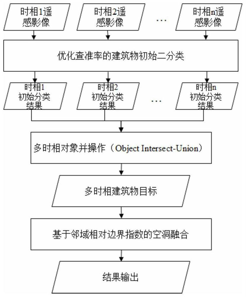
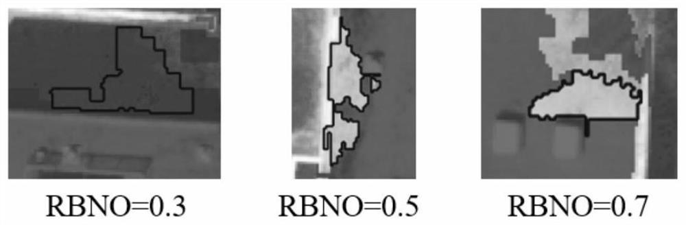
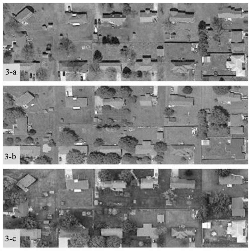
[0032] A building extraction optimization method based on multi-temporal images. Firstly, the initial binary classification is performed on the multi-temporal remote sensing images to optimize the precision rate. This step is to realize the binary classification process of buildings and non-buildings, and use texture, Geometric and area features reduce misclassification in the process of binary classification and prevent subsequent error expansion. Secondly, perform the intersection operation on the initial binary extraction results of multiple time phases, perform the intersection operation based on the pairwise results, and then perform the merge operation on the intersection results to realize the traversal of all time phase extraction results and prevent the extraction of a single image Errors, and realize the leak detection and filling of multi-temporal stable results. Finally, the non-building class is optimized by using the neighborhood relative boundary index to reduce...


PUM


Abstract

The invention discloses a building extraction optimization method based on a multi-temporal remote sensing image, and belongs to the technical field of satellite remote sensing image processing and application. The method comprises the following steps of: firstly, performing initial dichotomy of an optimized precision ratio on a multi-temporal remote sensing image, realizing a binary classification process of buildings and non-buildings, and reducing misclassification in the dichotomy process by adopting texture, geometry and area features; secondly, carrying out object intersection and union operation on the initial binary extraction results of the multiple time phases, carrying out union operation on intersection results, and traversing all time phase extraction results; and finally, optimizing the non-building class by using the neighborhood relative boundary index, and reducing cavity removal and edge vacancy in the building class. Experimental results of three-time-phase high-resolution remote sensing images show that the building recognition rate can be improved, noise interference of non-buildings can be reduced, a good extraction result is achieved, and compared with single recognition, the extraction precision is obviously improved.

Description

technical field [0001] The invention belongs to the technical field of satellite remote sensing image processing and application, and in particular relates to a building extraction optimization method based on multi-temporal remote sensing images. Background technique [0002] The use of remote sensing images for automatic and semi-automatic building extraction is of great significance. On the one hand, in the face of massively increased remote sensing image update data, building categories can be updated more quickly and efficiently, thereby contributing to the realization of digital earth and smart cities. Requirements for visualization and statistics of building categories. On the other hand, it can reduce the traditional manual visual interpretation work mode and reduce manpower and labor costs. [0003] However, existing methods still have many difficulties for building extraction. One of the notable difficulties is the occlusion of shadows of trees and tall buildings...

Claims


Application Information

Patent Timeline
IPC IPC(8): G06K9/00G06K9/62G06T7/10G06T7/181
CPCG06T7/10G06T7/181G06T2207/10032G06T2207/30181G06V20/176G06F18/24
Inventor 蒋圣谢乾朱乾安吴胤杰钱程乾张超戴琴陈海
Owner JIANGSU ZHUOYI INFORMATION TECH CO LTD
Why Eureka
Try Eureka