
Integrated navigation self-positioning method using inertial measurement unit and laser ranging

A laser ranging and autonomous positioning technology, applied in the field of navigation and guidance, can solve problems such as inability to work, radio signal interference, hidden dangers of aircraft weapons, etc., and achieve the effect of correcting speed and position errors, strong anti-interference ability, and eliminating susceptible to interference.

Active Publication Date: 2021-07-20
BEIJING LINJIN SPACE AIRCRAFT SYST ENG INST
View PDF4 Cites 0 Cited by
  • Summary
  • Abstract
  • Description
  • Claims
  • Application Information

AI Technical Summary

Problems solved by technology

However, radio signals are easily interfered by external electromagnetic signals. A satellite navigation jammer with a power of 1W can make satellite receivers within a distance of 85km unable to work, which brings hidden dangers to aircraft weapons using this composite guidance method.

Method used


Image

  • Integrated navigation self-positioning method using inertial measurement unit and laser ranging
  • Integrated navigation self-positioning method using inertial measurement unit and laser ranging
  • Integrated navigation self-positioning method using inertial measurement unit and laser ranging

Examples


Embodiment Construction

[0065] The present invention will be further elaborated below.

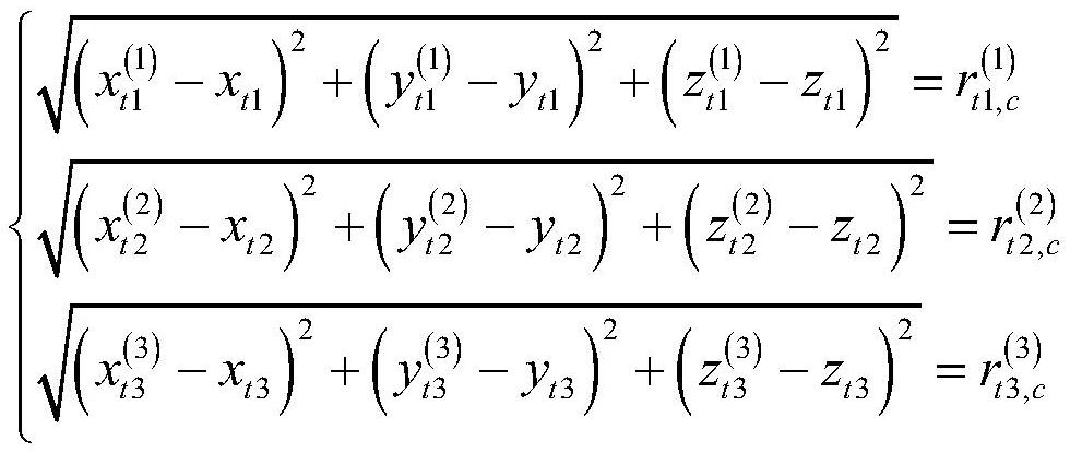
[0066] The invention proposes an autonomous positioning technology based on inertial group + laser ranging combined navigation. The aircraft emits laser light to measure the relative distance to the known inertial space position satellite, and calculates the difference with the position calculated by the inertial navigation, and corrects it through the combined navigation filter algorithm. Inertial navigation system error, improve the accuracy of aircraft navigation and guidance. This technology has independent anti-interference ability, and can realize high-precision positioning by observing the distance between the aircraft and known satellites in time-sharing without introducing satellite clock errors.

[0067] The inertial + laser ranging integrated navigation technology is similar to the INS + GPS tightly coupled combination mode, and the key point is to solve the integrated navigation problem when the numbe...


PUM


Abstract

The invention relates to an integrated navigation self-positioning method using an inertial measurement unit and laser ranging, which comprises the following steps of: firstly, formulating a time-sharing observation scheme by combining ephemeris information according to a flight profile task, and acquiring a geometric distance from an aircraft to an observation satellite; then obtaining an estimated value XStar=[xStar, yStar, zStar]<T> of an aircraft position given by a laser ranging navigation system under a navigation system through ranging information obtained by time-sharing observation; taking a foumula shown in the specification as a state quantity, establishing a kalman filtering equation according to an aircraft kinematic model, and introducing XStar into an observation equation to obtain an estimated value and a variance of the state quantity; and correcting a navigation result based on the inertial measurement unit by using the estimated value as an output value of combined navigation, so as to realize high-precision autonomous positioning of the aircraft. The method is high in measurement precision and good in directionality, and has autonomous anti-interference capability.

Description

technical field [0001] The invention belongs to the technical field of navigation and guidance, and relates to a combined navigation autonomous positioning method using inertial sets and laser ranging. Background technique [0002] The aircraft system generally adopts INS+GPS integrated navigation technology. The global satellite navigation system uses satellites to transmit radio codes, and the receiver performs ranging and positioning through the time delay of the radio codes. Information fusion with the inertial navigation system on the aircraft solves the problem of pure inertial navigation system errors accumulating or even diverging over time. However, radio signals are easily interfered by external electromagnetic signals. A satellite navigation jammer with a power of 1W can make satellite receivers within a range of 85km unable to work, which brings hidden dangers to aircraft weapons using this composite guidance method. Contents of the invention [0003] The tech...

Claims


Application Information

Patent Timeline
Patent Type & Authority Applications(China)
IPC IPC(8): G01C21/16G01C21/18G01C21/20G01S17/42
CPCG01C21/165G01C21/18G01C21/20G01S17/42
Inventor 陈政郭振西陈芳张箭飞武斌唐毛季登高陈志刚孙晓松巩英辉谢佳余颖韩伯雄刘辉杨丁
Owner BEIJING LINJIN SPACE AIRCRAFT SYST ENG INST
Learn More