Watershed scale vegetation net primary productivity remote sensing fine inversion method

A technology of net primary productivity and vegetation, applied in the field of remote sensing, can solve the problems of low resolution of net primary productivity products, inability to finely analyze watershed scales, and lack of fine inversion of NPP remote sensing, so as to improve estimation accuracy and product resolution. Effect

Inactive Publication Date: 2021-07-20
QINGDAO PROSPECTING INST OF GEOLOGICAL ENG
View PDF6 Cites 7 Cited by
  • Summary
  • Abstract
  • Description
  • Claims
  • Application Information

AI Technical Summary

Problems solved by technology

However, the area of ​​river basins is generally small, and more refined NPP inversion is required. However, most of the existing net primary productivity products have low resolution, and it is impossible to conduct fine analysis on the basin sca

Method used


Image

  • Watershed scale vegetation net primary productivity remote sensing fine inversion method
  • Watershed scale vegetation net primary productivity remote sensing fine inversion method
  • Watershed scale vegetation net primary productivity remote sensing fine inversion method

Examples


Embodiment Construction

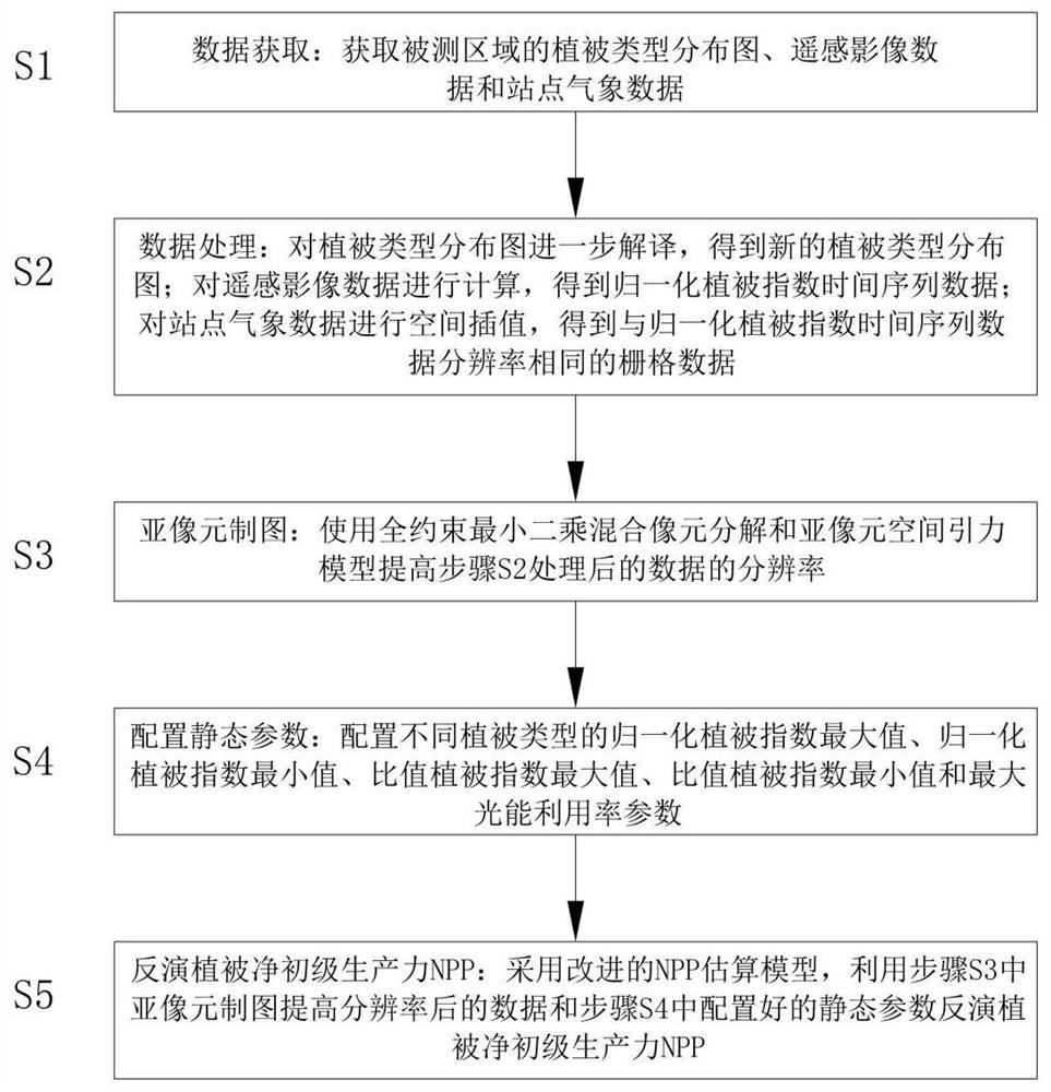
[0017] The following will clearly and completely describe the technical solutions in the embodiments of the present invention with reference to the accompanying drawings in the embodiments of the present invention. Obviously, the described embodiments are only some, not all, embodiments of the present invention. Based on the embodiments of the present invention, all other embodiments obtained by persons of ordinary skill in the art without making creative efforts belong to the protection scope of the present invention.

[0018] Such as figure 1 As shown in , a remote sensing fine inversion method for watershed-scale net primary productivity of vegetation includes the following steps:

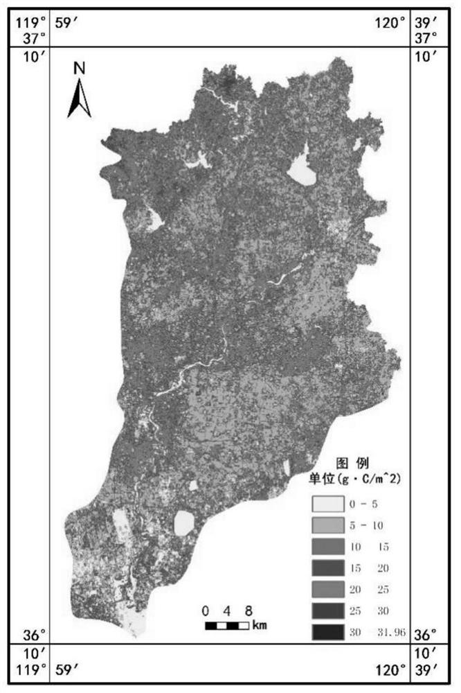
[0019] S1: Data acquisition: Taking the Dagu River area of ​​Qingdao as an example, the experiment was carried out through Landsat satellite data. The data size of the experimental area was 3588×2083 pixels, the resolution was 30 meters, and the acquisition time was 2018. Obtain vegetation type...


PUM


Abstract

The invention discloses a watershed scale vegetation net primary productivity remote sensing fine inversion method. The method comprises the following steps: acquiring a vegetation type distribution diagram, remote sensing image data and site meteorological data of a measured area; interpreting the vegetation type distribution diagram; calculating the remote sensing image data to obtain normalized vegetation index time sequence data; carrying out spatial interpolation on the station meteorological data to obtain raster data with the same resolution as the normalized vegetation index time sequence data; improving the resolution of the data by using a fully constrained least square mixed pixel decomposition and sub-pixel spatial gravitation model; configuring static parameters; and using the improved NPP estimation model to invert the vegetation net primary productivity NPP. On the basis of existing low-resolution remote sensing data, the method for improving the product resolution by means of sub-pixel mapping is provided, the vegetation net primary productivity is accurately estimated, the estimation precision of the net primary productivity is improved, and remote sensing fine inversion of the vegetation net primary productivity in the watershed scale is achieved.

Description

technical field [0001] The invention relates to the technical field of remote sensing, in particular to a fine inversion method for remote sensing of net primary productivity of watershed vegetation. Background technique [0002] Vegetation net primary productivity (NPP) not only directly reflects the production capacity of vegetation communities under natural environmental conditions, but also is the main factor for determining ecosystem carbon sources and carbon sinks and regulating ecological processes. Vegetation net primary productivity has been widely used in land use assessment, regional ecological planning, vegetation growth monitoring, crop yield estimation, soil and water erosion assessment, ecological benefit assessment, etc. [0003] The existing net primary productivity estimation models are roughly divided into four categories: climate productivity models, physiological and ecological process models, ecological remote sensing coupling models, and light energy u...

Claims


Application Information

Patent Timeline
IPC IPC(8): G06T3/40
CPCG06T3/4007G06T3/4053
Inventor 董杰刘洪华邢同菊王帅
Owner QINGDAO PROSPECTING INST OF GEOLOGICAL ENG
Why Eureka
Try Eureka