Elevation-based terrain detection algorithm

A technology of terrain detection and algorithm, which is applied in the field of terrain detection algorithm based on elevation, can solve the problems of distorted digital elevation model, imperfect filtering algorithm, inability to completely separate non-ground points, etc., and achieve simple logic structure and avoid missing occluders Effect

Active Publication Date: 2021-07-30
成都众享天地网络科技有限公司
View PDF16 Cites 4 Cited by
  • Summary
  • Abstract
  • Description
  • Claims
  • Application Information

AI Technical Summary

Problems solved by technology

[0007] The technical problem to be solved by the present invention is that the existing filtering algorithm is not perfect, and the non-ground points cannot be completely separated. These residual non-ground points show the characteristics of gross errors in the local terrain area, and the existence of gross errors will seriously distort the digital elevation model. It greatly affects the accuracy of the generated digital elevation model and makes it difficult for the operator to judge whether there is an obstacle between the radar and the target point. The purpose is to provide an elevation-based terrain detection algorithm to solve the above problems

Method used


Image

  • Elevation-based terrain detection algorithm

Examples


Embodiment

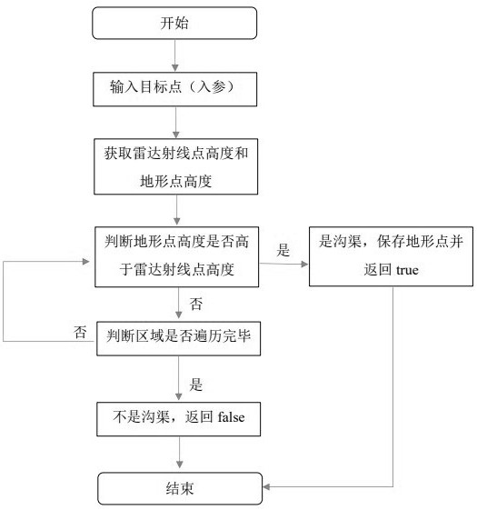
[0020] Such as figure 1 As shown, the present invention is an elevation-based terrain detection algorithm, and the algorithm includes the following steps: S1: After inputting the coordinate parameters of the target point, launch a radar ray from the launch point, and coordinate the area between the target point and the launch point Process to obtain the elevation data of the points on this ray; S2: Then project the points on the ray onto the terrain to obtain the topographic point data corresponding to the ray point, so as to obtain the height of each ray point and the height information of the topographic point; S3: Traverse the radar ray point height and terrain point height of the output coordinate point and target coordinate point in turn, and then judge whether the height of the terrain point is higher than the height of the radar ray point; S4: If the current terrain point is higher than the ray point, it means that the radar and the target If there is an occluder betwee...


PUM


Abstract

The invention discloses an elevation-based terrain detection algorithm, and the algorithm comprises the following steps: S1, transmitting a radar ray from a transmitting point after inputting the coordinate parameters of a target point, and carrying out coordinate processing on an area between the target point and the transmitting point, so as to obtain the elevation data of points on the ray; s2, projecting points on the ray to the terrain to obtain terrain point data corresponding to the ray points, so as to obtain the height of each ray point and the height information of the terrain points; s3, traversing the radar ray point height and the terrain point height of the output coordinate point and the target coordinate point in sequence, and then, judging whether the terrain point height is higher than the radar ray point height or not; s4, if the current terrain point is higher than the ray point, indicating that a shielding object exists between the radar and the target object, and at the moment, storing elevation data of the terrain point; and if the current terrain point is lower than the ray point, skipping the current terrain point.

Description

technical field [0001] The invention relates to a terrain detection algorithm, in particular to an elevation-based terrain detection algorithm. Background technique [0002] Digital Elevation Model (DEM, Digilal Elevation Model) is a spatial data model that describes surface relief features (regional geomorphology), and is represented by DEM unit grids. The DEM unit grid is described by a matrix composed of DEM data, and the DEM data includes plane coordinate (X, Y) data and elevation (Z) data. [0003] Radar can detect target objects by transmitting and receiving radio waves, for example, detecting the distance, azimuth, height, speed, shape and target type of the target object. When implementing detection, the radar detects by transmitting a radar beam and receiving the echo signal of the target object on the radar beam. In the echo signal, in addition to the echo signal (radio wave) reflected by the target object, part of the radar beam will also touch the ground during...

Claims


Application Information

Patent Timeline
Patent Type & Authority Applications(China)
IPC IPC(8): G01S7/41G01C5/00
CPCG01C5/00G01S7/411
Inventor 孙成刚岳红霞张剑锋潘宝凤谢勇蒋伟唐庆生
Owner 成都众享天地网络科技有限公司
Why Eureka
Try Eureka