Automatic reservoir surveying and mapping system and method for surveying and mapping geographic information

A technology for surveying and mapping geography and reservoirs, which is applied in the field of reservoir geographic information surveying and mapping, can solve problems such as time delay, large cycle, and large number of mountains, and achieve the effects of shortening the measurement cycle, reducing work intensity, and improving measurement efficiency

Pending Publication Date: 2021-11-16
王坤
View PDF0 Cites 1 Cited by
  • Summary
  • Abstract
  • Description
  • Claims
  • Application Information

AI Technical Summary

Problems solved by technology

At present, the tripod measurement equipment is mainly used to measure the displacement of the mountain. However, although the tripod measurement equipment can be used to survey and map the mountain, in the actual surveying and mapping process, the surveyors and mappers reflect the following technical defects: 1. The mountain involved The quantity is large, so the equipment needs to be moved constantly, which undoubtedly increases the work intensity of the surveyors
2. The measured data can only be fed back to the upper-level leaders after being recorded and reviewed, which is too time-consuming and the cycle is too long, which reduces the measurement efficiency of mountain displacement
3. Under bad weather conditions, such as heavy rain, dark weather, etc., which block the view of the surveyors and mappers, the surveying and mapping cannot be carried out normally, so the mountain displacement cannot be surveyed and mapped in time, which further reduces the measurement efficiency of the mountain displacement
4. Among the existing surveying and mapping equipment, there is no surveying and mapping equipment that can directly measure the displacement of the reservoir bottom, which has certain limitations

Method used


Image

  • Automatic reservoir surveying and mapping system and method for surveying and mapping geographic information
  • Automatic reservoir surveying and mapping system and method for surveying and mapping geographic information
  • Automatic reservoir surveying and mapping system and method for surveying and mapping geographic information

Examples


Embodiment Construction

[0044] The present invention will be further described below in conjunction with accompanying drawing, protection scope of the present invention is not limited to the following:

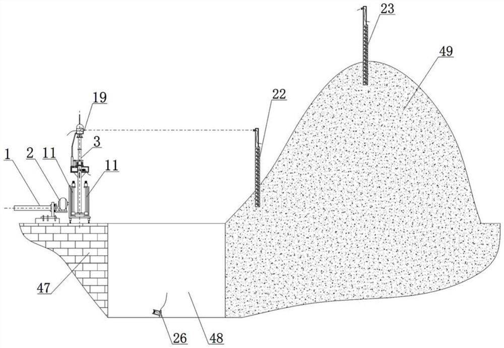
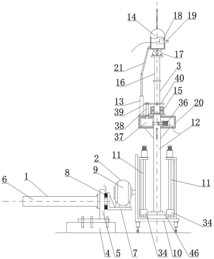
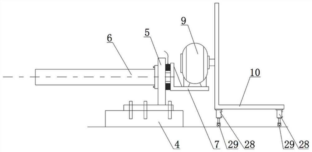
[0045] Such as Figure 1-8 As shown, an automatic surveying and mapping system for water reservoirs for surveying and mapping geographical information includes a linear conveying mechanism 1, a rotating mechanism 2 and a measuring actuator 3, and the linear conveying mechanism 1 includes a cement base 4 fixed on the top surface of a dam 47 , the installation seat 5 fixed on the top surface of the cement machine base 4, the feed oil cylinder 6 fixed on the installation seat 5, the piston rod of the feed cylinder 6 is set towards the reservoir 48, and the action end of the piston rod is fixedly provided with L plate 7, an annular electromagnet 8 is fixed on the end surface of the mounting seat 5, the vertical plate of the L plate 7 is adsorbed on the end surface of the annular electromagnet 8, and the ...


PUM


Abstract

The invention discloses an automatic reservoir surveying and mapping system for surveying and mapping geographic information, which comprises a linear conveying mechanism, a rotating mechanism and a measurement executing mechanism, and is characterized in that the linear conveying mechanism comprises a cement engine base fixedly arranged on the top surface of a water dam, a mounting base fixedly arranged on the top surface of the cement engine base, and a feeding oil cylinder fixedly arranged on the mounting base; a vertical plate of the L-shaped plate is adsorbed on the end surface of the annular electromagnet; the rotating mechanism comprises a hydraulic motor and a rack, the hydraulic motor is fixedly arranged on the top surface of a horizontal plate of the L-shaped plate, the left end of the rack is welded to an output shaft of the hydraulic motor, and a linear driving mechanism is arranged on the rack; and the measurement executing mechanism is arranged on a moving part of the linear driving mechanism and comprises a stand column, a lifting oil cylinder and a pitching machine shell. The method has the beneficial effects that the displacement of the reservoir bottom can be measured, the mountain displacement measurement efficiency is improved, the method is suitable for measurement in severe weather, and the working intensity of survey personnel is relieved.

Description

technical field [0001] The invention relates to the technical field of reservoir geographical information surveying and mapping, in particular to an automatic surveying and mapping system and method for surveying and mapping geographical information water reservoirs. Background technique [0002] Reservoirs include dams and mountains distributed upstream of the dams. Reservoirs are formed between dams and mountains. Among them, dams are water-retaining structures that intercept the water flow of river channels to raise water levels or regulate flow. Raise water levels, regulate runoff, and concentrate water heads. , used for flood control, water supply, irrigation, hydroelectric power generation, improvement of navigation, etc., to adjust the river regime and protect the bank bed. [0003] In recent years, due to changes in the natural environment, natural disasters such as landslides, mudslides, landslides, ground subsidence, and earthquakes have occurred frequently, result...

Claims


Application Information

Patent Timeline
Patent Type & Authority Applications(China)
IPC IPC(8): G01B11/02
CPCG01B11/02
Inventor 王坤
Owner 王坤
Why Eureka
Try Eureka