Pavement subsidence detection method and device based on satellite and unmanned aerial vehicle remote sensing

A road surface detection and remote sensing technology, applied in measurement devices, radio wave measurement systems, surveying and navigation, etc., can solve problems such as lack of integration, and achieve the effects of rapid detection, reduction of manual field operations, and high detection efficiency.

Pending Publication Date: 2021-12-17
SOUTHEAST UNIV
View PDF10 Cites 6 Cited by
  • Summary
  • Abstract
  • Description
  • Claims
  • Application Information

AI Technical Summary

Problems solved by technology

At this stage, the research on InSAR technology and UAV remote sensing detection is isolated, and there is no example of effective combination of the two

Method used


Image

  • Pavement subsidence detection method and device based on satellite and unmanned aerial vehicle remote sensing
  • Pavement subsidence detection method and device based on satellite and unmanned aerial vehicle remote sensing
  • Pavement subsidence detection method and device based on satellite and unmanned aerial vehicle remote sensing

Examples


Embodiment Construction

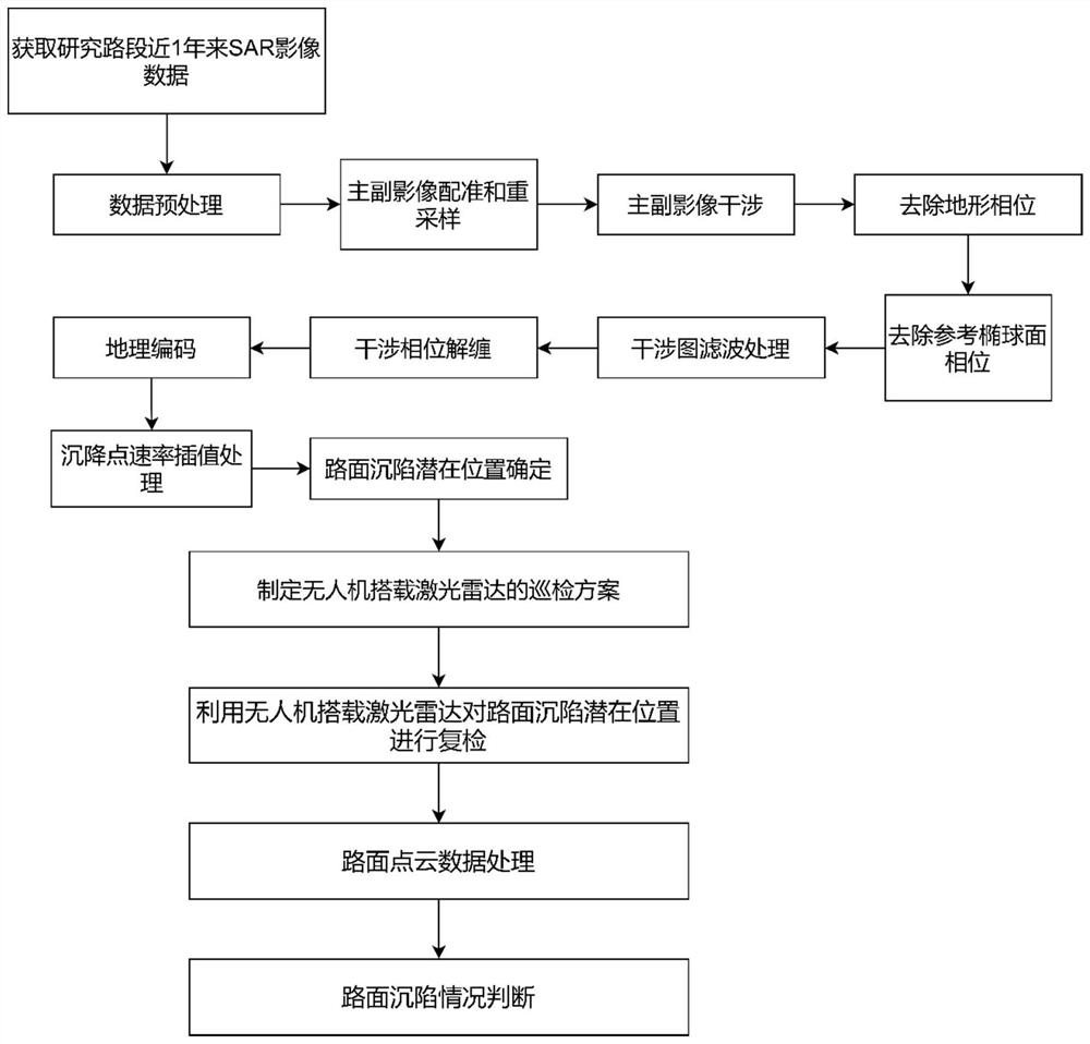
[0064] In order to make the purpose and technical solutions of the embodiments of the present invention more clear, the technical solutions of the embodiments of the present invention will be clearly and completely described below in conjunction with the drawings of the embodiments of the present invention. Apparently, the described embodiments are some, not all, embodiments of the present invention. Based on the described embodiments of the present invention, all other embodiments obtained by persons of ordinary skill in the art without creative efforts shall fall within the protection scope of the present invention.

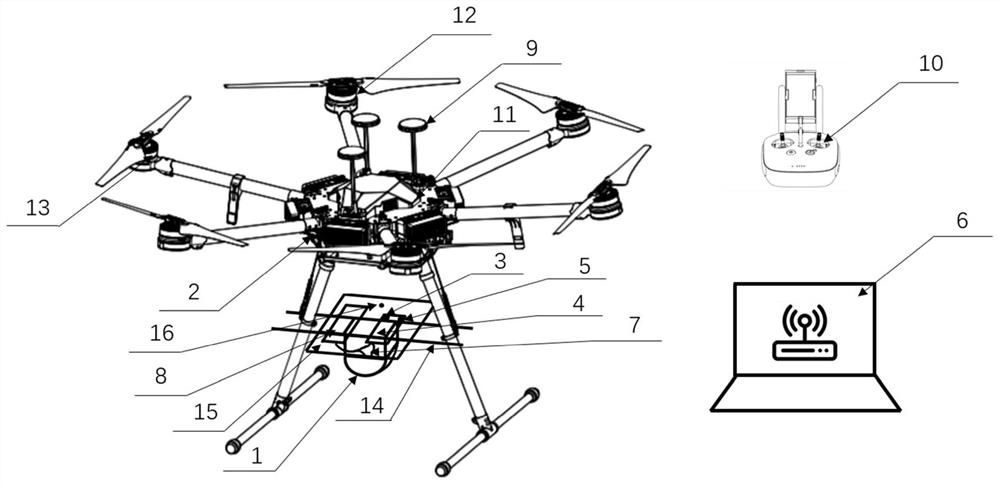
[0065] Such as figure 1 As shown, a road surface subsidence detection device equipped with a laser radar for a drone includes a laser radar 1; a drone body 2; a wireless data transmission module 3; a raspberry pie 4; a MicroSD memory card 5; a computer 6; a data line 7 ; DC power supply 8; GPS data module 9; wireless remote controller 10; flight control unit 1...


PUM


Abstract

The invention relates to the technical field of road disease detection, in particular to a pavement subsidence detection method and device based on satellite and unmanned aerial vehicle remote sensing. The method comprises the following steps of: acquiring original SAR image data of a to-be-detected road section; extracting sedimentation rate information; determining a potential occurrence position of pavement subsidence; making an inspection scheme of an unmanned aerial vehicle carrying a laser radar for reinspection; conducting road surface point cloud data processing; and judging the subsidence condition of a pavement. According to the pavement subsidence detection device and method based on satellite and unmanned aerial vehicle remote sensing, the potential position where pavement subsidence possibly occurs is found out according to the subsidence rate distribution condition, preliminary detection of pavement subsidence is achieved within a large range, the advantages of the InSAR technology are fully utilized, and manual field operation is reduced; and rapid detection of pavement subsidence is realized, the detection method is innovative, and the detection efficiency is relatively high.

Description

technical field [0001] The invention relates to the technical field of road disease detection, in particular to a road surface subsidence detection method and device based on satellite and UAV remote sensing. Background technique [0002] Pavement subsidence refers to the phenomenon that the road surface sinks due to the vertical deformation of the roadbed. When the driving vehicle passes through subsidence, a large impact load is generated, and the vehicle appears "bumping", which seriously affects the safety and comfort of the road, and reduces the performance and service level of the road. If the subsidence of the road surface is not maintained in time, the subsidence area will develop rapidly, and the downward development will cause damage to the grassroots and even the roadbed. "Highway Technical Condition Evaluation Standard" JTG5210-2018 defines road subsidence as local subsidence of the road surface greater than 10mm, providing a basis for its rapid detection. The ...

Claims


Application Information

Patent Timeline
Patent Type & Authority Applications(China)
IPC IPC(8): G01C5/00G01S17/90G06T5/00G06T5/20G06T7/00G06T7/73
CPCG01C5/00G01S17/90G06T7/0002G06T7/73G06T5/002G06T5/20G06T2207/10044G06T2207/10028
Inventor 朱俊清崔亮马涛
Owner SOUTHEAST UNIV
Why Eureka
Try Eureka