Method for obtaining water quality total phosphorus parameter inversion optimal model based on satellite data

A satellite data and optimal model technology, applied in the field of satellite remote sensing data processing, can solve the problems of small range, large consumption of manpower, material and financial resources, and limited number of water sample collection and analysis, so as to achieve real-time monitoring and reduce time-consuming strenuous effect

Active Publication Date: 2022-01-18
江苏天汇空间信息研究院有限公司
View PDF5 Cites 0 Cited by
  • Summary
  • Abstract
  • Description
  • Claims
  • Application Information

AI Technical Summary

Problems solved by technology

[0002] The traditional water quality total phosphorus monitoring method generally adopts on-site sampling and analysis, and then conducts laboratory analysis on the samples; because the data taken by this method can only represent the water quality of the collection section at the moment of collection, it is difficult to obtain large-scale, wide-area, quasi-real-time water bodies The spatial distribution of water quality and the trend of change, the data obtained often have the disadvantages of discontinuity in time and space, small range, and limited number of water samples collected and analyzed. Therefore, the monitoring results obtained by traditional water quality total phosphorus monitoring methods have only partial And typical representative significance, can not meet the large-scale and real-time water quality total phosphorus monitoring requirements;
[0003] The traditional water quality total phosphorus monitoring method consumes a lot of manpower, material resources and financial resources, and this method is highly dependent on the station monitoring instruments, which requires regular inspection and maintenance of the station monitoring instruments to avoid the impact of instrument failure on the monitoring of the total phosphorus concentration , so it also has the disadvantages of cumbersome operation and consuming a lot of financial and material resources

Method used


Image

  • Method for obtaining water quality total phosphorus parameter inversion optimal model based on satellite data
  • Method for obtaining water quality total phosphorus parameter inversion optimal model based on satellite data
  • Method for obtaining water quality total phosphorus parameter inversion optimal model based on satellite data

Examples


Embodiment Construction

[0061] The following will clearly and completely describe the technical solutions in the embodiments of the present invention with reference to the accompanying drawings in the embodiments of the present invention. Obviously, the described embodiments are only some, not all, embodiments of the present invention. Based on the embodiments of the present invention, all other embodiments obtained by persons of ordinary skill in the art without making creative efforts belong to the protection scope of the present invention.

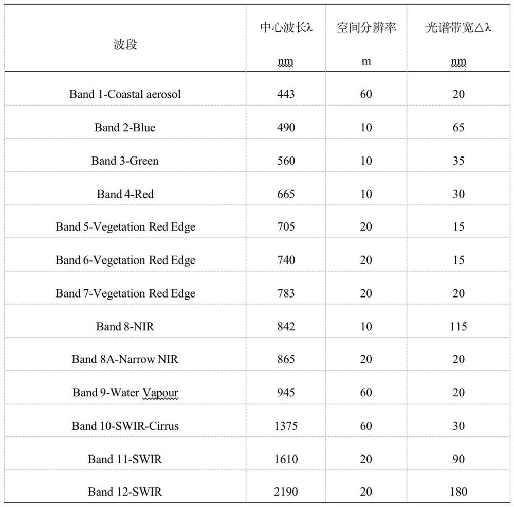
[0062] The term "Sentinel-2 L2A level data" is used in this article. The Sentinel-2A satellite was developed by the European Space Agency and was launched on June 23, 2015. The data has the advantages of high spatial resolution, strong multispectral imaging capability, wide swath, and short revisit cycle. It can be used to monitor changes in the earth's land cover, vegetation health, and water pollution, as well as to monitor natural disasters such as landslide...


PUM


Abstract

The invention discloses a method for obtaining a water quality total phosphorus parameter inversion optimal model based on satellite data, and the method comprises the steps: S100 extracting sentinel No.2 L2A-level data according to demands, and carrying out the data preprocessing of the data; S200 extracting the reflectivity of the remote sensing wave band of each point according to the longitude and latitude data of the actually measured point; S300 carrying out correlation analysis on the extracted reflectivity of each wave band of each calibrated water body point location and total phosphorus concentration data measured by each water quality monitor on site; screening out each wave band or each combined wave band greater than a correlation threshold value from a correlation calculation result; S400 respectively establishing different regression models based on different correlation analyses, wherein the regression model comprises but is not limited to a single-band regression model and a multi-band combined regression model; and S500 performing error analysis on different regression models, and determining an inversion optimal model based on an error analysis result.

Description

technical field [0001] The invention relates to the technical field of satellite remote sensing data processing, in particular to a method for obtaining an optimal model for water quality total phosphorus parameter inversion based on satellite data. Background technique [0002] The traditional water quality total phosphorus monitoring method generally adopts on-site sampling and analysis, and then conducts laboratory analysis on the samples; because the data taken by this method can only represent the water quality of the collection section at the moment of collection, it is difficult to obtain large-scale, wide-area, quasi-real-time water bodies The spatial distribution of water quality and the trend of change, the data obtained often have the disadvantages of discontinuity in time and space, small range, and limited number of water samples collected and analyzed. Therefore, the monitoring results obtained by traditional water quality total phosphorus monitoring methods hav...

Claims


Application Information

Patent Timeline
IPC IPC(8): G01N21/27G06F30/20G06F119/02
CPCG01N21/27G06F30/20G01N2021/1765G01N2021/1793G06F2119/02Y02A20/152
Inventor 姚千禧陈燕婕曹洪涛顾行发余涛刘向东黄祥志
Owner 江苏天汇空间信息研究院有限公司
Why Eureka
Try Eureka