Supercharge Your Innovation With Domain-Expert AI Agents!

Unmanned aerial vehicle surveying and mapping measurement service management device

A management device and measurement service technology, applied in the field of UAV surveying and mapping, can solve the problems of cumbersome measurement process, poor anti-interference ability, complicated preparation work, etc., to achieve the effect of simple layout, improved practicability, and high detection efficiency

Inactive Publication Date: 2022-01-28
李庆胜
View PDF0 Cites 0 Cited by
  • Summary
  • Abstract
  • Description
  • Claims
  • Application Information

AI Technical Summary

Problems solved by technology

With the development of science and technology, the tools used in surveying and mapping are becoming more and more intelligent, based on computer technology, photoelectric technology, network communication technology, space science, information science, and based on global navigation satellite positioning system, remote sensing, geographic information system, etc. As the core of the technology, the existing feature points and boundaries on the ground are selected and the graphics and position information reflecting the current situation of the ground are obtained by means of measurement. However, the current pre-measurement preparation work is complicated, the measurement cost is high, and the measurement accuracy is limited by the measurement site. The number of marked points is collected on the reference point, and the measurement process is cumbersome, requiring actual surveyors to place measurement facilities multiple times, and the anti-interference ability is poor

Method used


Image

  • Unmanned aerial vehicle surveying and mapping measurement service management device
  • Unmanned aerial vehicle surveying and mapping measurement service management device

Examples


Embodiment Construction

[0022] The technical solution of this patent will be further described in detail below in conjunction with specific embodiments.

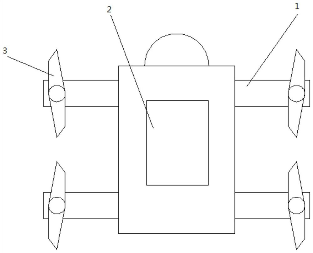
[0023] An unmanned aerial vehicle surveying and mapping measurement service management device and inspection method, including a frame 1 and a host 2, the frame 1 is surrounded by aircraft 3, and the host 2 is arranged in the middle of the frame 1;

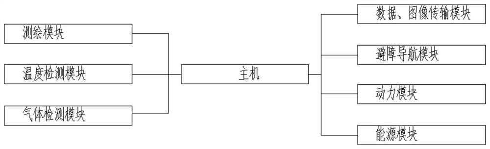
[0024] The host 2 includes a surveying and mapping module, a temperature detection module, a gas detection module, a data and image transmission module, an obstacle avoidance navigation module, a power module, and an energy module.

[0025] Furthermore, the frame adopts lightweight carbon fiber material as the main material.

[0026] Further, the surveying and mapping module includes: a laser scanner and a digital aerial camera, and obtains the coordinates (X, Y, Z);

[0027] Data and image transmission module: The image data transmission module through point-to-point transmission, including hardware...


PUM


Abstract

The invention discloses an unmanned aerial vehicle surveying and mapping measurement service management device and an inspection method, the device comprises a rack and a host, aircrafts are arranged around the rack, and the host is arranged in the middle of the rack; the surveying and mapping module, the temperature detection module, the gas detection module, the data and image transmission module, the obstacle avoidance navigation module, the power module and the energy module can realize automatic surveying and mapping, only intelligent terminal control is needed, the labor cost is greatly saved, and the practicability of the device is improved; the detection efficiency is higher, the layout is simple, and the adaptability and the flexibility are higher.

Description

technical field [0001] The present invention relates to the technical field of unmanned aerial vehicle surveying and mapping, and in particular, relates to an unmanned aerial vehicle surveying and mapping measurement service management device. Background technique [0002] Surveying and mapping refers to the measurement, collection and drawing of the shape, size, spatial location and attributes of natural geographical elements or surface artificial facilities. With the development of science and technology, the tools used in surveying and mapping are becoming more and more intelligent, based on computer technology, photoelectric technology, network communication technology, space science, information science, and based on global navigation satellite positioning system, remote sensing, geographic information system, etc. As the core of the technology, the existing feature points and boundaries on the ground are selected and the graphics and position information reflecting the...

Claims


Application Information

Patent Timeline
Patent Type & Authority Applications(China)
IPC IPC(8): G01C11/02G01K13/00G01N33/00G01S17/933G01B11/00B64D47/08B64D47/00B64C39/02B64C1/00
CPCG01C11/02G01S17/933G01N33/0009G01K13/00G01B11/002B64C1/00B64D47/08B64D47/00B64C39/024B64C2001/0072B64U2101/30
Inventor 李庆胜费文华周停停
Owner 李庆胜
Features
  • R&D
  • Intellectual Property
  • Life Sciences
  • Materials
  • Tech Scout
  • Unparalleled Data Quality
  • Higher Quality Content
  • 60% Fewer Hallucinations
Learn More