Unlock instant, AI-driven research and patent intelligence for your innovation.

Laser radar-inertial navigation combined calibration system and method and medium

A laser radar and joint calibration technology, applied in the field of laser radar-inertial navigation joint calibration system, can solve problems such as inconsistent time axis and inconsistent space coordinates, reduce personnel risks, have a wide range of applications, and eliminate point cloud motion distortion Effect

Pending Publication Date: 2022-02-25
DONGFENG OFF ROAD VEHICLE CO LTD
View PDF0 Cites 0 Cited by
  • Summary
  • Abstract
  • Description
  • Claims
  • Application Information

AI Technical Summary

Problems solved by technology

[0004] The present invention aims to solve the problems of inconsistent spatial coordinates and inconsistent time axes, and proposes a joint calibration system, method and medium based on laser radar-inertial navigation that converts the laser radar coordinate system to the vehicle body coordinate system

Method used


Image

  • Laser radar-inertial navigation combined calibration system and method and medium
  • Laser radar-inertial navigation combined calibration system and method and medium
  • Laser radar-inertial navigation combined calibration system and method and medium

Examples


Embodiment Construction

[0051] The following specific implementation methods are used to explain the technical solutions of the claims of the present invention, so that those skilled in the art can understand the claims. The protection scope of the present invention is not limited to the following specific implementation structures. The protection scope of the present invention includes the technical solution of the claims of the present invention made by those skilled in the art and is different from the following specific embodiments.

[0052] In addition, in the description of the present invention, the terms "first", "second" and so on are only used to distinguish descriptions, and should not be understood as indicating or implying relative importance.

[0053] First, some nouns and parameters involved in this application are introduced.

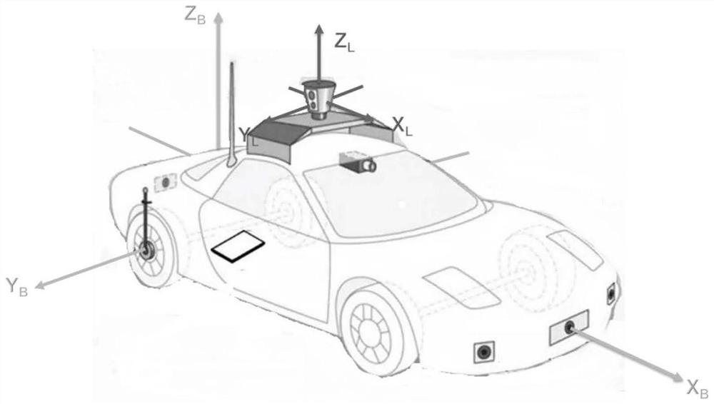
[0054] In this embodiment, all pose transformation matrices T are defined as shown in formula 1-1, which directly represents the rotation and translation tran...


PUM


Abstract

The invention discloses a laser radar-inertial navigation joint calibration system and method and a medium. The laser radar-inertial navigation joint calibration system comprises a first coordinate conversion module and a motion distortion elimination module, and the first coordinate conversion module is used for converting coordinates of point cloud data output by a radar from a radar coordinate system to a vehicle body coordinate system; and the motion distortion elimination module is used for converting coordinates of each part of radar point cloud data generated at different moments after being converted to the vehicle body coordinate system into the vehicle body coordinate system at corresponding moments through calculation according to multi-frame pose information generated by inertial navigation in adjacent working periods of the radar. By utilizing the system and the method disclosed by the invention, the time synchronism and accuracy of the point cloud data and the inertial navigation data can be ensured, the point cloud motion distortion caused by the motion of the intelligent vehicle is eliminated, and meanwhile, the problem of equipment load caused by large data calculation amount in engineering application is also considered.

Description

technical field [0001] The invention belongs to the technical field of autonomous navigation for intelligent driving, and in particular relates to a laser radar-inertial navigation joint calibration system, method and medium. Background technique [0002] With the development of intelligent driving technology, various sensors such as lidar, inertial navigation and other equipment are often used as the "eyes" of intelligent vehicles to obtain environmental information and the state of intelligent vehicles themselves, which is the prerequisite for intelligent vehicles to achieve autonomous behavior. It is widely used in unmanned driving of vehicles or assisted driving of vehicles. The perception and positioning of a single sensor are all in the coordinate system of each sensor. There are problems of inconsistent spatial coordinates and inconsistent time axes. It is necessary to convert the coordinates to ensure that all data are expressed in a unified spatial coordinate system...

Claims


Application Information

Patent Timeline
IPC IPC(8): G01S7/497G01C25/00
CPCG01S7/497G01C25/005
Inventor 孟宵谢国法王斌刘威姚本容
Owner DONGFENG OFF ROAD VEHICLE CO LTD
Features
  • R&D
  • Intellectual Property
  • Life Sciences
  • Materials
  • Tech Scout
  • Unparalleled Data Quality
  • Higher Quality Content
  • 60% Fewer Hallucinations
Learn More