Monthly-scale satellite-ground precipitation fusion method based on random forest and land surface environment variables

A technology of environmental variables and random forests, applied in machine learning, computer components, instruments, etc., can solve problems such as multi-collinear model errors, and achieve the effects of high precision, small errors, and less calculation

Pending Publication Date: 2022-04-19
HOHAI UNIV
View PDF0 Cites 2 Cited by
  • Summary
  • Abstract
  • Description
  • Claims
  • Application Information

AI Technical Summary

Problems solved by technology

However, this method may have multicollinearity of indep...

Method used


Image

  • Monthly-scale satellite-ground precipitation fusion method based on random forest and land surface environment variables
  • Monthly-scale satellite-ground precipitation fusion method based on random forest and land surface environment variables

Examples


Embodiment 1

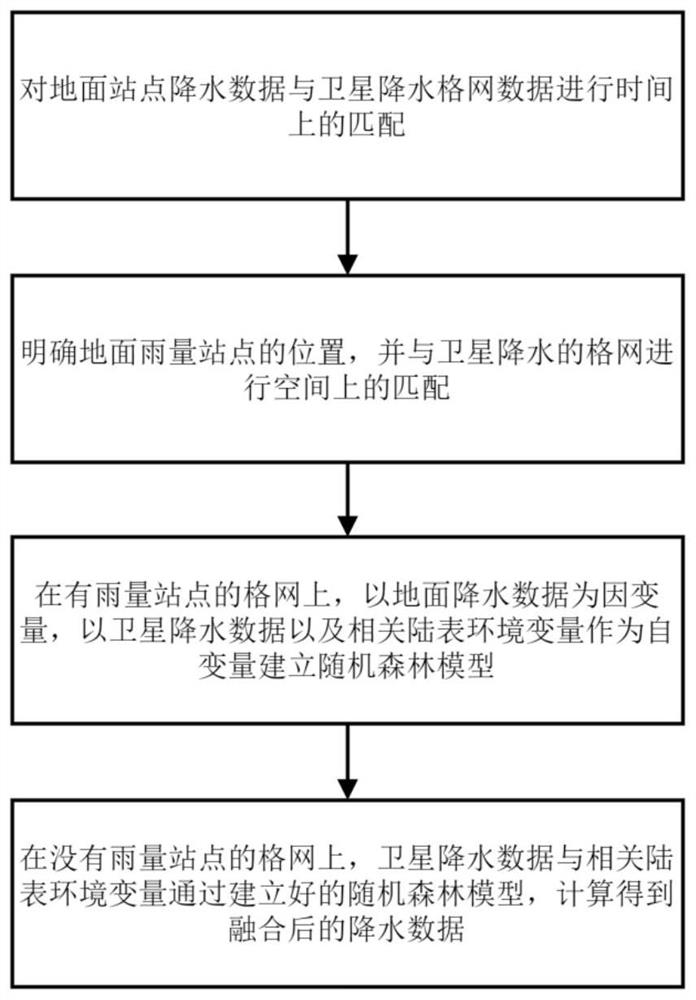
[0021] refer to figure 1 , Embodiment 1 of the present invention comprises the following steps:

[0022] Step 1, time-matching the precipitation data of the ground station and the satellite precipitation grid data;

[0023] Step 2, specify the location of the surface rainfall station, and spatially match it with the satellite precipitation grid;

[0024] Step 3: On the grid with rainfall stations, a random forest model is established with surface precipitation data as the dependent variable and satellite precipitation data and related land surface environmental variables as independent variables;

[0025] Step 4: On the grid without rainfall stations, the satellite precipitation data and related land surface environmental variables are calculated through the established random forest model to obtain the fused precipitation data.

Embodiment

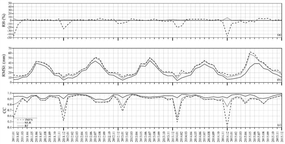
[0026] Embodiment: Select satellite daily precipitation data to be the TMPA daily data of 2011-2015, have the spatial resolution of 0.25 °; The daily precipitation observation data of meteorological station comes from China Meteorological Administration, there are more than 2000 weather stations in the study area Station; environmental variables used: digital elevation model (DEM), normalized difference vegetation index (NDVI), land surface temperature (LST, including daytime surface temperature and nighttime surface temperature), longitude and latitude. Among them, the DEM data comes from SRTM with a spatial resolution of 90 meters; the NDVI data comes from NASA’s MOD13C2 product, which is a monthly synthesized NDVI index with a spatial resolution of 0.05°; the LST data comes from NASA’s MOD11C3 product, which is Monthly synthesized LST with 0.05° spatial resolution;

[0027] Since the present invention uses all the rainfall stations to participate in the fusion, there is no ...


PUM


Abstract

The invention discloses a monthly-scale satellite-ground precipitation fusion method based on a random forest and a land surface environment variable, and the method comprises the following steps: firstly, carrying out the time matching of ground station precipitation data and satellite precipitation grid data; secondly, determining the position of a ground rainfall site, and matching the ground rainfall site with a grid of satellite rainfall in space; thirdly, establishing a random forest model on the grids with rainfall sites by taking the ground rainfall data as dependent variables and taking the satellite rainfall data and related land surface environment variables as independent variables; and finally, on the grid without rainfall sites, calculating the satellite rainfall data and the related land surface environment variables through the established random forest model to obtain fused rainfall data. According to the method, the land surface environment variables related to rainfall are combined, the ground rainfall and the satellite rainfall are fused, high-precision fused rainfall data are obtained, and a rainfall input source with higher precision can be provided for a hydrological model and the like.

Description

technical field [0001] The invention relates to a multi-source precipitation data fusion method, in particular to a monthly-scale satellite-earth precipitation fusion method based on random forests and land surface environmental variables that can reduce errors. Background technique [0002] As a common natural phenomenon, precipitation plays an important role in global water cycle, ecosystem, climate system and energy balance. The temporal and spatial distribution of precipitation directly or indirectly affects terrestrial hydrological processes such as surface runoff, groundwater dynamics, soil moisture, and evapotranspiration, and is therefore an important parameter in hydrology, meteorology, and ecology. At the same time, precipitation enables moisture in the atmosphere to return to the ground, providing fresh water resources for the survival of life on earth. Therefore, reliable and accurate precipitation measurement is not only crucial to understanding climate change,...

Claims


Application Information

Patent Timeline
IPC IPC(8): G06K9/62G06N20/00
CPCG06N20/00G06F18/25
Inventor 沈哲辉雍斌吴昊周泽慧丁明泽
Owner HOHAI UNIV
Why Eureka
Try Eureka