Soil moisture monitoring microwave radiometer method

A microwave radiometer and soil moisture technology, which is applied in the field of microwave remote sensing technology, can solve the problems of water content changes in vegetation layers, the inability to guarantee the time synchronization between auxiliary data and microwave radiometer observation data, and difficulty in obtaining and updating auxiliary data.

Inactive Publication Date: 2006-10-18
REMOTE SENSING APPLIED INST CHINESE ACAD OF SCI
View PDF0 Cites 22 Cited by
  • Summary
  • Abstract
  • Description
  • Claims
  • Application Information

AI Technical Summary

Problems solved by technology

[0005] The biggest problem existing in the calculation of the opacity of the vegetation layer in the existing technology is that it is difficult to obtain and update the auxiliary data in time, and only empirical values ​​can be substituted into the calculation, and the time synchronization between the auxiliary data and the observation data of the microwave radiometer cannot be guaranteed.
For example, the parameter b is determined according to the ground vegetation classification data, but in practice this parameter will change with the vegetation growth, and there are differences in this value when observed at different frequencies; ω as the water content of the vegetation layer will change with the Changes with seasons and precipitation
Both the b and ω values ​​in the empirical calculation formula have time and climate variability, and using fixed values ​​to describe the opacity of the vegetation layer during radiometer observation cannot fully reflect the influence of vegetation on the surface radiation at the time of radiometer observation

Method used


Image

  • Soil moisture monitoring microwave radiometer method
  • Soil moisture monitoring microwave radiometer method
  • Soil moisture monitoring microwave radiometer method

Examples


Embodiment Construction

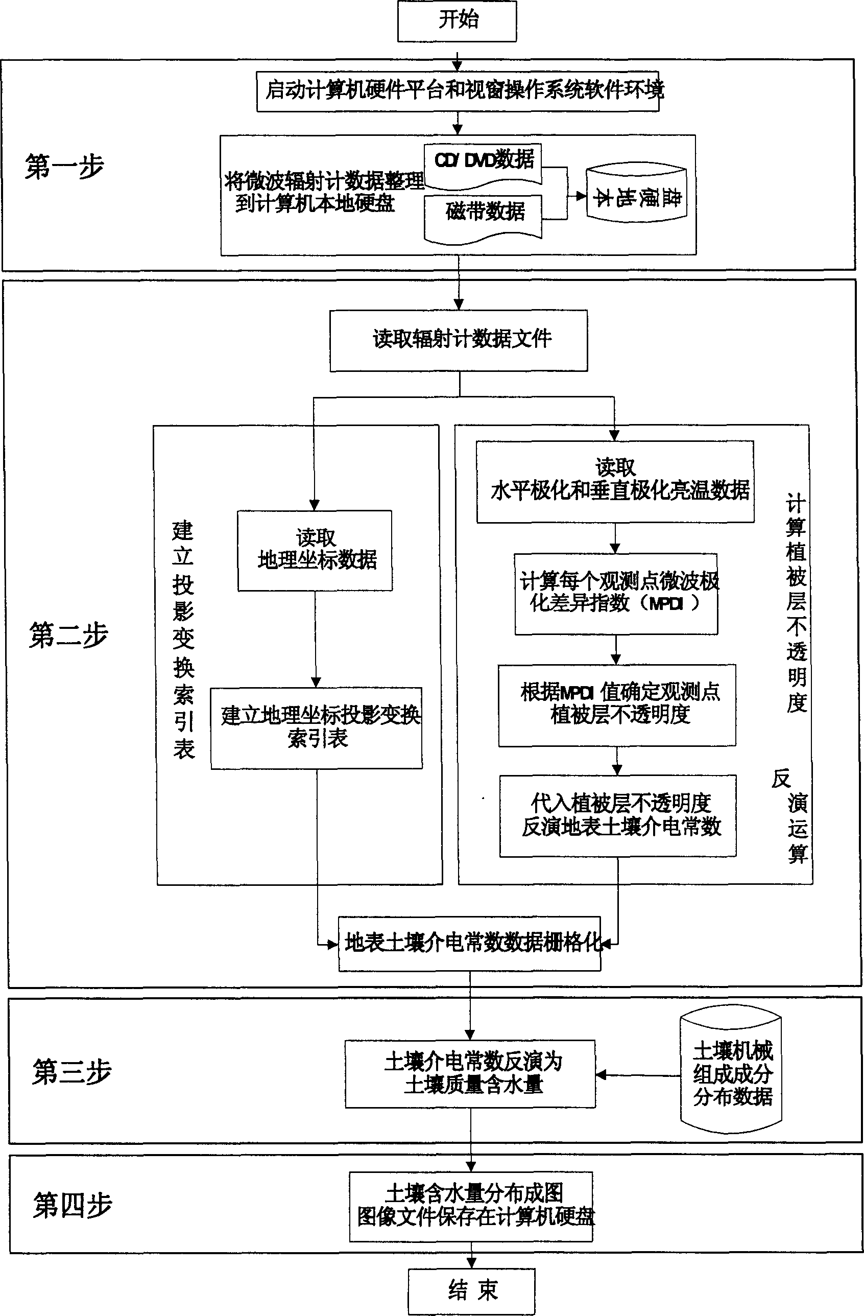
[0013] figure 1 The method of retrieving soil moisture from microwave radiometer data is as follows:

[0014] The inversion work takes the microcomputer as the physical platform and the Microsoft Windows system as the software system environment. The operation process can be divided into four steps:

[0015] The first step is to prepare the operating environment and radiometer data;

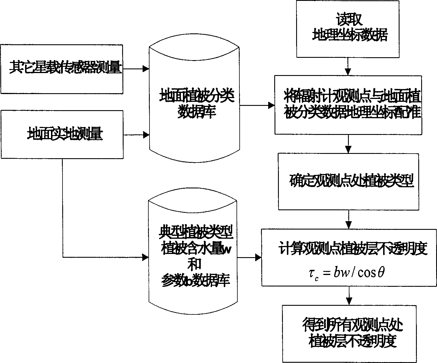
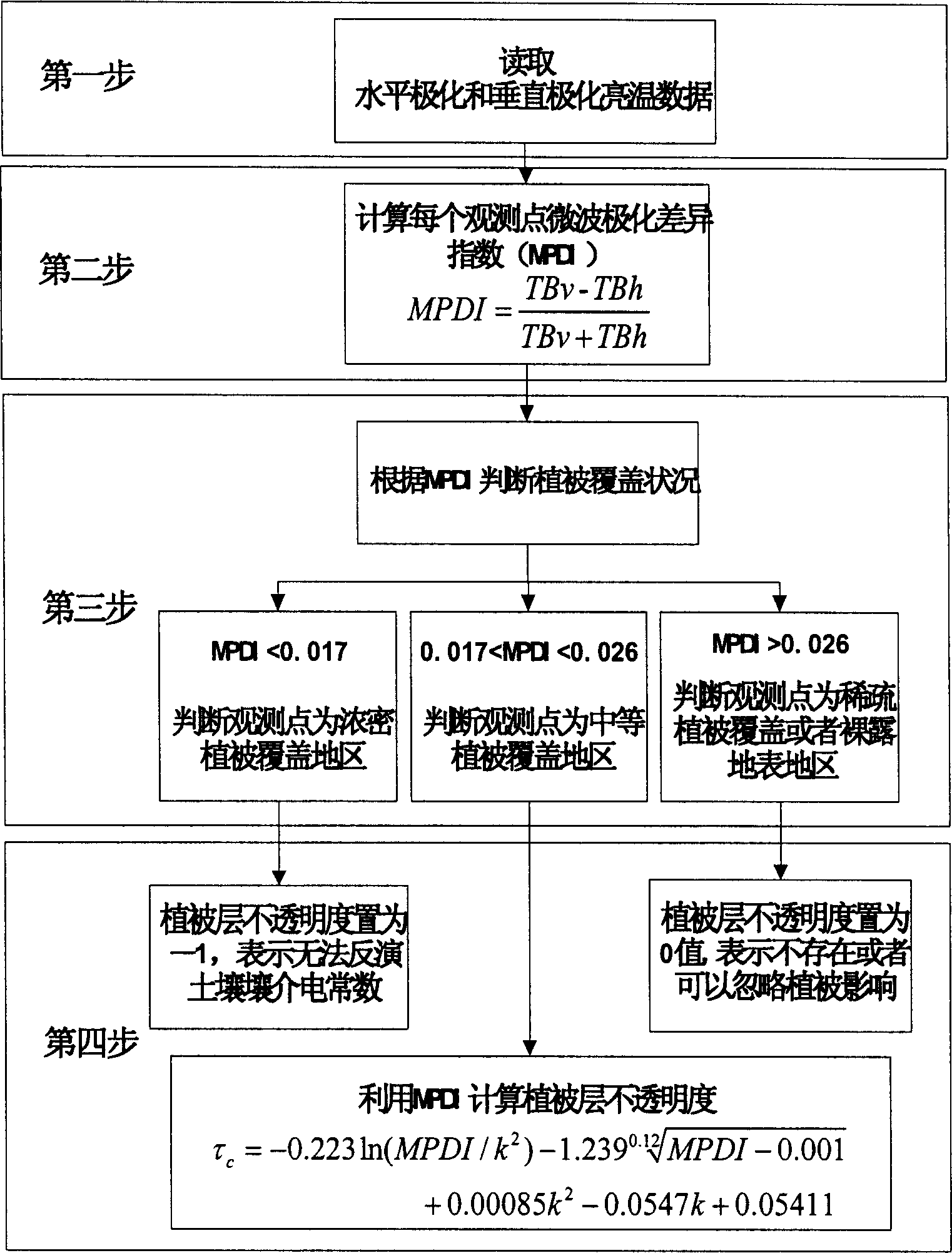
[0016] The second step is to establish a projection transformation index table according to the geographic coordinate data of the observation point, calculate the opacity parameter of the vegetation layer at the observation point, and invert the surface soil dielectric constant;

[0017] The third step is to obtain the soil water content according to the inversion calculation of the dielectric constant;

[0018] The fourth step is to map the soil water content distribution map and save it as a common image file format.

[0019] Step 1: Prepare the operating environment and radiometer data. ...


PUM


Abstract

The present invention relates to the application of microwave remote sensing technology, and is especially microwave radiometer method of monitoring soil moisture. The method includes the following steps: 1. preparing operation environment and radiometer data; 2. inverting to obtain field surface dielectric constant of the observed point and forming grids; 3. calculating the soil moisture based on the dielectric constant; and 4. mapping soil moisture distribution and saving as common graph format.

Description

technical field [0001] The invention is used in the application field of microwave remote sensing technology, in particular to a method for retrieving soil moisture by using microwave radiometer data. Background technique [0002] In the existing method of using microwave radiometer to invert the surface soil moisture, when calculating the opacity of the surface vegetation layer, auxiliary data about the classification of the surface vegetation type and the water content of the vegetation layer are needed. The calculation formula is: [0003] τ c =b*ω / cosθ [0004] where b is a parameter related to the vegetation canopy structure and frequency, ω is the water content of the vegetation layer, and θ is the observation angle. Both b and ω need to be obtained through auxiliary data. However, in practical applications, these auxiliary data are often difficult to obtain or unreliable, and even if this part of the data is obtained, the application is more complicated (eg figure...

Claims


Application Information

Patent Timeline
Patent Type & Authority Applications(China)
IPC IPC(8): G01N22/04
Inventor 李震王磊
Owner REMOTE SENSING APPLIED INST CHINESE ACAD OF SCI
Why Eureka
Try Eureka