System and method for a digital image sextant

a digital image and sextant technology, applied in the field of sextants and navigation, can solve the problems of difficult to accurately capture useful angular measurement like, the need for an alternative and independent positioning system to gps remains undiminished, and the difficulty of accurately manipulating the devi

Active Publication Date: 2020-04-14
BERTRAND WILLIAM
View PDF9 Cites 1 Cited by
  • Summary
  • Abstract
  • Description
  • Claims
  • Application Information

AI Technical Summary

Problems solved by technology

The need for an alternative and independent positioning system to GPS remains undiminished due to the vulnerability of GPS to external signal spoofing and other forms of signal disruption and denial (Pappalardi, et al., (2001).
It is difficult to accurately capture useful angular measurements like sextant altitudes with these devices because of several factors.
2) The measurement is often taken on a vehicle, such as a watercraft, aircraft, or the like, that is usually in motion including translation, roll, pitch, yaw and spin, making accurate manipulation of the device challenging.
Taking such a measurement is so challenging, that extensive training and experience is typically required to successfully use such devices to practical effect, and still wide variation exists in the ability of practitioners.
Conditions like weather may reveal the objects for too brief a time for the sextant user to manipulate the device and capture the required angle or angles.
Further, such devices require human operation, thus preventing practical autonomous celestial navigation.
While GPS is readily available it is known to be unreliable particularly in times and regions of conflict where combatants disrupt, alter, or provide false GPS signals.

Method used


Image

  • System and method for a digital image sextant
  • System and method for a digital image sextant
  • System and method for a digital image sextant

Examples


example 1

Jupiter Fla., South of Jupiter Inlet

I Digital Image Sextant (DIS)

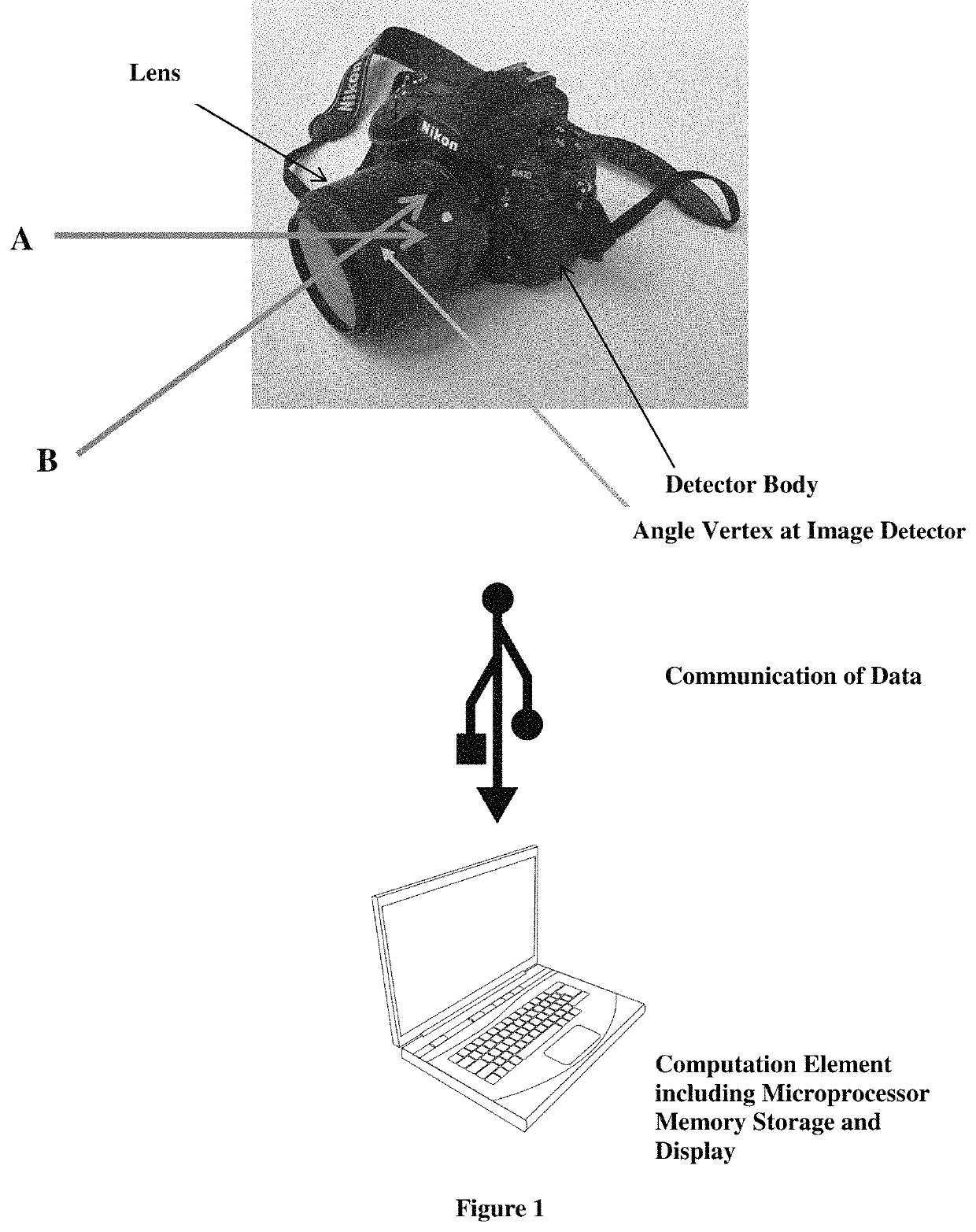
[0070]Referring to FIG. 1, illustrated in this exemplary embodiment is a system for measuring angular distances. The system comprises an imaging device which includes a lens, a digital image detector, a means of storage of captured digital images, a computational element, with digital memory storage, including non-transitory computer memory, a means to input data, and a display. The computational element further comprises computer software, or computer readable institutions to enable the system as disclosed herein. A means to communicate digital information, including images, between the image detector to the computations element is indicated. The exemplary embodiment in FIG. 1 is a system comprised of digital camera in communication with a personal computer containing software, via a USB portal. The computational element or computational hardware and software including computer readable instructions enable it to deter...

example 2

Lake Michigan

Experimental Conditions

The Digital Image Sextant (DIS)

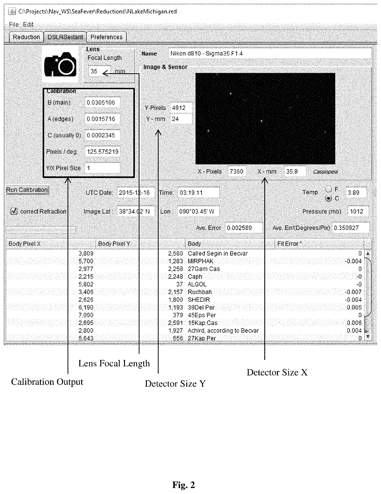
[0168]The celestial fixes presented in Example 2 were all made with the same DSLR (Digital Single Lens Reflex Camera) and lens: a Nikon D-810® camera and Sigma DG 067® (35 mm F1.4) lens.

[0169]The dimensions X, Y and pixels M, N of the CMOS detector are,[0170]X=35.9 mm & M=7360 pixels.[0171]Y=24.0 mm & N=4912 pixels

[0172]The field of view (FOV) is 54.3 degrees of arc calculated as follows:

[0173]FOV=2⁢⁢tan⁡(sizeX2*Focal⁢⁢Length)=2⁢⁢atan⁡(35.9⁢⁢mm2*35⁢⁢mm)=54.3⁢⁢degrees

Exposure

[0174]Exposure parameters are designed to accommodate measurements taken on moving platforms. All images were taken hand held.[0175]Exposer time: 1 / 125 sec[0176]ISO Speed: 12,800[0177]F-Number: variable

Procedure

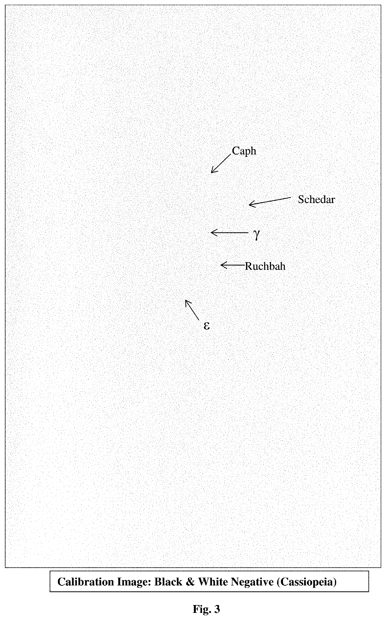
[0178]The Yale Bright Star Catalog (Hoffleit, et al., “The Bright star catalogue.” New Haven, Conn.: Yale University Observatory, c1991, 5th rev. ed., edited by Hoffleit, Dorrit; Jaschek, Carlos (1991)) was incorporated into the celestial n...


PUM


Abstract

Disclosed is a system of navigation that is not dependent on man-made satellites. Disclosed is a digital imaging system that may be calibrated using known angular distances and then used to determine unknown angular distances, including the angular distance of celestial bodies above the user's horizon. The digital imaging system may be used in conjunction with a celestial database to determine lines of position and establish a fix revealing the geographic location of the user. The system is expected to be most useful when employed on vessels at sea, including aircraft, and may also be useful on land. The invention offers an alternative to Global Positioning Systems, which are subject to inactivation by governments or traditional mechanical-optical sextants, which are time consuming and cumbersome to use.

Description

CROSS REFERENCE TO RELATED APPLICATIONS[0001]This application claims priority to provisional application 62 / 541,724 filed Aug. 6, 2017, and provisional application 62 / 541,667, filed Aug. 5, 2017, both of which are hereby incorporated by reference in their entirety.FIELD OF THE INVENTION[0002]The present invention relates to methods and apparatus to measure angular distances from digital images. One embodiment of the present invention is related to the field of sextants and navigation.BACKGROUND OF THE INVENTION[0003]The need for an alternative and independent positioning system to GPS remains undiminished due to the vulnerability of GPS to external signal spoofing and other forms of signal disruption and denial (Pappalardi, et al., (2001). Alternatives to GPS. In OCEANS, 2001. MTS / IEEE Conference and Exhibition (Vol. 3, pp. 1452-1459). IEEE). To this end, the U.S. Navy continues to teach and practice celestial navigation. Conventional celestial navigation instruments, such as sextan...

Claims


Application Information

Patent Timeline
Patent Type & Authority Patents(United States)
IPC IPC(8): G06T7/50H04N5/77H04N9/82G01C1/08G01C25/00G06T7/80G06T7/73G06T5/00G01C21/02H04N5/232H04N5/907G06F16/583
CPCG01C21/025G01C1/08H04N5/23216H04N5/77G06T5/006G06T7/74G06T7/50G06T7/80G01C25/00H04N9/8205H04N5/907G06F16/5838G06T2207/20092H04N23/62
Inventor BERTRAND, WILLIAM
Owner BERTRAND WILLIAM
Why Eureka
Try Eureka