
Wide area inverse differential GPS

a wide area and inverse differential technology, applied in wave based measurement systems, navigation instruments, instruments, etc., can solve the problem of impracticality of long averaging periods

Inactive Publication Date: 2002-06-13
AVAGO TECH INT SALES PTE LTD
View PDF0 Cites 34 Cited by
  • Summary
  • Abstract
  • Description
  • Claims
  • Application Information

AI Technical Summary

Benefits of technology

[0009] The GPS processing elements in the mobile devices include a highly parallel GPS correlator that is capable of searching and detecting signals over a wide range of unknown signal delays. The highly parallel nature of the GPS processing allows the system to use long averaging periods which are impractical for a conventional GPS receiver that searches for signals sequentially using a small number of correlators. The long averaging times are made possible by the parallel correlation that allow the system to locate objects in difficult signal environments, such as inside buildings, where conventional GPS cannot function.

Problems solved by technology

The highly parallel nature of the GPS processing allows the system to use long averaging periods which are impractical for a conventional GPS receiver that searches for signals sequentially using a small number of correlators.

Method used


Image

  • Wide area inverse differential GPS
  • Wide area inverse differential GPS
  • Wide area inverse differential GPS

Examples


second embodiment

[0036] Hardware implementation of the parallel GPS correlator, described a parallel GPS correlator used for detection and measurements of GPS signals at a mobile device.

OVERVIEW

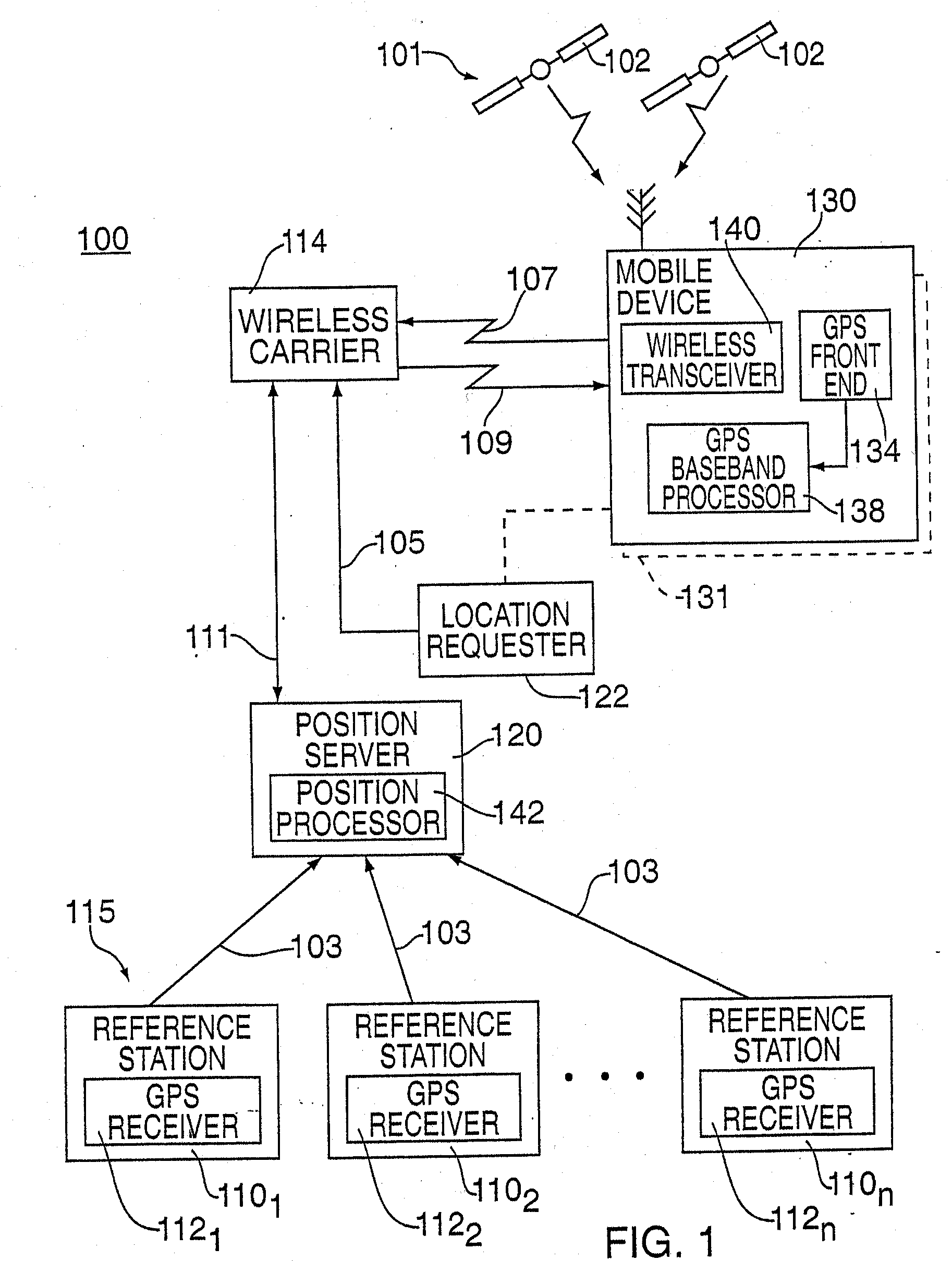
[0037] The invention provides a method and apparatus for locating a mobile device over a broad coverage area using a wireless communications link that may have large and unknown latency. The apparatus comprises at least one mobile device containing global positioning system (GPS) processing elements, a GPS reference network comprising a plurality of fixed site GPS receivers at known locations, a position server with software that executes GPS processing algorithms, a wireless communications link, and at least one location requester.

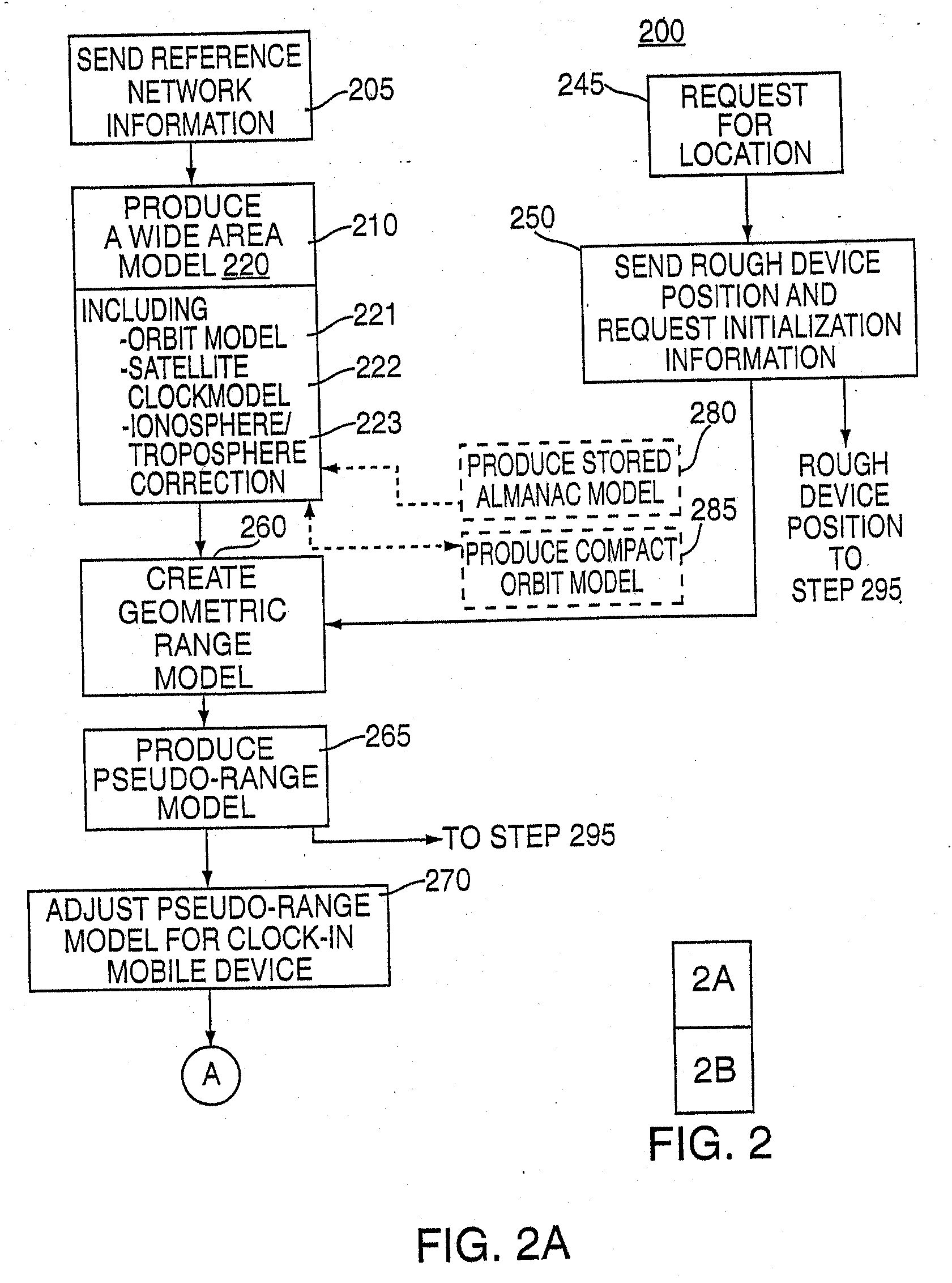
[0038] The method consists of using GPS measurements obtained at the fixed site GPS receivers to build a wide area model of the GPS constellation that includes real-time models for satellite orbits, satellite clocks, and ionosphere and troposphere delays. The wide area model is use...

first embodiment

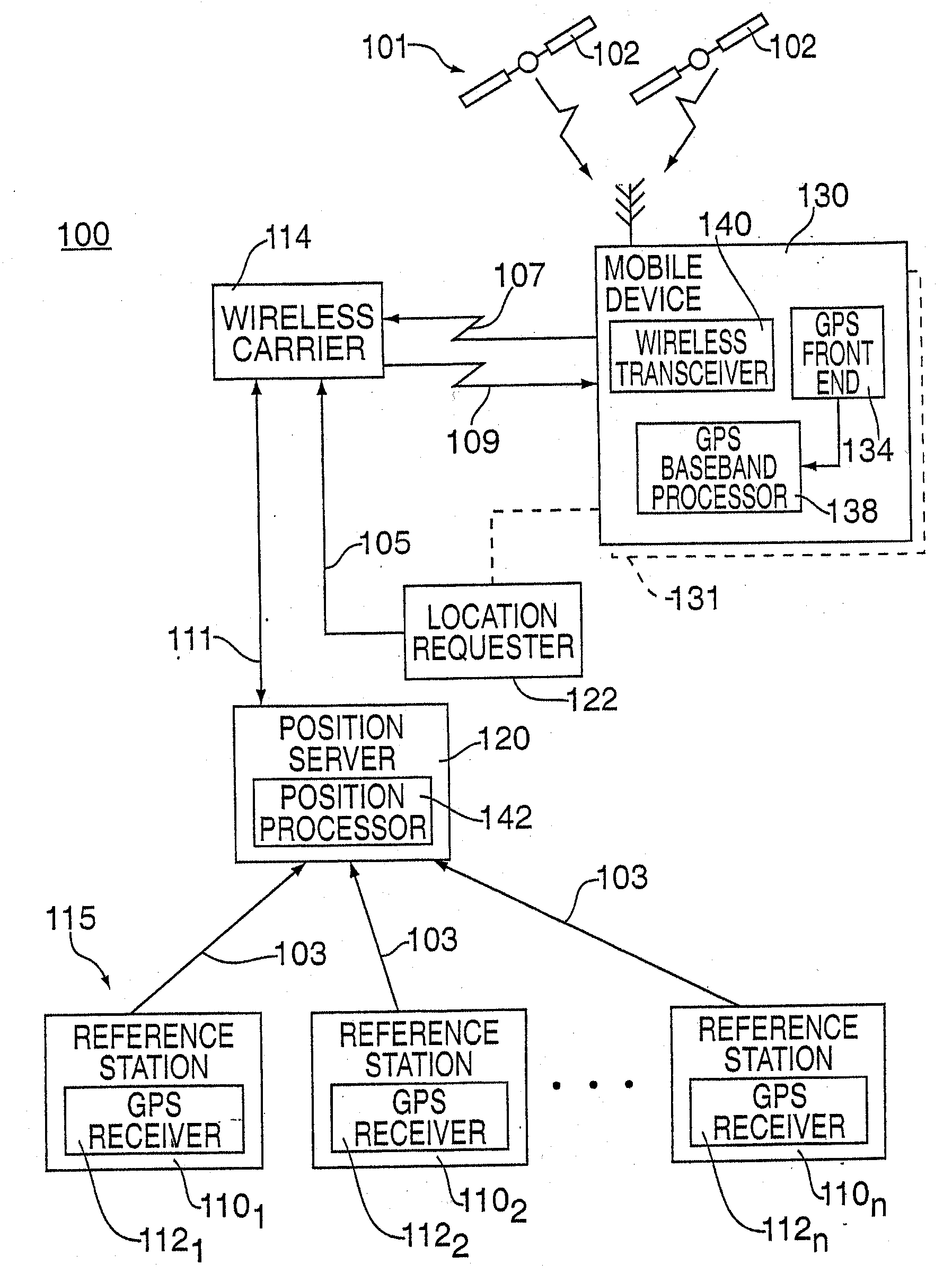
[0043] FIG. 1 depicts a block diagram of a personal and asset location system (PALS) 100. The PALS 100 uses a Global Positioning System (GPS) 101 (or other similar satellite position location system) having a plurality of satellites 102 orbiting the earth. PALS 100 comprises a reference station network 115 comprising a plurality of geographically dispersed reference stations where each reference station comprises a fixed site GPS receivers 110.sub.1 through 110.sub.n (collectively fixed site GPS receiver 110), a position server with software that executes GPS processing algorithms 120 and a plurality of mobile devices 130. The mobile devices 130 are coupled to or otherwise associated with an object that is to be located, e.g., mobile object 131 including personal assets, equipment, persons and the like. The mobile devices 130 communicate with the position server 120 via a wireless carrier 114. Each reference station 110 further comprises a conventional GPS receiver 112.sub.1 through...


PUM


Abstract

<heading lvl="0">Abstract of Disclosure< / heading> A method and apparatus for locatiredetermining the sets of millisecond integers until a set of millisecond integers solves for the position of the GPS device.ng mobile device over a broad coverage area using a wireless communications link that may have large and unknown latency. The apparatus comprises at least one mobile device, a reference network, a position server, a wireless carrier, and a location requester. The mobile device is in communication with the wireless carrier and receives global positioning system (GPS) signals from a plurality of satellites in the GPS satellite constellation. The reference network is coupled to the position server and provides GPS data. The mobile receiver receives GPS signals, performs rudimentary signal processing and transmits the processed signals to the wireless carrier. The wireless carrier passes the signals on to the position server. The position server processes the mobile receiver's GPS data and the reference network ephemeris data to identify the location of the mobile receiver. The location is sent to the location requester.

Description

Cross Reference to Related Applications[0001] This application is a continuation of pending U.S. patent application serial number 09 / 553,930, filed April 21, 2000, entitled "METHOD AND APPARATUS FOR LOCATING AND PROVIDING SERVICES TO MOBILE DEVICES", which claims benefit of U.S. provisional patent application serial number 60 / 130,882, filed April 23, 1999, both of which are hereby incorporated by reference in their entirety.Background of Invention1. Field of Invention[0002] The present invention relates to mobile wireless devices as used in personal and asset location systems. In particular, the present invention relates to a method and apparatus for utilizing the Global Position System (GPS) to locate objects over a large geographic region and to provide information or services related to a real time position of the object.2. Description of the Background Art[0003] With the advent of the Global Positioning System (GPS), there is growing demand for mobile devices that can locate and...

Claims


Application Information

Patent Timeline
IPC IPC(8): G01S19/27G01S1/00G01S5/00G01S5/14G01S19/23G01S19/25
CPCG01S5/0036G01S19/05G01S19/06G01S19/09G01S2205/002G01S19/235G01S19/258G01S19/27G01S19/30G01S19/17
Inventor FUCHS , DONALD L.ABRAHAM , CHARLESVAN DIGGELEN , FRANK
Owner AVAGO TECH INT SALES PTE LTD
Learn More