Pseudo-noise correlator for GPS spread-spectrum receiver

a spread-spectrum receiver and pseudo-noise technology, applied in multi-frequency code systems, distance measurement, instruments, etc., can solve the problems of limited acceptance, difficult maintenance of continuous reception from four gps satellites, and increased complexity and cost of such combined systems

Inactive Publication Date: 2002-10-10
CSR TECH INC
View PDF0 Cites 22 Cited by
  • Summary
  • Abstract
  • Description
  • Claims
  • Application Information

AI Technical Summary

Problems solved by technology

Because continuous reception from four GPS satellites is often difficult to maintain in a car navigation environment, and known clock and altitude hold techniques can only permit operation with at least two satellites, known conventional car navigation systems have typically augmented the GPS position information with information from external sensors to provide dead reckoning information.
However, the resultant increased complexity and costs for such combined systems have limited their acceptance.
GPS systems, as well as many other radio frequency (RF) communication systems utilizing frequencies high enough to be considered line of sight systems in which there must be a substantially direct line of sight between the transmitter(s) and receivers(s) for optimum operation, often suffer from multipath effects in which the receiver(s) must process signals received over a multiplicity of different paths.
The multiplicity of signals being received results from additional, typically unwanted, signals paths including one or more reflections.
Multipath signals present a problem in systems, such as GPS systems, in which the time of arrival of the signal is to be measured or used because the time of arrival of the multipath signals depends on the length of the path(s) taken.
The straightforward processing of all signals, including multipath or reflected signals, often degrades the processing performed by the receiver.
In the simple broadcast TV transmission system described above, the processing of unmodified multipath signals by the receiver results in the commonly experienced degradation called "ghosting" in which multiple signals are displayed offset in the TV image.
In other types of systems, such as the GPS systems using PRN encoded spread spectrum signals, certain conventional techniques are difficult or impossible to use.
This makes a highly directional antenna system almost completely unusable.
Multipath processing techniques currently used for complex receivers, such as GPS receivers, are often quite complex and subject to inaccuracies.
This technique of comparing processed and estimated correlation power, is complex and may be subject to error in that the partially processed signals relied on are themselves subject to degradation from many effects in addition to multipath effects including receiver limitations, which may reduce the accuracy or effectiveness of the multipath processing techniques.
If, as in most common cases, the multipath signal(s) are weaker than the direct path signals, the interference between such signals as received results in a predictable distortion of the correlation function.
When the correlation function of the composite is distorted to be wider than the correlation function expected for a direct path only signal, the distortion results in a lag error in which the prompt correlation lags the actual direct path signal received.
Similarly, when the correlation function of the composite is narrower than expected, the distortion results in a lead error in which the prompt correlation leads the time of arrival of the direct path signal.
Even with 4 satellites in view, the geometry of the visible satellites may make it difficult to determine position by measurement of GPS signals.
Further, during terrestrial navigation, it is not uncommon for satellites to be temporarily obscured from view during navigation by, for example, being blocked by buildings and other obstructions.
However, unless the obscuration of the satellite signals is very brief, the accuracy of prediction of such techniques is not enough to maintain synchronization exception for a very brief period of obscuration.
Such registers would be expensive in cost and gate count and quite cumbersome.
Although multiplexing factors can be used successfully even if the product is not exactly equal to an even integer multiple, data loss or unnecessary complexity and costs may result.

Method used


Image

  • Pseudo-noise correlator for GPS spread-spectrum receiver
  • Pseudo-noise correlator for GPS spread-spectrum receiver
  • Pseudo-noise correlator for GPS spread-spectrum receiver

Examples


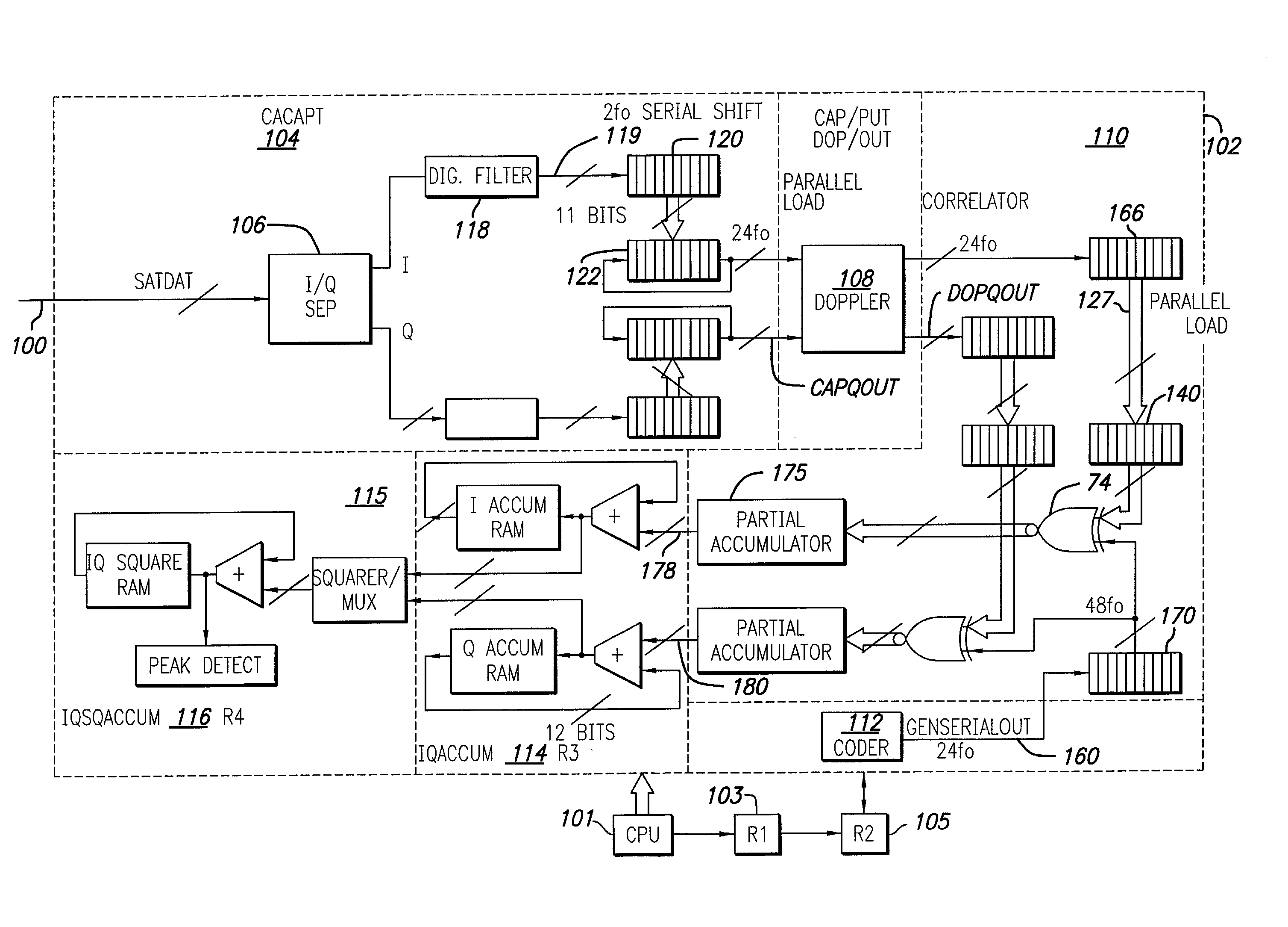
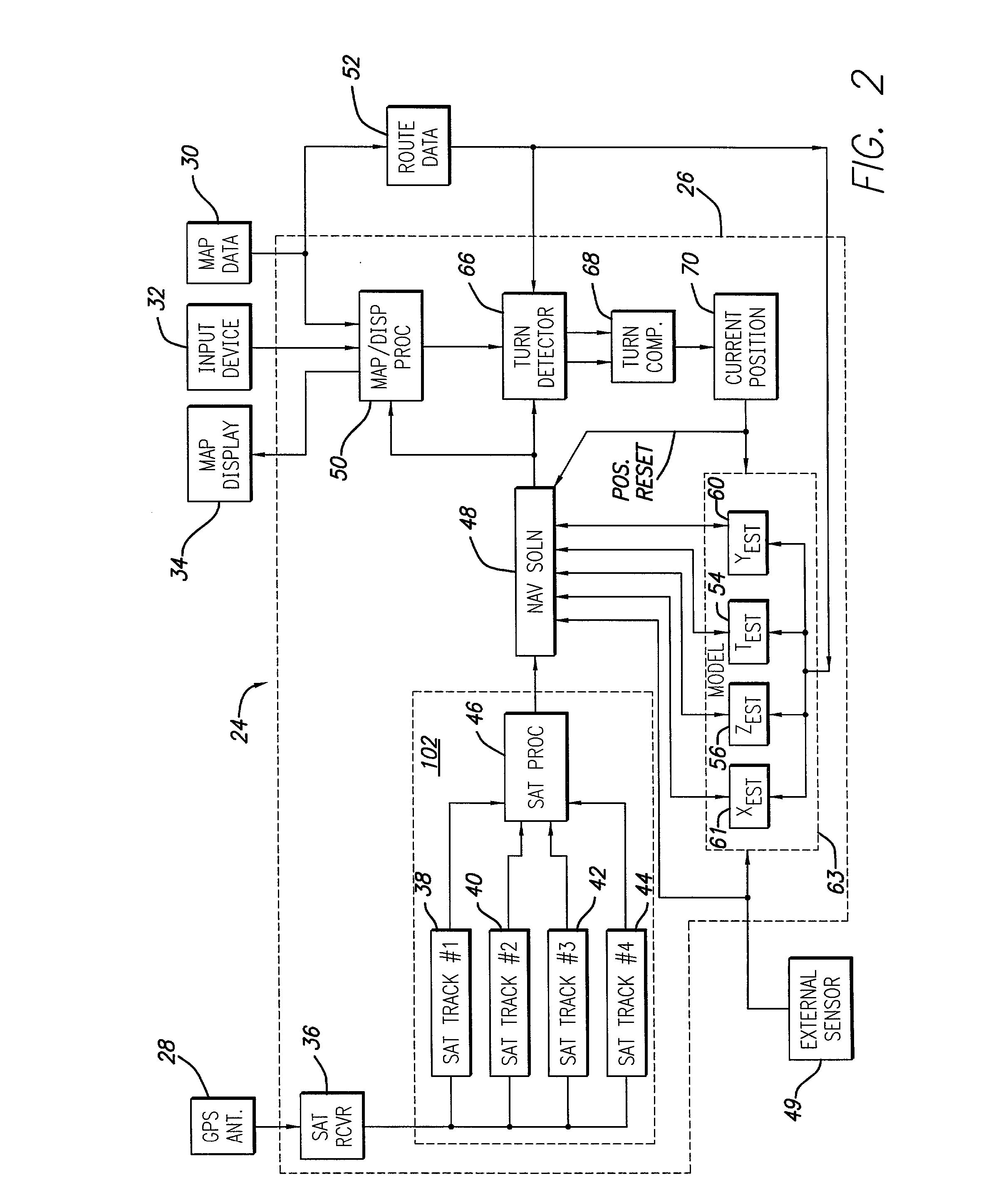
Embodiment Construction

GRF1 Signal Description Pin No. Symbol Type Description 1, 2 IF, {overscore (IF)} Inputs Differential IF inputs: balanced inputs to the IF stage; a filter should be placed between these inputs and the mixer outputs. DC bias to the positive supply must be applied to these pins. 3, 4 {overscore (MIX)}, MIX Outputs Differential IF Outputs; balanced outputs of the LNA / Mixer stage, a filter should be placed between these outputs and the IF inputs. DO bias to the positive supply must be applied to these pins. 5 VEE (LNA) Input LNA / Mixer ground pin. 6, 7 {overscore (RF)}, RF Inputs Differential LNA inputs. For best performance a balun should be used. Decouping should be to ground. 8 VCCLNA Input Postive supply input for LNA / Mixer block. Decoupling to ground via 0.01 .mu.F or larger capacitors should be provided. 9 VCCVCO Input Postive supply input for VCO block. Decoupling to ground via 0.01 .mu.F or larger capacitors should be provided. 10 VEEVCO Input VCO ground pin. 11 VEECHP Input Char...


PUM


Abstract

A terrestrial C / A code GPS receiver system digitally samples, filters and stores a segment of 11 half chips of the received composite as a binary number and multiplexes this number for parallel correlation with each of a series of multibit code replicas for the satellites to be tracked. Each of the time delay specific correlation products are accumulated in a cell of a memory matrix so that at least twenty two delays for each satellite may be evaluated each code period providing fast reacquisition, even within a city intersection, as well as correction of multipath tracking and multipath interference. All cells of the memory matrix may be used for an acquisition of a single satellite in about 4 ms. Two satellite tracking, in addition to altitude hold, uses cross track hold alternating with clock hold to update the cross track estimate. Single satellite tracking uses cross track and clock hold together. Navigation data is updated with detected changes in motion including turns.

Description

[0001] This application is a continuation of Serial No. 09 / 655,633, filed Sep. 5, 2000 which is a divisional of Serial No. 08 / 846,067, filed Apr. 25, 1997, which is a continuation-in-part of Serial Nos. 08 / 637,457, abandoned; 08 / 638,021, now U.S. Pat. Nos. 5,901,171; 08 / 637,537, now U.S. Pat. Nos. 6,041,280; and 08 / 638,882, now U.S. Pat. No. 5,897,605, all filed Apr. 25, 1996 and claims the priority of provisional patent application 60 / 042,868 filed Mar. 28, 1997.[0002] 1. Field of the Invention[0003] This invention relates in general to spread spectrum receivers and in particular to GPS navigation systems such as those used in terrestrial navigation for cars, trucks and other land vehicles.[0004] 2. Description of the Related Art[0005] Car navigation is conventionally performed using highway and street maps aided, to some degree, by distance measurements from external sensors such as odometers. Improvements over the last 10 years in Global Positioning System, or GPS, satellite navi...

Claims


Application Information

Patent Timeline
Patent Type & Authority Applications(United States)
IPC IPC(8): G01C21/26G01S19/30G01C22/00G01S1/00G01S5/14G01S19/34G01S19/47G01S19/50H04B1/707H04B1/7085H04B1/709H04B1/7095H04B1/7115H04B7/216
CPCG01C21/26H04B2201/70715G01S19/11G01S19/22G01S19/235G01S19/29G01S19/30G01S19/34G01S19/37G01S19/47G01S19/49G01S19/50H04B1/707H04B1/7085H04B1/709H04B1/7095H04B1/7115H04B7/216H04B2001/70706G01C22/00H04L27/30
Inventor KOHLI, SANJAICHEN, STEVENCAHN, CHARLES R.CHANSARKAR, MANGESHTURETSKY, GREG
Owner CSR TECH INC
Why Eureka
Try Eureka