
Satellite-based positioning system improvement

a satellite-based positioning system and satellite technology, applied in the field of receivers, can solve the problems of requiring equally as much energy for subsequent fixes, affecting the signal quality of the receiver, and the receiver's entire signal quality, etc., and achieve the effect of improving the signal-to-noise ratio

Inactive Publication Date: 2008-07-24
U-BLOX
View PDF36 Cites 8 Cited by
  • Summary
  • Abstract
  • Description
  • Claims
  • Application Information

AI Technical Summary

Benefits of technology

[0013]In many assisted GPS applications rapid acquisition of satellite signals is a key requirement. Acquisition is delayed because of drift of the reference oscillator in the receiving unit. The relative velocity along the line of sight from the receiver to the satellite induces a Doppler shift in the frequency of received signal. The Doppler shift contains useful information on the velocity of the receiver antenna, but the presence of the Doppler shift necessitates a frequency search that increases the time for acquisition. Reference oscillator drift is a major contributor to lengthening acquisition time as it causes the “Doppler” frequency search to be increased to allow for reference oscillator drift. By utilizing the precise signal framing of a digital communications link, the invention calibrates a local oscillator and thus reduce the effect of drift. This is accomplished by counting local oscillator cycles and fractions thereof over a period precisely determined by a number of signal framing intervals. Once the calibration offset is determined it is used as a correction by the GPS receiver firmware when performing acquisition searches or it can be used to correct the oscillator frequency so as to minimize the offset.Cancellation of Cross Correlation
[0014]Another aspect of the invention is the reduction of cross correlations between weak and strong signals experienced at correlator outputs. These cross-correlations are inherent limitations of the GPS C / A Code structure. The cross correlations between codes at certain code and Doppler offsets are only 20 dB between the peak of the autocorrelation main lobe. At the correlator output these cross-correlations are indistinguishable from correlations with the locally generated replica of the weak signal being sought. Reducing the level of cross-correlations caused by a strong signal will reduce its jamming effect on weaker signals. In this way the usable dynamic range is increased to permit weak signals to be acquired, tracked and used in the presence of strong ones. At least 3 satellites are needed to make a 2D fix and 4 satellites are require to make a 3D fix. Furthermore, more than the minimum number may be required to obtain a low enough Dilution Of Precision to permit an accurate fix to be made. Hence the ability to use more of the signals present is an advantage. In urban canyons this advantage will be distinct in that there are often only one or two strong signals present and these jam all of the weaker ones. The biggest problem with the concept of canceling the strong signals is that the signals are represented with very low precision at the input to a correlator and, hence, any scaling of the signal can only be extremely crudely performed. This threatens the viability of the concept. The present invention provides allows the scaling to be performed at a point where the signal is represented by 10 bit samples and scaling is much more feasible.Doppler Location Scheme
[0016]A still further aspect of the invention concerns the limitations on sensitivity caused by limitation in performing Fourier transforms. The transform involves accumulating values in frequency bins. Previous algorithms are limited in sensitivity because the reduction of binwidth is offset by squaring losses. This causes growth of the FFT (fast Fourier transform) size to impractical lengths. To overcome this problem a spectral averaging algorithm is employed for integration periods beyond 160 ms (FFT length of 128). To avoid excessive memory usage for storing FFT arrays, the invention operates in the fashion of a moving average by filtering the squared magnitudes of the FFT bins in the same fashion as for the autoconvolutions when acquiring.Calculation of Almanac Aiding from Table of Orbit Coefficients
[0017]A still further aspect of the invention reduces the traffic from the receiver to the aiding source. In particular, an alternative is provided to having the receiver acquire its own almanac data and requesting augmentation coefficients for a specific Issue Of Almanac as aiding information. Instead the invention hardcodes orbital coefficients into a lookup table and the aiding information is provided as broadcasts at regular intervals.Absolute Time Determination
[0019]A still further aspect of the invention is a modified search engine. Modern GPS receivers often incorporate massively parallel correlation hardware to speed the acquisition process by concurrently searching across a broad range of codephases and / or Doppler frequencies. Such hardware are sometimes referred to as search engines. The signal processing algorithms utilized in the invention can be incorporated into a modified search engine to achieve even faster searching by reducing the length of integration period required.

Problems solved by technology

Moreover, subsequent fixes require equally as much energy as the satellites must be acquired from scratch again.
Firstly, the power hungry search engine can be turned off.
Secondly, the entire receiver can be duty cycled over quite long periods to achieve considerable savings.

Method used


Image

  • Satellite-based positioning system improvement
  • Satellite-based positioning system improvement
  • Satellite-based positioning system improvement

Examples


Embodiment Construction

[0032]This invention relates to refinements and extensions to a commonly owned invention disclosed in U.S. Pat. No. 5,459,473. Accordingly, the foregoing U.S. patent is hereby incorporated by reference.

Aiding Source / Receiver Interaction

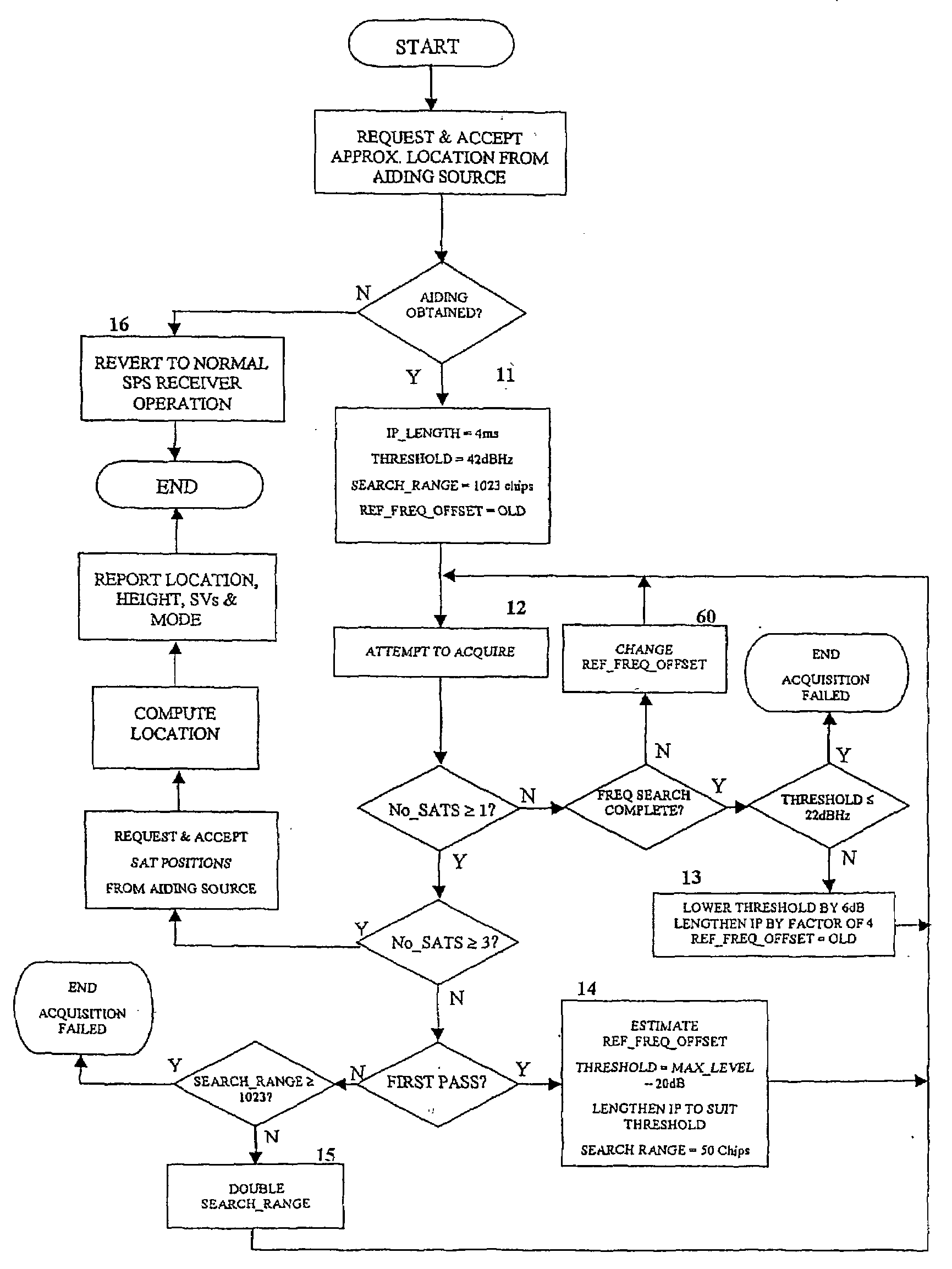
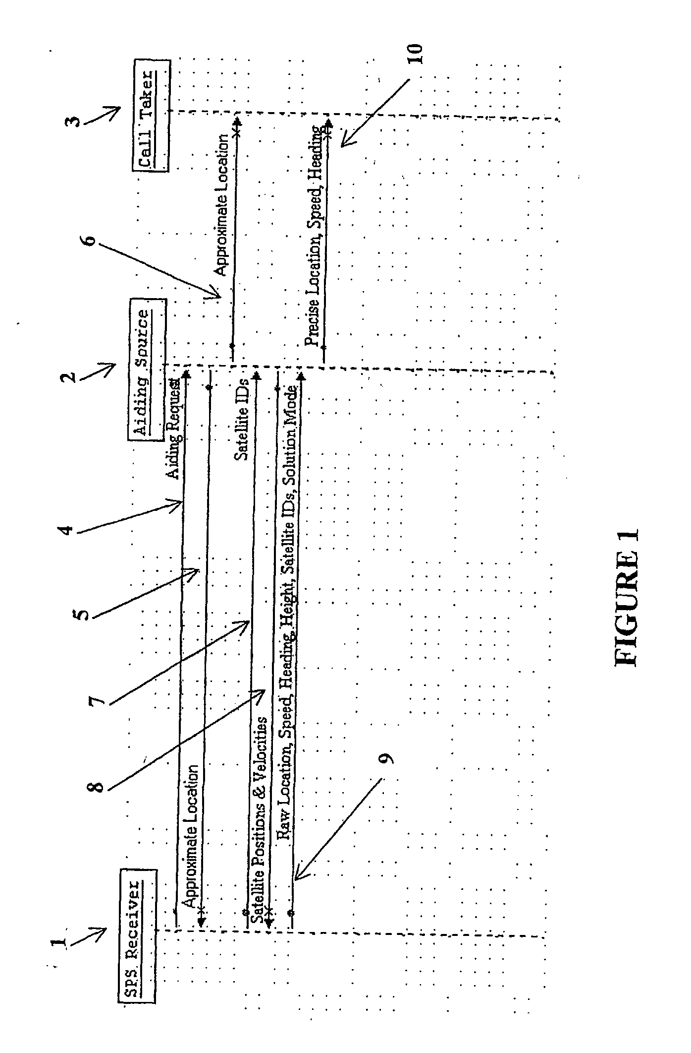
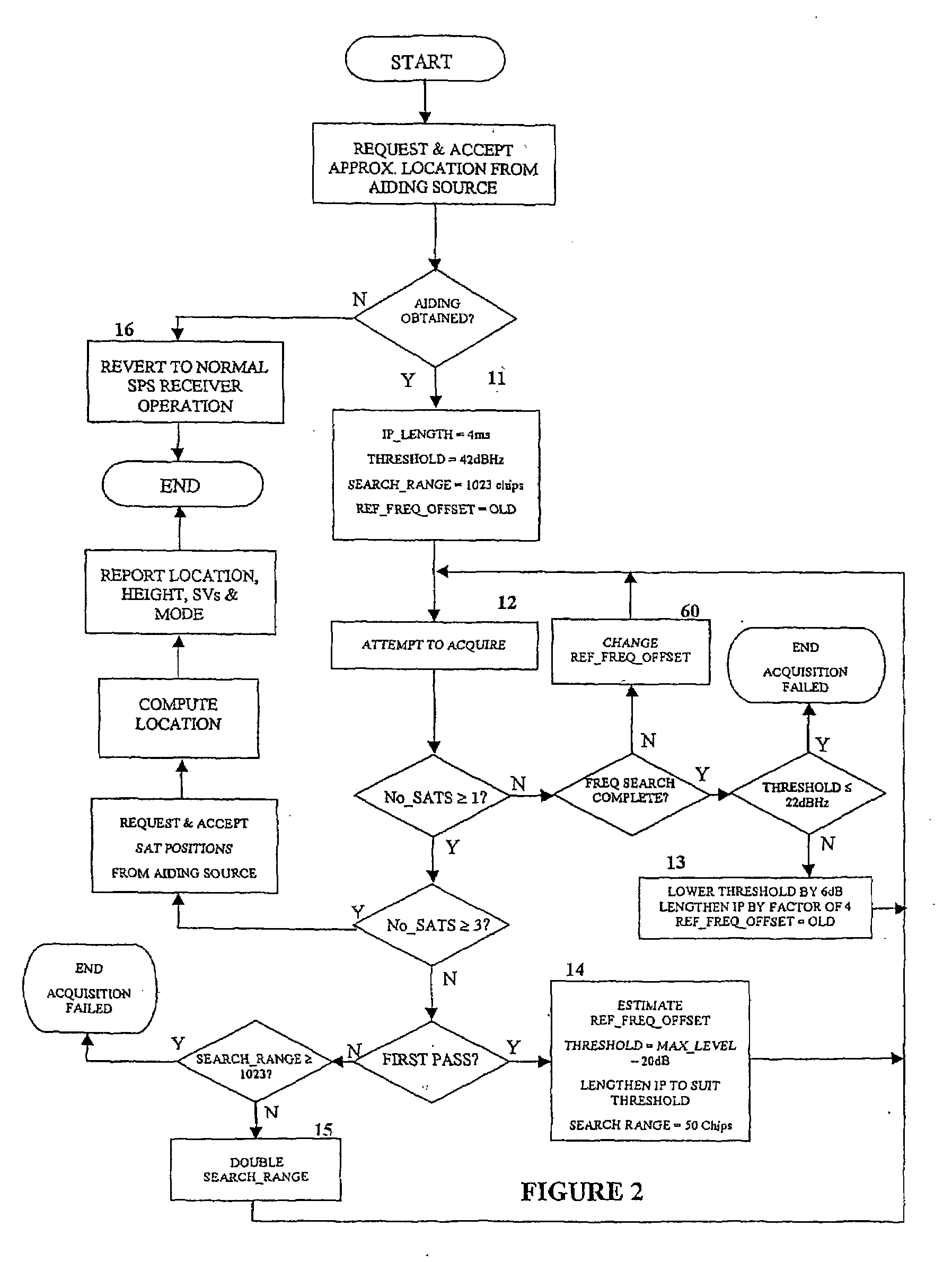
[0033]As previously described, the aiding data used in accordance with the present invention may be limited to information that includes an approximate location for an SPS receiver and the positions and velocities of a specific set of satellites. This information is determined and provided through a request / response sequence. A model of one embodiment of such an exchange in accordance with the present invention is depicted in FIG. 1.

[0034]A typical exchange might involve an SPS Receiver 1, an Aiding Source 2 and a Call Taker 3. For instance, the SPS Receiver 1 might be a GPS receiver embedded in or co-located with a wireless telephone or other handset. The Aiding Source 2 may be located at a call center or cell site or elsewhere in the wireless networ...


PUM


Abstract

A method, device and system for determining a receiver location using weak signal satellite transmissions. The invention involves a sequence of exchanges between an aiding source and a receiver that serve to provide aiding information to the receiver so that the receiver's location may be determined in the presence of weak satellite transmissions. With the aiding information, the novel receiver detects, acquires and tracks weak satellite signals and computes position solutions from calculated pseudo ranges despite the inability to extract time synchronization date f, ′n the weak satellite signals. The invention includes as features, methods and apparatus for the calibration of a local oscillator, the cancellation of cross correlations, a Doppler location scheme, an ensemble averaging scheme, the calculation of almanac aiding from a table of orbit coefficients, absolute time determination, and a modified search engine.

Description

[0001]This application claims the priority filing date of U.S. Provisional Application Ser. No. 60 / 416,367 filed on Oct. 4, 2002.FIELD OF THE INVENTION[0002]This invention relates to the design of receivers employed in satellite-based positioning systems (SPS) such as the US Navstar Global Positioning System (GPS), the Russian Global Navigation Satellite System (GLONASS) and the European Galileo system. More specifically, the invention relates to methods, devices and systems for determining a receiver location using weak signal satellite transmissions.BACKGROUND OF THE INVENTION[0003]Satellite based positioning systems operate by utilizing constellations of satellites which transmit to earth continuous direct sequence spread spectrum signals. Receivers within receiving range of these satellites intercept these signals which carry data (navigation messages) modulated onto a spread spectrum carrier. This data provides the precise time of transmission at certain instants in the signal ...

Claims


Application Information

Patent Timeline
Patent Type & Authority Applications(United States)
IPC IPC(8): G01S5/14G01S19/25G01S1/00G01S5/10G01S19/05G01S19/06G01S19/23G01S19/24G01S19/26G01S19/27G01S19/42H04B1/707
CPCG01S5/10G01S19/05G01S19/06G01S19/23H04B2201/70715G01S19/25G01S19/27G01S19/42G01S19/24G01S19/13G01S11/10
Inventor BRYANT, RODERICK C.DEMPSTER, ANDREW G.DOUGAN, STANLEY L.HOBBS, TREVORGLENNON, EAMONN P.
Owner U-BLOX
Learn More