Map generation system and map generation method by using GPS tracks

a map generation system and map technology, applied in traffic control systems, navigation instruments, instruments, etc., can solve the problems of complicated data processing, limited application range of the system, and current digital road maps that hardly meet the requirements of driving safety applications in terms of accuracy and information content, and achieve high-quality road maps. , the effect of low cos

Inactive Publication Date: 2008-10-23
HITACHI LTD
View PDF9 Cites 148 Cited by
  • Summary
  • Abstract
  • Description
  • Claims
  • Application Information

AI Technical Summary

Benefits of technology

[0014]According to an aspect of this invention, a ...

Problems solved by technology

However, current digital road maps hardly satisfy the requirements of a driving safety application in terms of accuracy and information content.
However, the application range of the system is limited because of problems such as the limited applicability of the system only to an extremely small range of survey, a long cycle required to collect data, complicated data processing after the survey, and a high cost for system maintenance.
However, efficient extraction of necessary information from complicated data suffers great technical difficulties.
Moreover, the generation of a highly accurate road map based on the conventional survey data requires resources and time.
However, since the GPS signal is a radio wave coming from a GPS satellite, the GPS signal is unavailable in some cases.
In the urban areas, in particular, positioning using the GPS cannot be used at a locatio...

Method used


Image

  • Map generation system and map generation method by using GPS tracks
  • Map generation system and map generation method by using GPS tracks
  • Map generation system and map generation method by using GPS tracks

Examples


Embodiment Construction

[0037]An embodiment of this invention will now be described referring to the accompanying drawings.

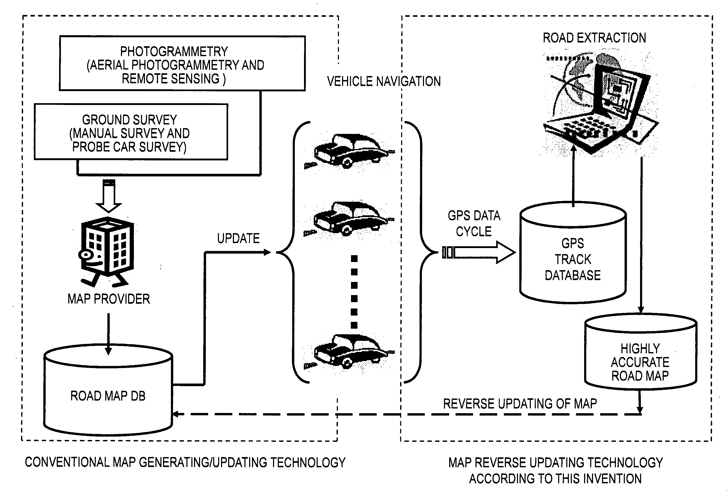
[0038]FIG. 1 illustrates a general outline of the embodiment of this invention. A basic concept of this invention will be described referring to FIG. 1.

[0039]The left part of FIG. 1 illustrates a conventional method of generating a road map as described above. Basic data used for the road map is obtained by, for example, air survey (photogrammetry and / or remote sensing) and a geographic survey (manual measurement and / or probe car survey) for each surveyed sector. Thereafter, a provider for providing the map (map-maker) uses the obtained basic data to manually or semi-automatically produce a road map. The map-making requires a high cost because a map-making process is extremely laborious and time-consuming as described above.

[0040]Map update for replacing old map data with new one has two levels of meaning. One corresponds to an update process between a map provider and a map databa...


PUM


Abstract

A map generation system comprising: a mobile device for acquiring location data of a vehicle and a status of the vehicle at a time of acquisition of the location; and a server for processing the acquired location data of the vehicle. The server comprises an input interface, a first storage unit, a processor and a second storage unit. The server includes a management unit for collecting a plurality of pieces of the track data obtained by a motion of the vehicle, an extraction unit for extracting feature points of the plurality of pieces of the track data on a road from which the plurality of pieces of the track data are collected to calculate a Spline curve satisfying the extracted feature points, and an update unit for adding the calculated Spline curve as a lane central line to the digital road map to update map data.

Description

CLAIM OF PRIORITY[0001]The present application claims priority from Japanese patent application JP 2007-108419 filed on Apr. 17, 2007, the content of which is hereby incorporated by reference into this application.BACKGROUND OF THE INVENTION[0002]This invention relates to a method of generating a digital road map, in particular, a technology of mapping a lane central line onto a road map by utilizing a driving trajectory of a vehicle.[0003]The integration of a digital road map and a precise positioning system is extremely significant for an advanced driving safety application which draws increasing attention as, for example, a next-generation vehicle navigation system. However, current digital road maps hardly satisfy the requirements of a driving safety application in terms of accuracy and information content. Therefore, there are increasing needs of mapping roads onto a map at high accuracy and in a detailed manner.[0004]Conventional road mapping technologies are based on data mea...

Claims


Application Information

Patent Timeline
IPC IPC(8): G06F19/00G01S5/00G01C21/26G08G1/0969G09B29/00G09B29/10
CPCG01C21/32G01C21/3837G01C21/3819
Inventor GUO, TAOKOGA, MASASHI
Owner HITACHI LTD
Why Eureka
Try Eureka