Satellite image fusion method and system

a fusion method and satellite image technology, applied in image enhancement, scene recognition, instruments, etc., can solve the problems of reducing spatial resolution, reducing the efficiency of fusion, so as to reduce the pixel value difference, enhance the fusion effect, and minimize the distortion of color information

Inactive Publication Date: 2009-09-10
KOREA AEROSPACE RES INST
View PDF10 Cites 38 Cited by
  • Summary
  • Abstract
  • Description
  • Claims
  • Application Information

AI Technical Summary

Benefits of technology

[0012]An aspect of the present invention is to address at least the above mentioned problems and/or disadvantages and to provide at least the advantages described below. Accordingly, an aspect of the present invent...

Problems solved by technology

By contrast, a multispectral image which collects data by segmenting wavelength range from the visible light band to the infrared ray and thermal ray bands per unit wavelength range, disadvantageously degrades the spatial resolution.
However, the IHS fusion method distorts color information of the multispectral image in fusing process because of a pixel va...

Method used


Image

  • Satellite image fusion method and system
  • Satellite image fusion method and system
  • Satellite image fusion method and system

Examples


Embodiment Construction

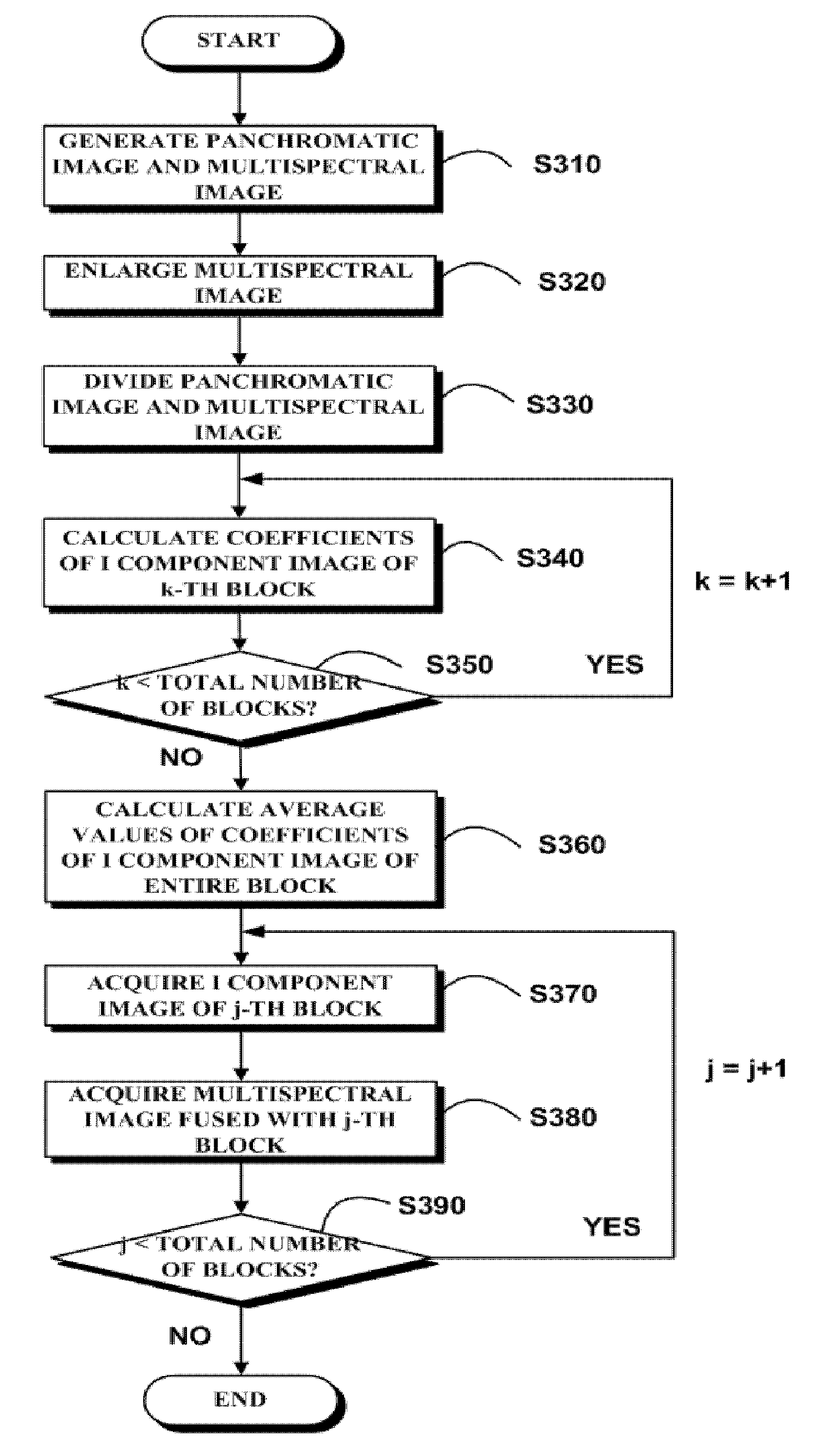
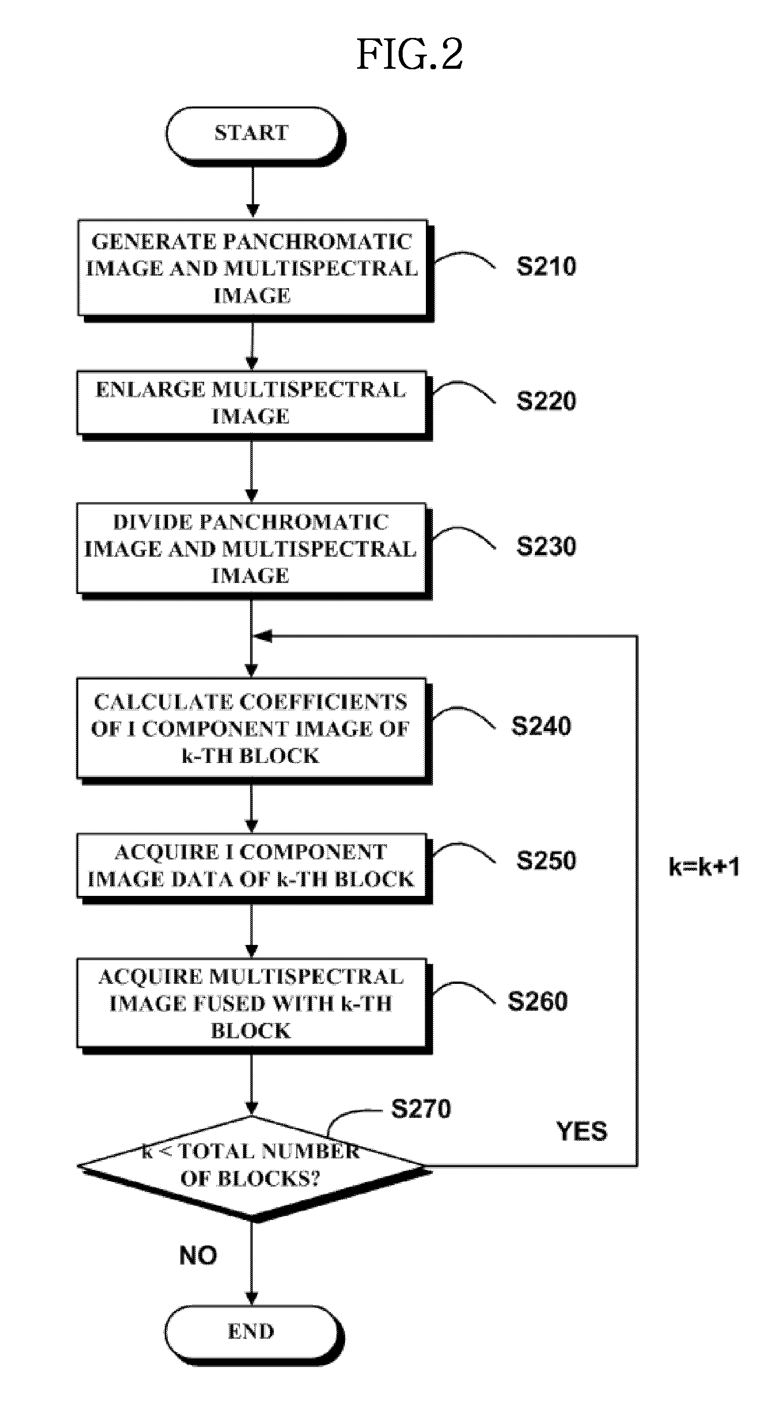
[0029]The following description with reference to the accompanying drawings is provided to assist in a comprehensive understanding of exemplary embodiments of the present invention as defined by the claims and their equivalents. It includes various specific details to assist in that understanding but these are to be regarded as merely exemplary. Accordingly, those of ordinary skill in the art will recognize that various changes and modifications of the embodiments described herein can be made without departing from the scope and spirit of the invention. Also, descriptions of well-known functions and constructions are omitted for clarity and conciseness.

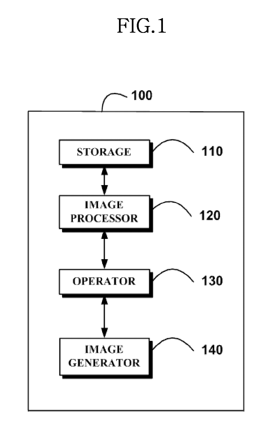
[0030]By referring to FIG. 1, a satellite image fusion system is illustrated according to an exemplary embodiment of the present invention.

[0031]FIG. 1 is a simplified diagram of the satellite image fusion system according to an exemplary embodiment of the present invention.

[0032]The satellite image fusion system 100 of FIG. 1 include...


PUM


Abstract

Satellite image fusion method and system are provided. The satellite image fusion method includes matching sizes of a panchromatic image and a multispectral image captured from a satellite image; dividing the panchromatic image and the multispectral image into a plurality of blocks; calculating coefficients to acquire Intensity (I) component image data using pixel values of each block of the multispectral image; and generating fused multispectral image data by applying the acquired I component image data to a fusion algorithm. In the multispectral image fusion, the distortion of the color information can be minimized and the multispectral image data of the high resolution can be attained. In addition, the present invention is applicable to not only the IKONOS images but also other satellite images, and the present image fusion can be carried out fast.

Description

CROSS-REFERENCE TO RELATED APPLICATIONS[0001]This application claims the benefit under 35 U.S.C. §119(a) to a Korean patent application filed in the Korean Intellectual Property Office on Mar. 7, 2008 and assigned Serial No. 10-2008-0021541, the entire disclosure of which is hereby incorporated by reference.BACKGROUND OF THE INVENTION[0002]1. Field of the Invention[0003]The present invention relates generally to satellite image fusion method and system. More particularly, the present invention relates to the satellite image fusion method and system for fusing panchromatic image data of a high resolution and multispectral image data of a low resolution using an IHS fusion method.[0004]2. Description of the Related Art[0005]An earth observation technology can play a very important role in a resource exploration and an environment monitoring and management which closely relate to human existence, and is attracting much attention not only for the present but also for the future. The ear...

Claims


Application Information

Patent Timeline
IPC IPC(8): G06K9/36G06V20/13
CPCG06K9/0063G06K9/6289G06T3/4061G06T2207/30181G06T2207/10041G06T2207/20021G06T2207/10036G06V20/13G06V10/803G06F18/251H04N7/20
Inventor CHOI, MYUNG-JINLEE, DONG-HANLIM, HYO-SUK
Owner KOREA AEROSPACE RES INST
Why Eureka
Try Eureka