Voxel approach to terrain repositories for modeling and simulation

a repository and terrain technology, applied in the field of simulation systems, three-dimensional user interfaces, and terrain repositories, can solve the problems of largely unimproved storage methodologies and techniques for recording and managing geospatial information repositories, and the representation of terrain database used for terrain reasoning and information storage has remained relatively stagnant, so as to achieve the effect of drastically improving the spatial correlation of database stored conten

Inactive Publication Date: 2011-08-18
LOCKHEED MARTIN CORP
View PDF7 Cites 61 Cited by
  • Summary
  • Abstract
  • Description
  • Claims
  • Application Information

AI Technical Summary

Benefits of technology

[0005]The disclosure uses a volumetric terrain model of a voxel database to combine and store imagery, elevation, and point cloud data into a single unified data store. Spatial correlation of database stored content is drastically improved over polygonal storage techniques because elevation, image, and vector data types are fused into one data representation which is inherently geospatially synchronized. In one embodiment, feature extraction algorithms can dynamically create multi-resolution terrain feature vector models “on-the-fly” based on the information centrally stored in the voxel database. Thus, customized needs of different end-products can be satisfied while maintaining a single cohesive repository (the voxel database) for geospatial data storage. In another embodiment, simulators can include voxel engines which directly consume voxel encoded data. For example, a simulator can use a voxel based rendering engine instead of a polygon based one to generate visual output for a user interface.

Problems solved by technology

Unfortunately, the geometric database representation used for terrain reasoning and information storage has remained relatively stagnant from an innovation perspective.
That is, the storage methodologies and techniques for recording and managing a repository of geospatial information have remained largely unimproved.

Method used


Image

  • Voxel approach to terrain repositories for modeling and simulation
  • Voxel approach to terrain repositories for modeling and simulation
  • Voxel approach to terrain repositories for modeling and simulation

Examples


embodiment 130

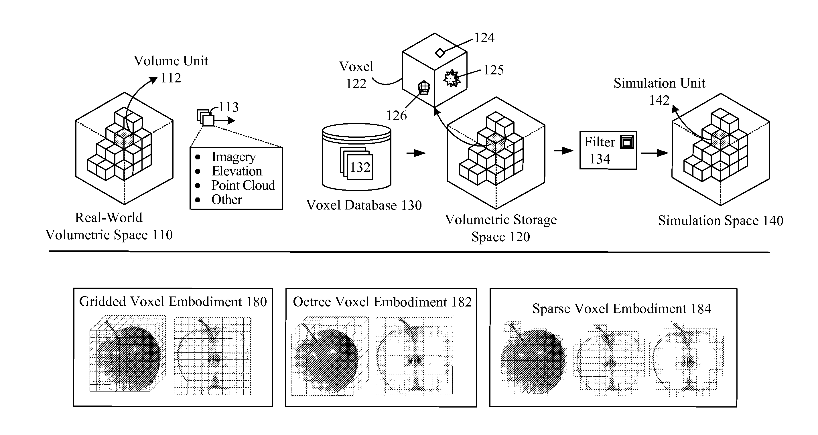
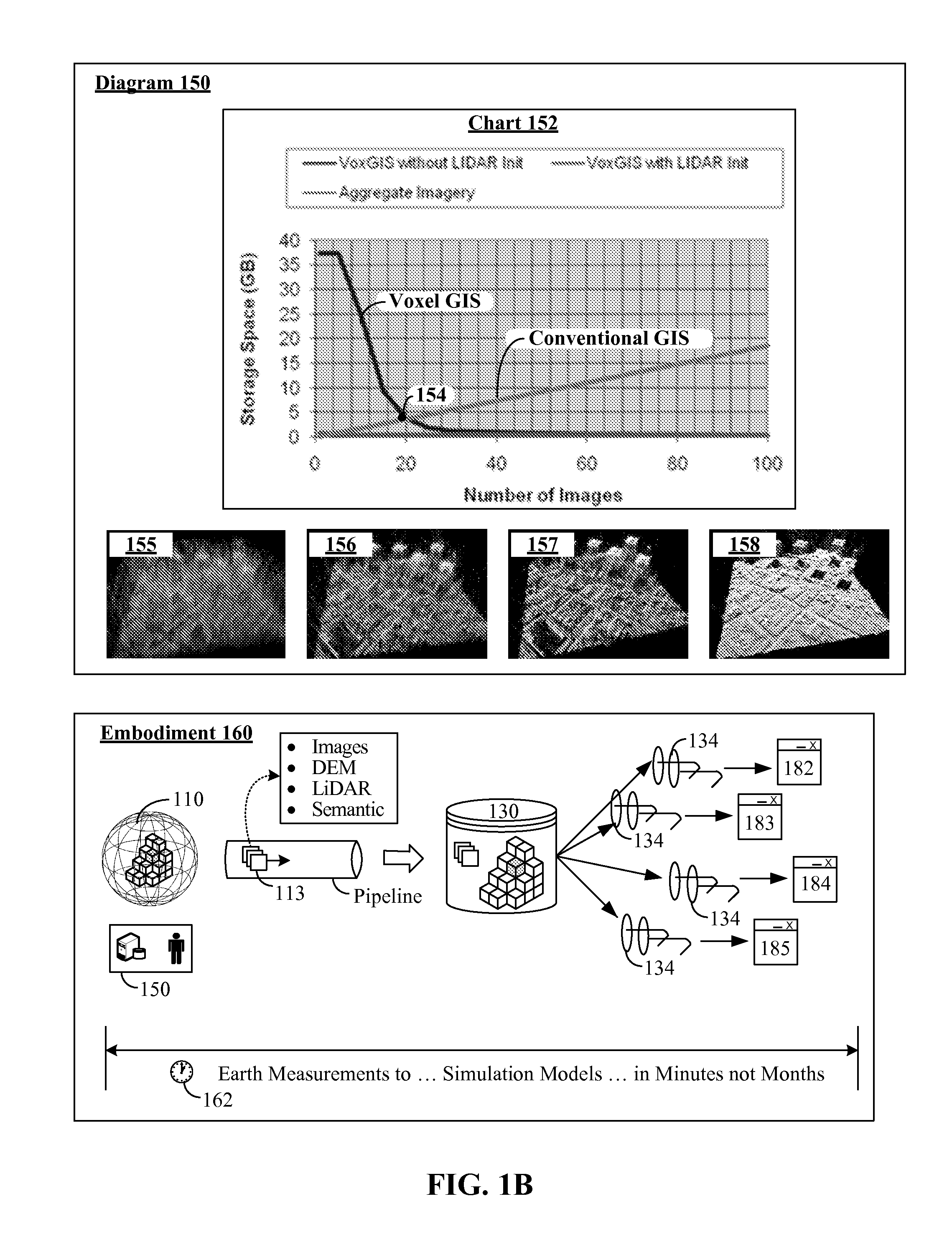
[0035]In one embodiment, the common database 130 product can be a probabilistic one in which uncertainty is handled. In one embodiment, a query engine for the database 130 can include multiple different components for producing different queries (e.g., mission rehearsal query, training query, analysis query, etc.), which handle uncertainty in different manners for different types of consumers. It should be appreciated that embodiment 130 can be largely automated, which permits the process 162 from taking measurements, to producing simulation models to occur within minutes (under thirty minutes or under twenty four hours, for example) and not months, as is the case with conventional information gathering and modeling processes. Thus, in one embodiment, a real world (110) situation can be directly mapped to simulation space 140, in a rapid enough manner to permit users to construct scenarios as part of a mission planning and / or mission rehearsal phase of an engagement. The real world ...

embodiment 160

[0062]Unlike many computing systems, system 400 can be a security sensitive one where data classifications are highly important. That is, information acquired from data sources 150, stored in voxel GIS 440, and used to drive simulation devices 210 can include unclassified, secret, top secret (including compartmentalizations) information. Classification components 404, 415, 424 can exist, which implement comprehensive and conservative rules to automatically classify information into appropriate classifications. Additionally, sanitizers (e.g., sanitizer 426) can be used in system 400 to downgrade semantic content (e.g., from secret to unclassified, for example) of conveyed data elements to ensure that classification based restrictions are not violated. Moreover, different network 460 channels and information handling standards can be imposed based on classification level of the information being conveyed. A further complication is that aggregating and / or analyzing data from different ...


PUM


Abstract

A set of sensors can capture raw data that geospatially corresponds to a real world volumetric space. The raw data can include point cloud data encoded in a light detecting and ranging (LiDAR) information format, imagery and video data, and elevation data encoded in a digital elevation model (DEM) or digital surface model (DSM) format. The real-world volumetric space can be segmented into a set of volumetric units, wherein datum of the raw data is indexed against the volumetric units. Each of the volumetric units of the real-world volumetric space can be mapped to a voxel in a storage volumetric space of a voxel database. The raw data can then be stored and fused in the voxel database such that each voxel in the voxel database represents a combination of volumetrically stored data for all source products that includes providing point cloud data, imagery data, and elevation data.

Description

BACKGROUND[0001]The present disclosure relates to the field of simulation systems, three dimensional user interfaces, and terrain repositories and, more particularly, to a voxel approach to terrain repositories for modeling and simulation.[0002]Polygonal modeling has been the standard in three dimensional modeling and terrain representation for over twenty years. Two common polygonal model based techniques that are conventionally used for terrain include regular triangulated networks (RTNs) and triangulated irregular networks (TINs). Regular Triangulated Networks (RTNs) are a computationally-efficient means of capturing all posts in an elevation raster. Triangulated Irregular Networks (TINs) can provide a more natural terrain appearance than RTNs with fewer polygons. Polygonal modeling has enjoyed wide-spread popularity because of its visual realism and its efficiency (at least for terrain modeling based on terrain sensor data having a resolution of one meter or larger ground separa...

Claims


Application Information

Patent Timeline
Patent Type & Authority Applications(United States)
IPC IPC(8): G06F17/30
CPCG06F17/30241G06F16/29
Inventor SALEMANN, LEO
Owner LOCKHEED MARTIN CORP
Why Eureka
Try Eureka