Methods for road safety enhancement using mobile communication device

a mobile communication and road safety technology, applied in the direction of road vehicles, traffic control systems, instruments, etc., can solve the problem that the accumulation of positioning errors in such short time is not significant to the positioning accuracy needed, and achieves the effect of improving accuracy, facilitating road hazard determination, and being accurate enough

Inactive Publication Date: 2013-04-04
ZHANG WEI
View PDF10 Cites 91 Cited by
  • Summary
  • Abstract
  • Description
  • Claims
  • Application Information

AI Technical Summary

Benefits of technology

[0012]GPS-update-interval speed positioning provides a method to use speed obtained from speedometer of vehicle to calculate latest position in conjunction with road path that the vehicle is moving along during updating time interval of GPS positioning. Because speedometer responds fast to speed variation and is sufficiently accurate, the method can provide up-to-time positioning data starting after one GPS location is measured and ending when next GPS location is measured, then repeating that for next updating time interval of GPS receiver. Since the method only has to calculate vehicle positions during GPS updating time interval, which is typically several seconds, accumulation of positioning error in such short term is insignificant to positioning accuracy needed for purpose of road safety enhancement. The method gives a solution to reliably update vehicle location during update time interval of GPS receiver.
[0013]In accordance with the invention, the disclosure presents a method of vehicle traveling data broadcasting, in which a mobile communication device carried with a vehicle obtains vehicle moving data and broadcasts vehicle traveling data comprising the moving data through radio transmission for nearby vehicle to receive. The mobile communication device obtains vehicle location data from GPS measurement and speed of vehicle through image capturing and recognition of speedometer of the vehicle. Furthermore, the mobile communication device may use GPS-update-interval speed positioning to refresh position data more frequently than GPS update rate. The inter-vehicle sharing of vehicle moving data with accurate speed and high position refreshing rate forms a solid ground of information to achieve reliable and timely responsive road hazard warning for road safety enhancement. Driver's intended or going-on steering action, if available, may be included in the broadcasted messages in additional to the moving data. Driver's intended steering action such as left or right turn indication presented on instrument cluster may be obtained by the MCD using imaging capturing and recognition of instrument cluster. Driver's going-on steering action may be obtained by the MCD, which is placed in such way that it tilts in coupling with steeling wheel rotation, using image capturing of instrument cluster and tilted angle recognition of the captured image.
[0014]In accordance with the invention, the disclosure further presents a method of road hazard early warning, in which a mobile communication device (MCD) carried with a base vehicle receives moving data of nearby vehicle that is broadcasted through radio transmission and keeps tracking moving status of nearby vehicle, and, determine potential collision or other road hazard involving with nearby vehicle according to moving status of base vehicle. Image capturing and processing of speedometer of vehicle by a mobile communication device may be used to get speed of vehicle to facilitate the road hazard determination. Relative positioning map-matching lane correlation may be used to improve accuracy and reliability of road hazard early warning. Driver's currently going-on or intended steering action such as left / right steering or acceleration / deceleration, if available, may be taken account of determining potential road hazard in conjunction with moving data of vehicle. Driver's steering action may be obtained by a mobile communication device (MCD) coupled with movement of steering wheel to capture images of instrumental clusters of vehicle using onboard camera of the MCD and process captured images to detect the movement of steering wheel or speed indication of speedometer. Driver's intended steering action may be obtained by detecting left / right turn indication on instrumental cluster through image capturing and processing thereof. If a potential road hazard is determined, driver is given appropriate warning in audio form, visual form or combination thereof to take avoidance action. Regardless of whether a potential road hazard is found or not, the method may present location of nearby vehicle relative to base vehicle in either audio form, visual form or combination thereof in order for driver to get better situation awareness of nearby road usage. Audio form may be provided through either onboard speaker of the MCD or an external speaker coupled with the MCD. Visual form may be provided on either display screen of the MCD or an external display coupled with the MCD, such as vehicle mounted display, HUD (head up display), display of other device, and so on.
[0015]In accordance with the invention, the disclosure further presents a method of driving action warning, in which a mobile communication device (MCD) on board a base vehicle detects driver's driving action through image capturing and recognition of instrument cluster of base vehicle and evaluate potential road hazard or collision to be caused by the driving action by analyzing the driving action in conjunction with traveling status of base vehicle and nearby vehicles. Once driver's driving action is found dangerous, the MCD is to immediately alert driver to correct the driving action. The method is advantageous in avoiding driver initiated road hazard.
[0016]In accordance with the invention, the disclosure further presents a method of road navigation enhancement, in which a mobile communication device on board a base vehicle may perform relative positioning map-matching lane correlation by utilizing position data of nearby vehicle received through inter-vehicle communication to determine lane location of base vehicle and / or GPS-update-interval speed positioning to get more timely updated position data of base vehicle, and, then, use the lane location and / or the timely updated position data to enhance road navigation. With lane location available, road navigation can give driver more precise and more detailed steering instruction. With position data refreshed more frequently, road navigation is more responsive to give corrective road guidance when incompliance to road guidance occurs. The method may also use driver's steering action such as left / right steering or acceleration / deceleration, if available, to enhance road navigation. Driver's steering action may be obtained by a mobile communication device (MCD) coupled with movement of steering wheel to capture images of instrumental cluster of vehicle using onboard camera of the MCD and process captured images to detect the movement of steering wheel or speed indication of speedometer. Analyzing continuous steering actions over a time span after initialization can determine whether vehicle is making lane shift, road turn, or other change of movement. The method allows real time response of road navigation to driver's steering action. Furthermore, driver's driving action including acceleration / deceleration, intended left / right steering indicated by indication of left / right turn signal, and going-on steering action indicated by steering wheel rotation may be used to determine driving compliance to navigation instructions and notify driver to correct if noncompliance is found.

Problems solved by technology

Since the method only has to calculate vehicle positions during GPS updating time interval, which is typically several seconds, accumulation of positioning error in such short term is insignificant to positioning accuracy needed for purpose of road safety enhancement.

Method used


Image

  • Methods for road safety enhancement using mobile communication device
  • Methods for road safety enhancement using mobile communication device
  • Methods for road safety enhancement using mobile communication device

Examples


Embodiment Construction

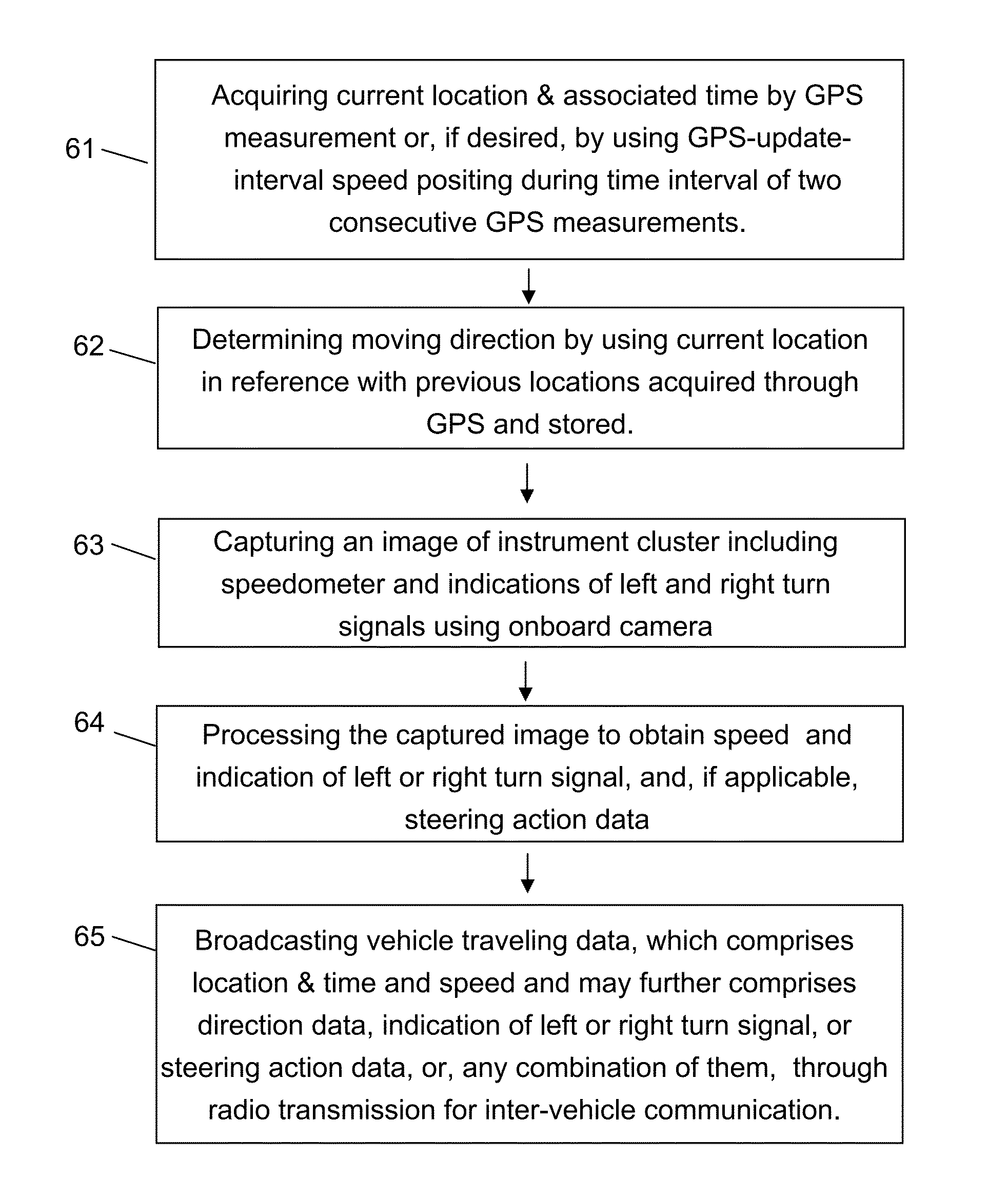
[0032]In accordance with the invention, principle of GPS-update-interval speed positioning is to use speed data of vehicle in conjunction with road path data of digital roadmap to calculate positions of vehicle between two consecutive GPS measurements. Fundamental of the principle is to, during GPS update interval, correlate vehicle movement along road path calculated by speed and very small time interval with available GPS measurement to determine location of vehicle in GPS coordinates or other geographic coordinates. For a GPS update interval, the speed positioning starts from an entry point on the road path that corresponds to an entry location. At beginning of GPS update interval, the entry location is latest GPS measured location. The entry point may be determined as the closest point on the road path to the GPS measured location because, due to limited positioning accuracy of GPS measurement, GPS location often falls close to by not right on the road path. Other sophisticated ...


PUM


Abstract

Methods for road safety enhancement use mobile communication device (MCD) onboard vehicle to share traveling data through inter-vehicle communication broadcasting, perform road hazard warning, enhance road navigation, and provide autonomous road assistance. The methods have a variety of vehicle status data, such as moving data, steering data, or indicator data, obtained through GPS or image capturing and recognition of instrument cluster of vehicle. The image capturing and recognition allows to get speed data from indication of speedometer, indication of left or right turn signal, steering action data corresponding to steering wheel rotation, and light-on indication of system status indicators. To facilitate that, the MCD may be placed in front of steering wheel, and, if applicable, also in coupling with movement of steering wheel. The MCD may perform relative positioning map-matching lane correlation and GPS-update-interval speed positioning to improve data quality regarding vehicle moving status.

Description

CROSS-REFERENCE TO RELATED APPLICATIONS[0001]The present application claims the benefit of U.S. Provisional Application Ser. No. 61 / 542,794 filed by Wei Zhang on Oct. 3, 2011, which is incorporated herein by reference.STATEMENT REGARDING FEDERALLY SPONSORED RESEARCH OR DEVELOPMENT[0002]Not applicable.FIELD OF THE INVENTION[0003]The present invention relates to road safety of ground vehicle involving GPS based road navigation, vehicle collision avoidance through inter-vehicle communication, and road emergency assistance.BACKGROUND OF THE INVENTION[0004]To improve driving safety, remote sensors are installed on some vehicles to detect presence of nearby road objectives, primarily other vehicles. Once a road objective is detected and identified by control system of the sensors as potential threat to driving safety, the control system coupled with vehicle driving system may control the vehicle to act properly such as braking to avoid a possible collision. The control system may also ale...

Claims


Application Information

Patent Timeline
Patent Type & Authority Applications(United States)
IPC IPC(8): G01S19/48G08G1/01
CPCG01S5/0072G01S19/48G07C5/085G08G1/167G07C5/008G08G1/163
Inventor ZHANG, WEI
Owner ZHANG WEI
Why Eureka
Try Eureka