System and method for using global navigation satellite system (GNSS) navigation and visual navigation to recover absolute position and attitude without any prior association of visual features with known coordinates

a global navigation satellite and absolute position technology, applied in the field of navigation systems, can solve the problems of not having much commercial application value, difficult to create augmented visuals that provide a convincing illusion of realism, and a constant disappointment of ar, so as to achieve precise and absolute position and orientation of devices, precise and accurate absolute registration, robust and accurate

Inactive Publication Date: 2015-08-06
BOARD OF RGT THE UNIV OF TEXAS SYST
View PDF31 Cites 93 Cited by
  • Summary
  • Abstract
  • Description
  • Claims
  • Application Information

AI Technical Summary

Benefits of technology

[0041]The present invention provides a methodology by which visual feature and carrier-phase GNSS measurements can be coupled to provide precise and absolute position and orientation of a device. The primary advantage of this coupling that has not been exploited in prior work is the recovery of precise absolute orientation without the use of an IMU and a magnetometer. This advantage addresses one of the largest challenges in the augmented reality field today: robust, precise, and accurate absolute registration of virtual objects onto the real-world without the use of fiduciary markers or a high-quality IMU / magnetometer.
[0042]Features of the present invention include, but are not limited to: does not require a map of visual feature locations in advance because a map of the environment is generated on-the-fly; obtains precise and accurate absolute position and orientation from only visual feature and carrier phase GNSS measurements; maintains precise and accurate absolute positioning and orientation during periods of GNSS unavailability; provides precise and accurate absolute positioning and orientation to the augmented reality engine; and can use inexpensive commercially available cameras and GNSS receivers. Not all of these features are required. Additional features can be provided as will be appreciated by those skilled in the art.

Problems solved by technology

AR has been a perennial disappointment since the term was first coined 23 years ago by Tom Caudell.
There have been technological advances in AR, but, with all the promise of AR, it simply has not gained much traction in the commercial world.
The answer is that creating augmented visuals that provide a convincing illusion of realism is extremely difficult.
Thus, AR has either suffered from poor alignment of the virtual elements and the real world, resulting in an unconvincing illusion, or has been limited in application to avoid this difficulty.
Registration errors are a direct result of the estimation error of the user's position and orientation relative to the virtual element.
These registration errors have been the primary limiting factor in the suitability of AR for various applications [6].
If registration errors are too large, then it becomes difficult or even impossible to interact with the virtual objects because the object may not appear stationary as the user approaches.
This is because registration errors become more prominent in the user's view of the object as the user gets closer to the virtual object due to user positioning errors.
While there is utility to these applications, they seem disappointing when compared to Wellner's vision of a fully immersive AR experience.
However, these techniques are not generally applicable.
Relative navigation alone does not provide any global reference, which is necessary for many applications and convenient for others.
Currently, the price of commercially available CDGPS-capable receivers is out of reach for the typical consumer.
Each additional satellite constellation and signal frequency adds significant cost to the receiver.
The concession of reducing signal diversity to maintain price, however, exacerbates problems with GPS availability.
GPS reception is too weak for indoor navigation and is difficult in urban canyons.
Multiple constellations could help with urban canyons, but indoor navigation with GPS alone is a difficult problem.
However, a coupled CDGPS and INS navigation system provides poor attitude estimates during dynamics and near magnetic disturbances.
Additionally, the position solution of a coupled CDGPS and INS navigation system drifts quickly during periods of GPS unavailability for all but the highest-quality IMUs, which are large and expensive.
These applications typically rely on visual cues or pattern recognition for relative navigation, but there are some applications that leverage absolute pose which do not have as stringent accuracy requirements as those envisioned for the ideal AR system.
Word Lens: Tourists to foreign countries often have trouble finding their way around because the signs are in foreign languages.
However, Glass makes no attempt toward improving registration accuracy over existing consumer AR.
The positioning of this technique was reported as accurate to meter-level, which would result in large registration errors for a virtual object within a meter of the user.
Decimeter-level positioning accuracy was obtained in this example, which would still result in large registration errors for a virtual object within a meter of the user.
This method also does not scale well as it would require a dense network of markers to be placed everywhere an AR system would be operated.
While the PhotoSynth approach seems to satisfy the accuracy requirements of an ideal AR system, there are several problems to universal availability.
However, the area covered by these teams is insignificant when it comes to mapping the whole world.
Second, the world would have to be mapped over again as the environment changes.
This requires a significant amount of management of an enormously large database.
Third, applications that operate in changing environments, such as construction, could not use this technique.
In addition to being a hassle for users, this could also create privacy issues if these images had to be incorporated into a public database to be usable with AR applications.
Communications bandwidth would also be a severe limitation to the proliferation of AR using this technique.
The fact that the GPS antenna is not rigidly attached to the IMU and display also severely limits the potential accuracy of this AR system configuration even if the positioning accuracy of the GPS receiver was improved.
However, no quantitative analysis of the system's accuracy was presented.
This AR system restricts the user to applications with an open sky view, since it cannot produce position estimates in the absence of GPS.
In a dynamic scenario, the CDGPS position solution would also suffer from the unknown user dynamics.
Although their initial prototype only used SPS GPS and an IMU, much effort was spent in designing software to provide convincing visualizations of the subsurface infrastructure and on the ergonomics of the device.
This system does not fully couple CDGPS and visual SLAM.
There has been some prior work on coupling visual navigation and GPS, but these techniques only coupled the two in some limited fashion.
In fact, Schall's filter leaves attitude estimation and position estimation decoupled and does not use accelerometer measurements from the IMU for propagating position between GPS measurements.
This approach limits the absolute attitude accuracy of the filter to that of the IMU.

Method used


Image

  • System and method for using global navigation satellite system (GNSS) navigation and visual navigation to recover absolute position and attitude without any prior association of visual features with known coordinates
  • System and method for using global navigation satellite system (GNSS) navigation and visual navigation to recover absolute position and attitude without any prior association of visual features with known coordinates
  • System and method for using global navigation satellite system (GNSS) navigation and visual navigation to recover absolute position and attitude without any prior association of visual features with known coordinates

Examples


Embodiment Construction

[0076]While the making and using of various embodiments of the present invention are discussed in detail below, it should be appreciated that the present invention provides many applicable inventive concepts that can be embodied in a wide variety of specific contexts. The specific embodiments discussed herein are merely illustrative of specific ways to make and use the invention and do not delimit the scope of the invention.

[0077]A system and method for using carrier-phase-based satellite navigation and visual navigation to recover absolute and accurate position and orientation (together known as “pose”) without an a priori map of visual features is presented. “Absolute” means that an object's pose is determined relative to a global coordinate frame. Satellite navigation means that one or more Global Navigation Satellite Systems (GNSS) are employed. A priori map of visual features means that the system has no prior knowledge of its visual environment; i.e., it has no prior associati...


PUM


Abstract

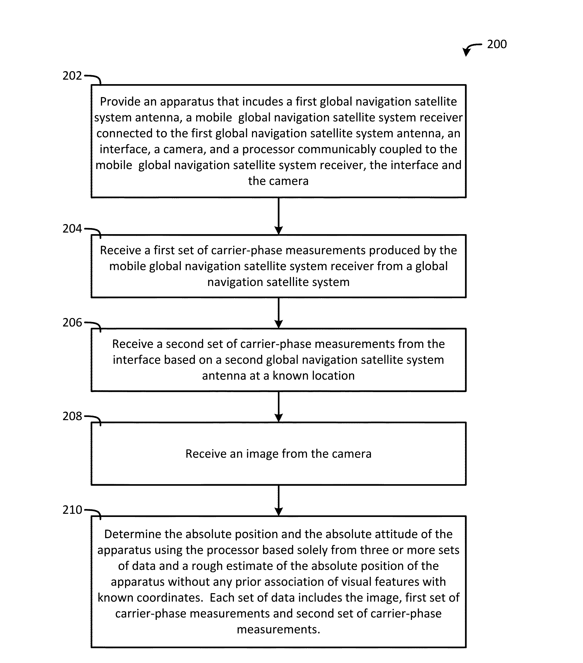
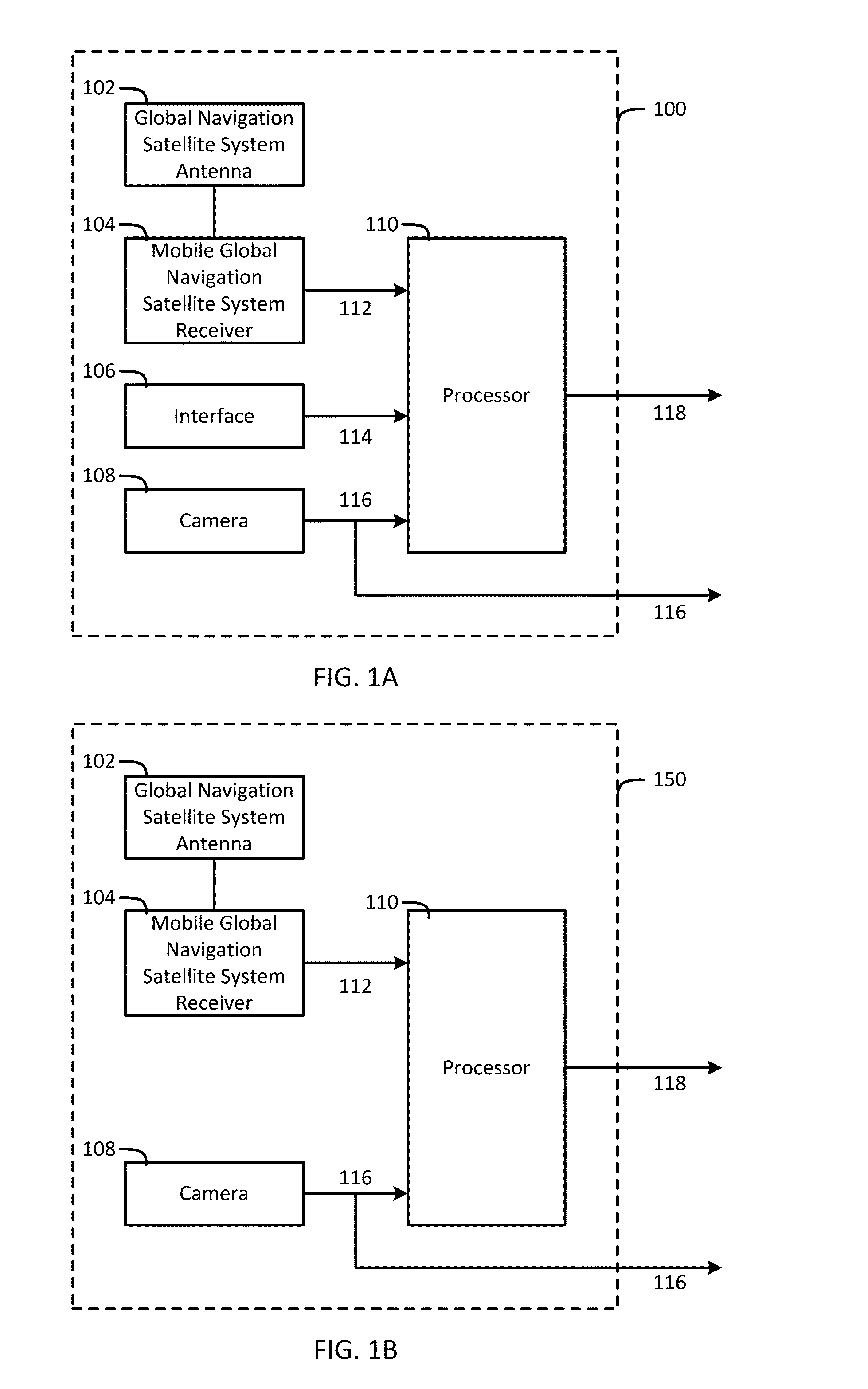
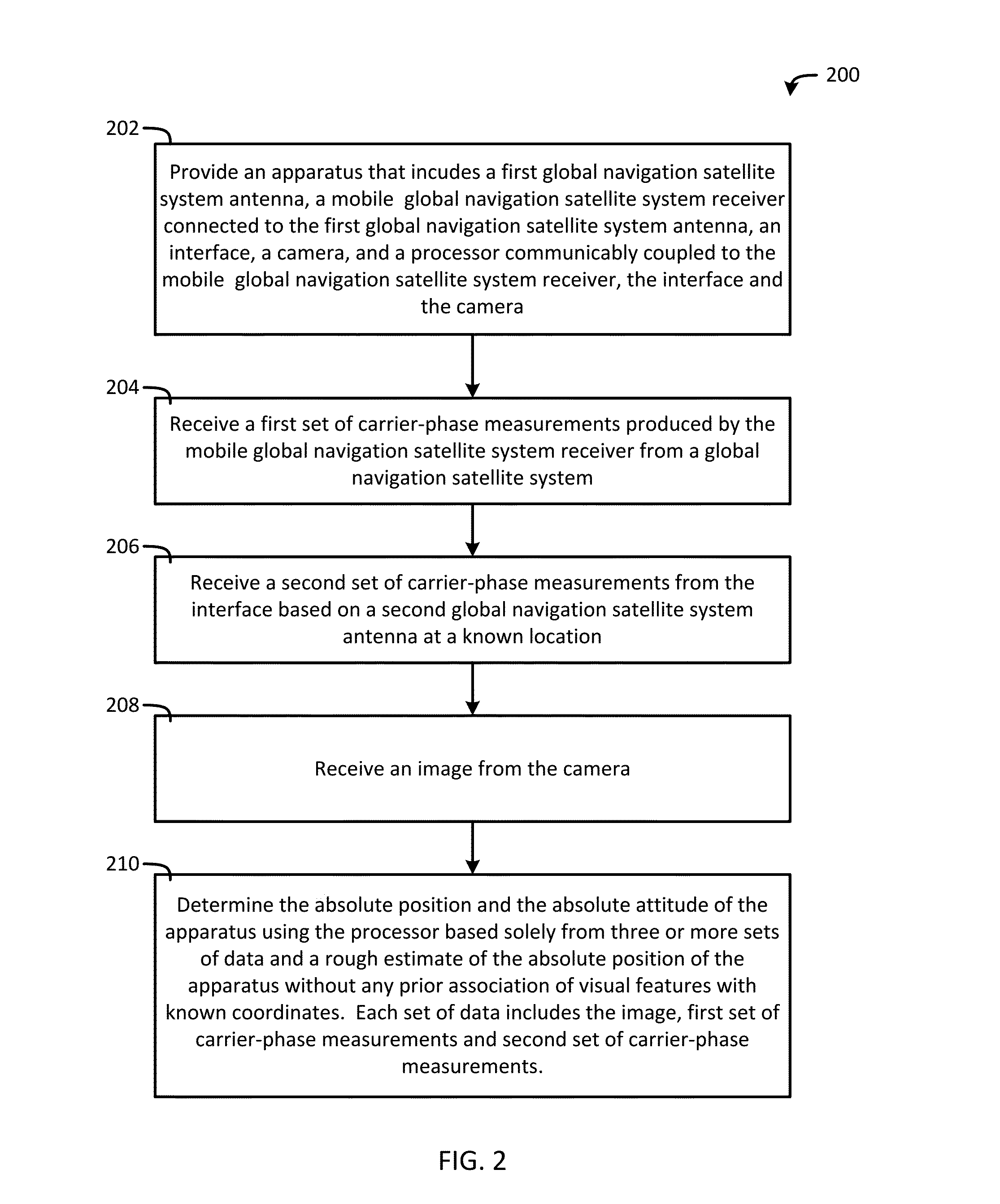
An apparatus includes a global navigation satellite system antenna, a global navigation satellite system receiver, a camera, and a processor. The mobile global navigation satellite system receiver produces a set of carrier-phase measurements from a global navigation satellite system. The camera produces an image. The processor determines an absolute position and an absolute attitude of the apparatus solely from three or more sets of data and a rough estimate of the absolute position of the apparatus without any prior association of visual features with known coordinates. Each set of data includes the image and the set of carrier-phase measurements. In addition, the processor uses either a precise orbit and clock data for the global navigation satellite system or another set of carrier-phase measurements from another global navigation satellite system antenna at a known location in each set of data.

Description

CROSS-REFERENCE TO RELATED APPLICATIONS[0001]This application claims benefit of U.S. Provisional Application Ser. No. 61 / 935,128 filed Feb. 3, 2014 which is incorporated herein by reference in its entirety.STATEMENT REGARDING FEDERALLY SPONSORED RESEARCH OR DEVELOPMENT[0002]Not Applicable.THE NAMES OF PARTIES TO A JOINT RESEARCH AGREEMENT[0003]Not Applicable.STATEMENT OF FEDERALLY FUNDED RESEARCH[0004]Not Applicable.INCORPORATION-BY-REFERENCE OF MATERIAL SUBMITTED ON A COMPACT DISC[0005]Not Applicable.FIELD OF THE INVENTION[0006]The present invention relates generally to the field of navigation systems and, more particularly, to a system and method for using global navigation satellite system (GNSS) navigation and visual navigation to recover an absolute position and attitude of an apparatus without any prior association of visual features with known coordinates.BACKGROUND OF THE INVENTION[0007]Augmented reality (AR) is a concept closely related to virtual reality (VR), but has a fu...

Claims


Application Information

Patent Timeline
Patent Type & Authority Applications(United States)
IPC IPC(8): G01S19/43G01S19/54G01S19/49
CPCG01S19/43G01S19/54G01S19/49G01S19/485
Inventor HUMPHREYS, TODD E.SHEPARD, DANIEL P.PESYNA, JR., KENNETHBHATTI, JAHSHAN
Owner BOARD OF RGT THE UNIV OF TEXAS SYST
Why Eureka
Try Eureka