Map data generation system and method for generating map data

a map data and data generation technology, applied in the field of map data generation technology, to achieve the effect of increasing the compression rate of map data and reducing the volume of data

Active Publication Date: 2019-02-28
MITSUBISHI ELECTRIC CORP
View PDF0 Cites 1 Cited by
  • Summary
  • Abstract
  • Description
  • Claims
  • Application Information

AI Technical Summary

Benefits of technology

[0010]According to the above-mentioned one aspect, the error evaluation formula contains a slope error evaluation component and an altitude error evaluation component. Therefore, an obtained approximation formula not only enables precise calculation of a slope value at an arbitrary point on the target route, but also enables precise calculation of an altitude value through integration of the calculated highly-precise slop

Problems solved by technology

However, three-dimensional shape information such as the road center line may have a large da

Method used


Image

  • Map data generation system and method for generating map data
  • Map data generation system and method for generating map data
  • Map data generation system and method for generating map data

Examples


first embodiment

[0022]

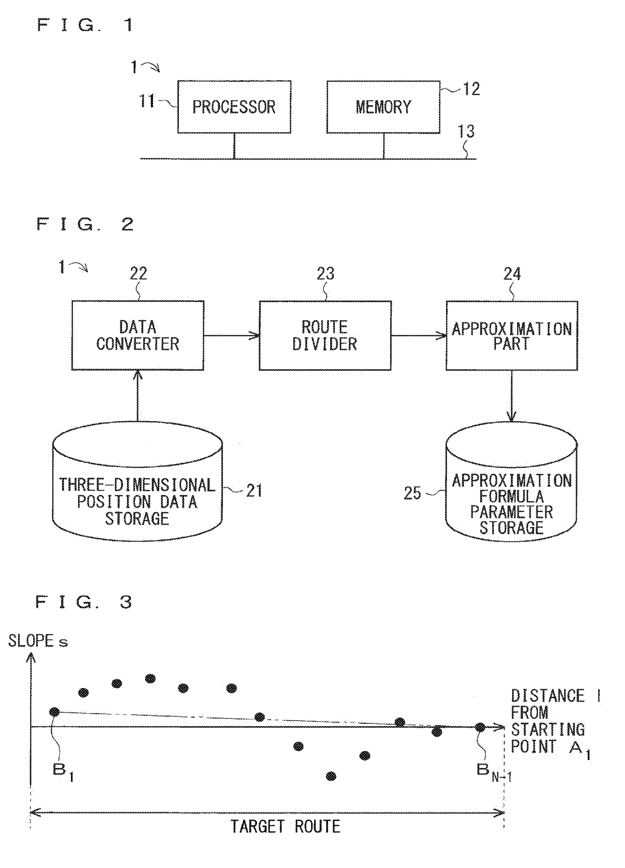
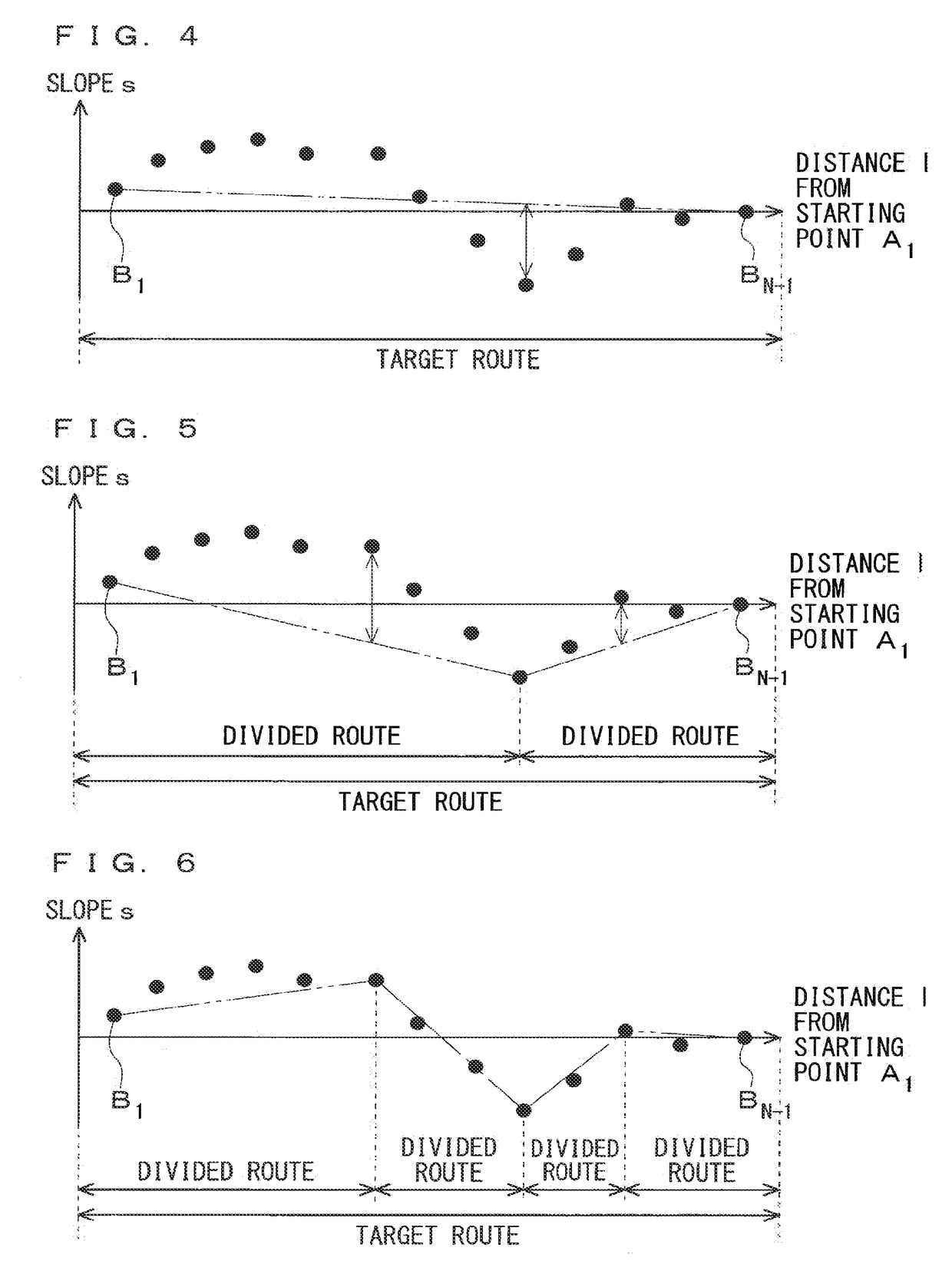
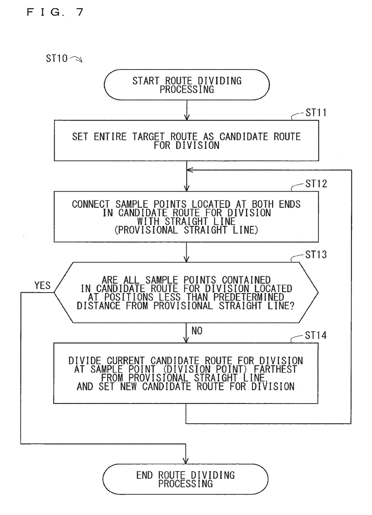
[0023]FIG. 1 is a hardware configuration diagram of a map data generation system 1 according to a first embodiment and also according to second and third embodiments to be described later. The map data generation system 1 is, for example, used by a business entity that generates map data. Alternatively, the map data generation system 1 is used by being incorporated into a navigation system installed in a movable body, such as an automobile.

[0024]According to the example of FIG. 1, the map data generation system 1 includes a processor 11 and memory 12, and the processor 11 and the memory 12 are connected via a bus 13. The memory 12 is made up of one or more storage devices. Examples of the storage device include semiconductor memory (such as read only memory (ROM), random access memory (RAM), rewritable non-volatile memory) and a hard disk (HD) device. The memory 12 may include both of semiconductor memory and a HD device.

[0025]According to the configuration of FIG. 1, the proc...

second embodiment

[0085]The slope data is, for example, used for an early estimation of the amount of regenerative electric power in an electric vehicle and a hybrid vehicle. If the amount of regenerative electric power is understood in advance, a possible travel distance may be accurately calculated. Further, how to achieve the most efficient traveling may be determined by determining intervals to be traveled with gasoline and intervals to be traveled with electric power.

[0086]Regenerative electric power is generated only when a braking operation is performed intensely exceeding a certain degree of intensity. Thus, estimation of regenerative electric power is carried out for an interval having such downward slope that is larger than a certain reference slope value. Therefore, an approximation formula for calculating a slope value is required to have high calculation precision in such an interval.

[0087]In view of the above, in the second embodiment, the formula (13) below is used as the error evaluat...

third embodiment

[0098]The slope data is, for example, used for estimation of a current position of a subject vehicle (hereinafter also referred to as a subject vehicle position). Specifically, the subject vehicle position may be specified on a map by comparing slope of a road (that is contained in map data) and inclination of the subject vehicle (that is measured by an inclination sensor or the like). In this case, the subject vehicle position may be accurately specified on condition that the slope value and the inclination value are accurate.

[0099]Note that, with use of a GPS device, a map matching technology (a technology of correcting the subject vehicle position on the basis of a general fact that an automobile should travel on a road, for example), etc., the subject vehicle position may be in many cases accurately estimated without use of the slope data. However, it is difficult to detect the subject vehicle position using a GPS device when the circumstance of GPS reception is not good (in a t...


PUM


Abstract

A slope sample value at a sample point on a target route and a distance sample value from a reference point on the target route to the sample point are calculated based on three-dimensional position data of the target route. Undetermined elements contained in a model formula for the approximation formula representing relation between the slope sample value and the distance sample value are determined using an error evaluation formula for the model formula. The error evaluation formula contains a slope error evaluation component for evaluating a slope error between the slope sample value and a slope model value that is calculated using the model formula, and an altitude error evaluation component for evaluating an altitude error between an altitude model value that is obtained through integration of the slope model value and an altitude value that is obtained from the three-dimensional position data.

Description

TECHNICAL FIELD[0001]The present invention relates to a technology of generating map data.BACKGROUND ART[0002]In recent years, a mobile mapping system (MMS) has been increasingly used, which acquires three-dimensional point group information, such as a road surface and roadside equipment, simultaneously with traveling of a surveying vehicle. Note that, the surveying vehicle is equipped with surveying functions, such as a global positioning system (GPS) device, a laser radar, and a camera.[0003]Acquired three-dimensional point group information as it is has a very large data volume, and thus processing of extracting only necessary pieces of information is performed. For example, as for an in-vehicle device, three-dimensional positions and three-dimensional shapes, such as a central position of a road (hereinafter also referred to as a “road center line”), a central position of each traffic lane on a road (hereinafter also referred to as a “traffic lane center line”), a sectioning lin...

Claims


Application Information

Patent Timeline
IPC IPC(8): G01C21/32G06F17/30G01C21/34
CPCG01C21/32G06F16/29G01C21/34G06T11/60G09B29/00G09B29/106G06T17/05G01C21/3822
Inventor WATANABE, MASASHIKAMEI, KATSUYUKIFUJIBAYASHI, HIROYUKI
Owner MITSUBISHI ELECTRIC CORP
Why Eureka
Try Eureka