Multiple Resolution, Simultaneous Localization and Mapping Based On 3-D LIDAR Measurements

a lidar and point cloud technology, applied in the field of multi-resolution, simultaneous localization and mapping based on 3-d lidar measurement, can solve the problems of limited application to well controlled indoor environments, slow moving operational scenarios, and inability to accurately map and localize objects, so as to reduce the amount of data associated with each image frame, improve computational efficiency, and maintain both mapping and localization accuracy

Pending Publication Date: 2019-03-14
VELODYNE LIDAR USA INC
View PDF0 Cites 30 Cited by
  • Summary
  • Abstract
  • Description
  • Claims
  • Application Information

AI Technical Summary

Benefits of technology

[0011]In one aspect, LIDAR image frames are segmented and clustered before feature detection. The detected features are employed to perform SLAM analysis. Performing segmentation and clustering before feature detection improves computational efficiency while maintaining both mapping and localization accuracy for an autonomous vehicle application.
[0012]Segmentation involves removing redundant data before feature extraction. In this manner, each image frame includes high resolution data only in the region of interest (ROI) and lower resolution in regions that are sufficiently well described with fewer pixels, or none at all. In one example, segmentation involves eliminating redundant points associated with the ground plane. By reducing the number of pixels in each image frame, the amount of data associated with each image frame is reduced.
[0021]In another aspect, groups of pixels associated with similar objects are clustered to reduce the computational complexity of subsequent feature detection operations. In this manner, feature detection is performed on pixel data associated with one object, rather than many objects.
[0023]In one embodiment, features are quickly detected from LIDAR image frames based on values of the reflectivity gradient. The reflectivity gradient is a bounded integer and these values can be sorted efficiently.

Problems solved by technology

However, this approach is often limited to well controlled, indoor environments or slow moving operational scenarios which are not consistent with actual driving conditions.

Method used


Image

  • Multiple Resolution, Simultaneous Localization and Mapping Based On 3-D LIDAR Measurements
  • Multiple Resolution, Simultaneous Localization and Mapping Based On 3-D LIDAR Measurements
  • Multiple Resolution, Simultaneous Localization and Mapping Based On 3-D LIDAR Measurements

Examples


Embodiment Construction

[0037]Reference will now be made in detail to background examples and some embodiments of the invention, examples of which are illustrated in the accompanying drawings.

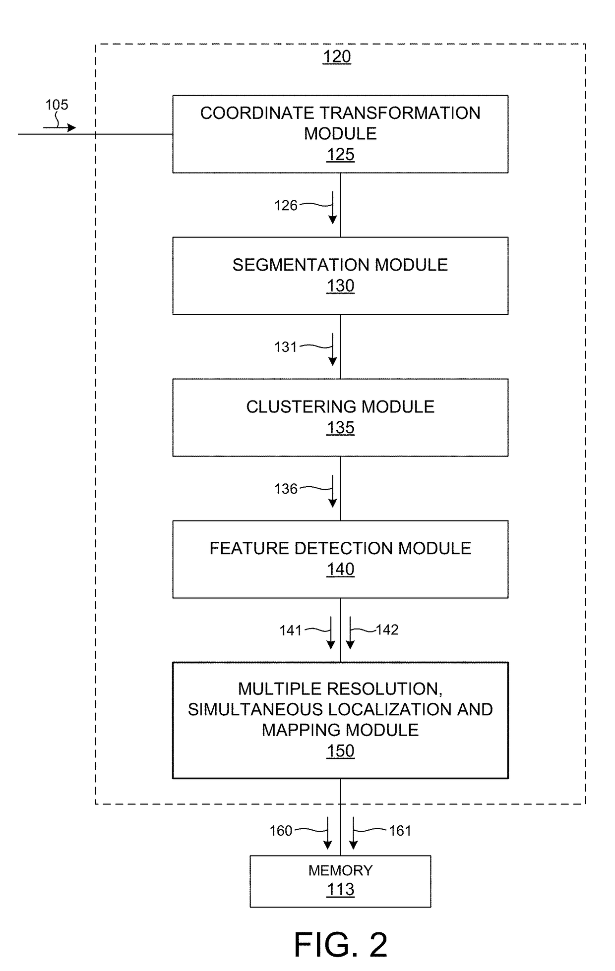
[0038]Methods and systems for improved simultaneous localization and mapping based on 3-D LIDAR image data are presented herein.

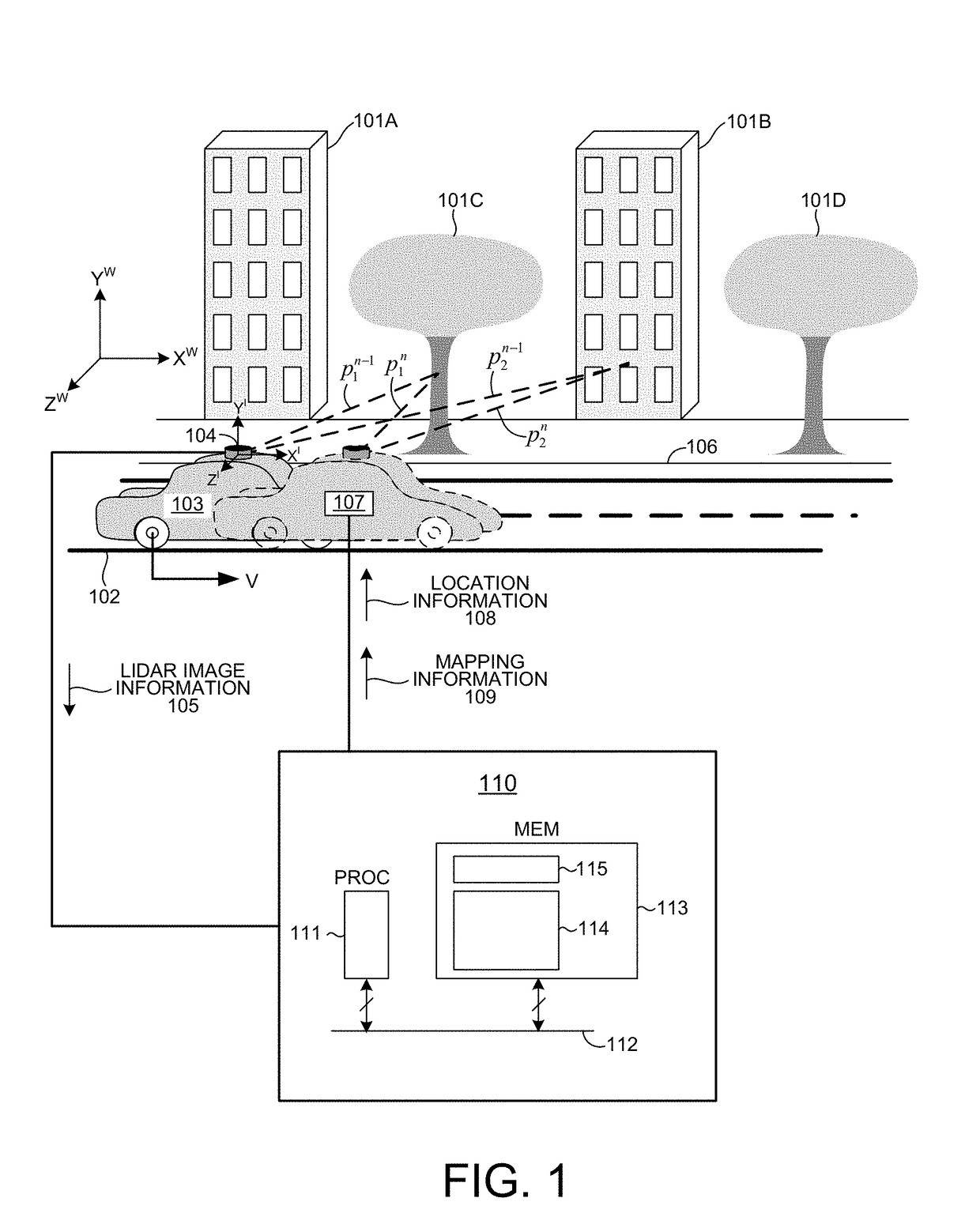
[0039]Simultaneous localization and mapping (SLAM) involves building a consistent three dimensional geometric map of the environment traversed by a LIDAR measurement system while estimating the position of the LIDAR measurement system within the environment in six degrees of freedom (e.g., x, y, z, Rx, Ry, Rz) in real time. SLAM analysis is performed based on the point cloud distance measurement data generated by a LIDAR measurement system.

[0040]FIG. 1 depicts an operational scenario including a LIDAR based, three dimensional imaging system 104 and a computing system 110 configured to simultaneously map the surrounding environment and locate the LIDAR measurement system 104 within the environ...


PUM


Abstract

Methods and systems for improved simultaneous localization and mapping based on 3-D LIDAR image data are presented herein. In one aspect, LIDAR image frames are segmented and clustered before feature detection to improve computational efficiency while maintaining both mapping and localization accuracy. Segmentation involves removing redundant data before feature extraction. Clustering involves grouping pixels associated with similar objects together before feature extraction. In another aspect, features are extracted from LIDAR image frames based on a measured optical property associated with each measured point. The pools of feature points comprise a low resolution feature map associated with each image frame. Low resolution feature maps are aggregated over time to generate high resolution feature maps. In another aspect, the location of a LIDAR measurement system in a three dimensional environment is slowly updated based on the high resolution feature maps and quickly updated based on the low resolution feature maps.

Description

CROSS REFERENCE TO RELATED APPLICATION[0001]The present application for patent claims priority under 35 U.S.C. § 119 from U.S. provisional patent application Ser. No. 62 / 558,256 entitled “Multiple Resolution, Simultaneous Localization And Mapping Based On 3-D LIDAR Measurements,” filed Sep. 13, 2017, the subject matter of which is incorporated herein by reference in its entirety.TECHNICAL FIELD[0002]The described embodiments relate to LIDAR based 3-D point cloud measuring systems, and more specifically, efficient mapping of the measured environment and localization of the LIDAR measurement system.BACKGROUND INFORMATION[0003]LIDAR systems employ pulses of light to measure distance to an object based on the time of flight (TOF) of each pulse of light. A pulse of light emitted from a light source of a LIDAR system interacts with a distal object. A portion of the light reflects from the object and returns to a detector of the LIDAR system. Based on the time elapsed between emission of t...

Claims


Application Information

Patent Timeline
Patent Type & Authority Applications(United States)
IPC IPC(8): G01S17/89G01S7/481G01S17/32G01S17/10G01S17/34
CPCG01S17/89G01S7/4817G01S17/325G01S17/10G01S17/42G01S7/4808G01S17/34
Inventor GUNNAM, KIRAN K.
Owner VELODYNE LIDAR USA INC
Why Eureka
Try Eureka