Analysis of point cloud data using depth and texture maps

Active Publication Date: 2019-08-29
NVIDIA CORP
View PDF10 Cites 8 Cited by
  • Summary
  • Abstract
  • Description
  • Claims
  • Application Information

AI Technical Summary

Problems solved by technology

Processing LiDAR data for real-time localization has proven difficult, in part because improvements in LiDAR resolution have been introduced, causing an increase in the amount of data ne

Method used


Image

  • Analysis of point cloud data using depth and texture maps
  • Analysis of point cloud data using depth and texture maps
  • Analysis of point cloud data using depth and texture maps

Examples


Embodiment Construction

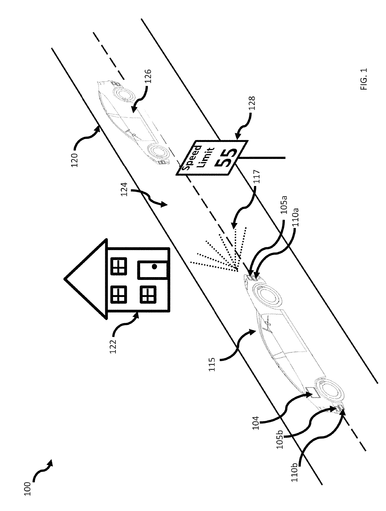
[0015]In the self-driving, e.g., autonomous or semi-autonomous, vehicle industry, the examination of a vehicle's surrounding environment, or geometric space, can result in a collection of a large amount of three dimensional (3D) data points. The data points can be organized as a cloud of data points, i.e., a point cloud, as the data generally represents the space around the vehicle, i.e., a 3D perspective of the geometric space surrounding, or partially surrounding, a vehicle. The vehicle can be of various types of vehicles that are capable of operating with minimal or no human intervention, for example, without limitation, automobiles, box trucks, trucks with trailers, drones, ATVs, robotics, indoor robots, airplanes, rockets, missiles, spacecraft, and other types of vehicles. An example of such a vehicle is shown in FIG. 1.

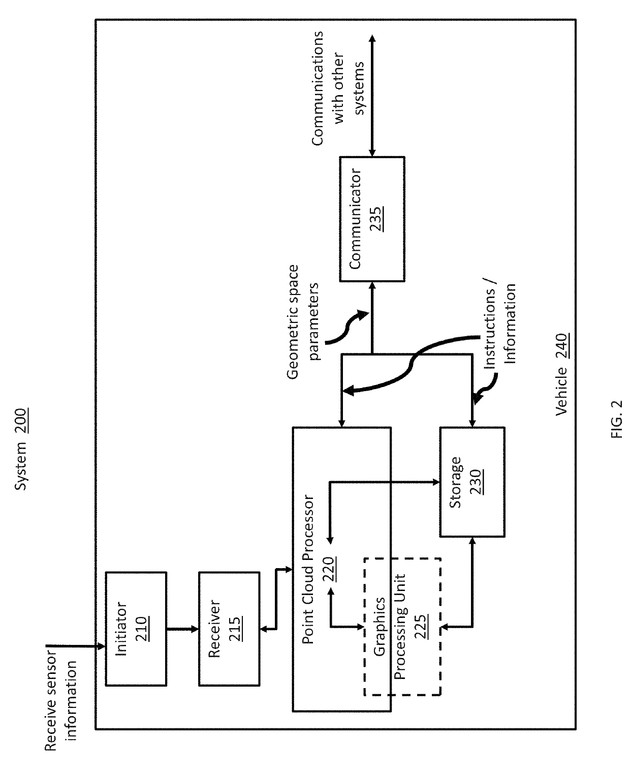
[0016]Various types of data collection technologies or systems can be used, in different combinations, to periodically collect data in a 3D space. For example, ...


PUM


Abstract

Various types of systems or technologies can be used to collect data in a 3D space. For example, LiDAR (light detection and ranging) and RADAR (radio detection and ranging) systems are commonly used to generate point cloud data for 3D space around vehicles, for such functions as localization, mapping, and tracking. This disclosure provides improvements for processing the point cloud data that has been collected. The processing improvements include analyzing point cloud data using trajectory equations, depth maps, and texture maps. The processing improvements also include representing the point cloud data by a two dimensional depth map or a texture map and using the depth map or texture map to provide object motion, obstacle detection, freespace detection, and landmark detection for an area surrounding a vehicle.

Description

CROSS-REFERENCE TO RELATED APPLICATION[0001]This application claims the benefit of U.S. Provisional Application Ser. No. 62 / 636,117, filed by Kulkarni, et al. on Feb. 27, 2018, entitled “TEMPORAL FUSION AND PLANARIZATION FOR ITERATIVE CLOSEST POINT IN AUTOMOTIVE LIDAR APPLICATIONS,” commonly assigned with this application and incorporated herein by reference.TECHNICAL FIELD[0002]This application is directed, in general, to analyzing clouds of points, such as data collected by a light detection and ranging (LiDAR) system, and, more specifically, to transforming point cloud data to a depth map and texture map.BACKGROUND[0003]The iterative closest point (ICP) algorithm is a well-known approach to solving for pose-differences between clouds of points. It is used as an approach to transform LiDAR information in autonomous vehicles, to provide localization, tracking, and other parameters. ICP algorithms utilize the construct of nearest neighbors for identifying groups of points. A common ...

Claims


Application Information

Patent Timeline
IPC IPC(8): G06T7/30G06T15/04G01S17/89G06K9/00G01S17/931
CPCG06T7/30G06T15/04G06T2207/10028G06K9/00791G01S17/89G06T2207/30241G06T7/20G01S17/931G01S17/58G06V20/58G06V2201/12G06T11/001G06T7/521G06V20/56G06V20/582G06V20/584
Inventor KULKARNI, ISHWAREDEN, IBRAHIMKROEPFL, MICHAELNISTER, DAVID
Owner NVIDIA CORP
Why Eureka
Try Eureka