Satellite tomography of rain and motion via synthetic aperture

a satellite tomography and synthetic aperture technology, applied in the field of satellite tomography of precipitation and motion, can solve the problems of large radar instruments, large earth's surface unobserved by these radar systems, and large current space-based precipitation radar systems,

Active Publication Date: 2020-05-14
BAE SYST INFORMATION & ELECTRONICS SYST INTERGRATION INC
View PDF0 Cites 7 Cited by
  • Summary
  • Abstract
  • Description
  • Claims
  • Application Information

AI Technical Summary

Benefits of technology

[0008]One aspect of the present disclosure is the use of a formation of small spacecraft in low earth orbit whose master-clocks are synchronized with each other through the use of two-way time transfer methods. Another aspect of the present disclosure is that the spacecraft payloads includes one or more radio frequency (RF) transmitters and two or more receivers, hosted on satellites at a common altitude, and with appropriate separation in orbital inclination. Yet another aspect of the present disclosure is that these spacecraft execute a coordinated rotational maneuver when passing over a precipitation field region of interest, to enable a multi-static spotlight mode three dimensional (3D) ...

Problems solved by technology

However, a major weakness in ground-based weather RADAR is that these instruments are nearly all based on land, leaving the storms occurring over much of the earth's surface unobserved by these RADAR systems.
These RADAR instruments are also very large.
However, current space-based precipitation RADAR systems are very large and expensive instruments.
And yet, even with their large antennas, current space-based RADAR systems do not provide sufficient spatial resolution (˜1 km) to characterize many of the most important storm...

Method used


Image

  • Satellite tomography of rain and motion via synthetic aperture
  • Satellite tomography of rain and motion via synthetic aperture
  • Satellite tomography of rain and motion via synthetic aperture

Examples


Embodiment Construction

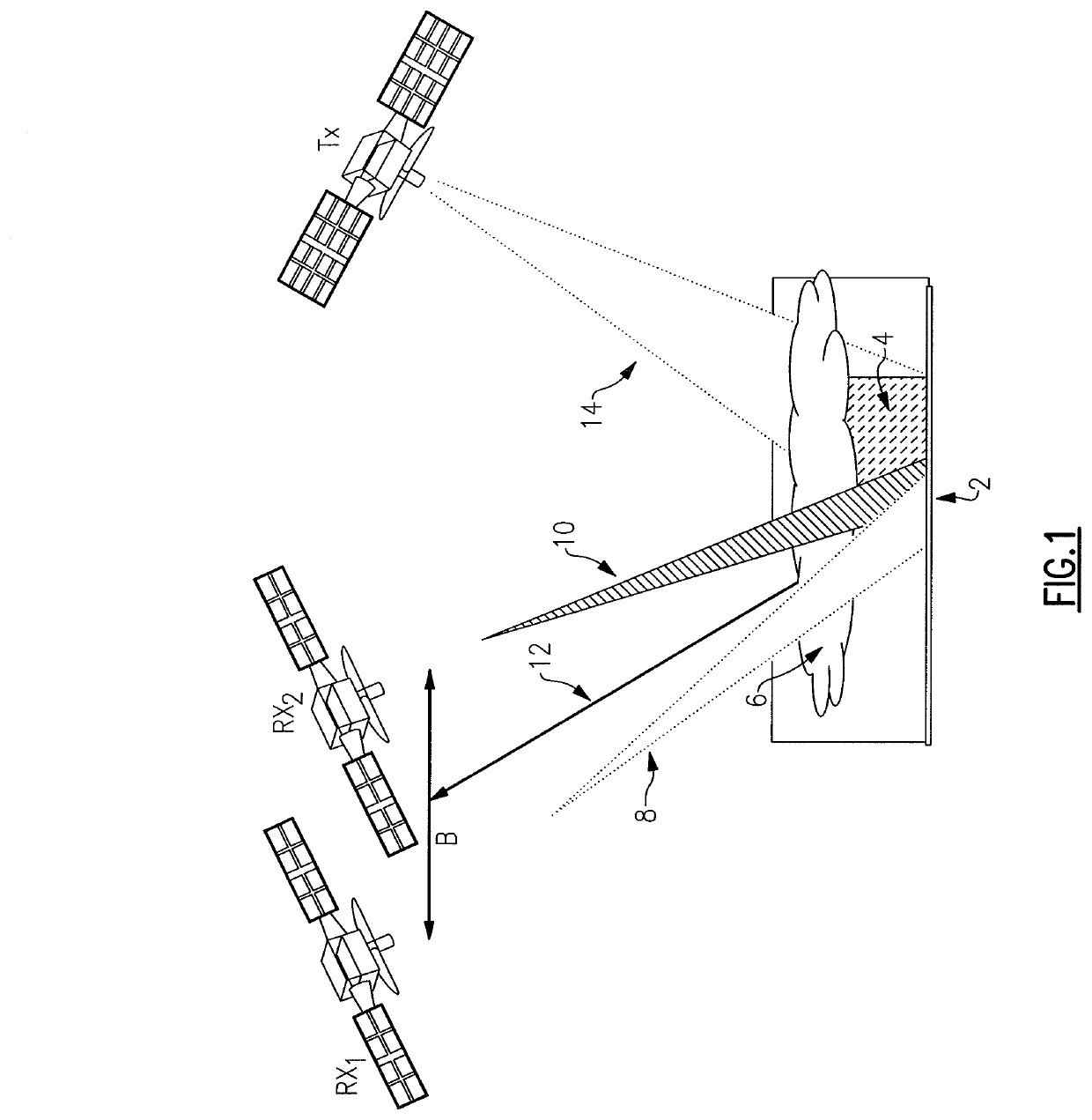
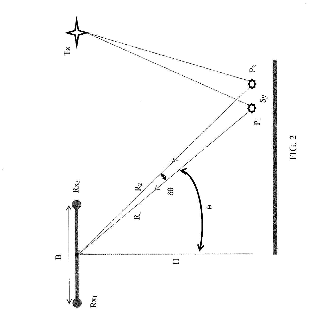
[0020]It has been recognized that the very large velocity difference between the observing platform and the observed precipitation field, when that observing platform is a spacecraft in low earth orbit, overcomes the echo decorrelation limitations previously encountered by researchers when attempting to observe the two dimensional (2D) precipitation fields using synthetic aperture RADAR from airborne platforms. Atlas, D. & Moore, R. K., 1987, “The Measurement of Precipitation with Synthetic Aperture Radar,” Journal of Atmospheric and Oceanic Technology, vol. 4, pp. 368-376. It is further recognized that multi-static synthetic aperture RADAR (SAR) observations of the precipitation fields which employ a plurality of receivers on different spacecraft at different cross-track orbital positions and which preserve phase difference information between the different receivers provides information on the cross-track precipitation field structure. When combined with the 2D SAR information gat...


PUM


Abstract

The system and method represents a high-resolution, three-dimensional, multi-static precipitation RADAR approach that employs agile microsatellites, in formation and remotely coupled, via a new high-precision, ultra-low power, remote timing synchronization technology. This system and method uses multi-static RADAR interferometric methods implemented via a microsatellite formation to synthesize an effectively large (e.g., 15 m) aperture to provide about 1 km horizontal resolution and about 125 m vertical resolution in the Ku-band.

Description

CROSS REFERENCE TO RELATED APPLICATIONS[0001]This application claims the benefit of U.S. Provisional Patent Application No. 62 / 519,283, filed Jun. 14, 2017, the content of which is incorporated by reference herein in its entirety.FIELD OF THE DISCLOSURE[0002]The present disclosure relates to satellite tomography of precipitation and motion and more particularly to the use of synthetic aperture RADAR and range-resolved long baseline interferometry methods with precision inter-satellite synchronization to provide a three dimensional map of the rain field of a storm at high spatial resolution from space.BACKGROUND OF THE DISCLOSURE[0003]Ground-based weather RADAR data are used more for weather monitoring rather than weather prediction. Specifically, these RADAR “see” where it is raining now. Sometimes, of course, where it is raining now may provide clues to where it will rain soon. Current systems show where it is raining, and most importantly, where a severe storm is present. Ground-b...

Claims


Application Information

Patent Timeline
IPC IPC(8): G01S13/95G01S13/90G01S13/00G01S13/87H04B7/195H04B7/185
CPCG01S13/878G01S13/9023G01S13/955G01S13/003H04B7/18576G01S13/9052H04B7/195G01S13/9058G01S7/40
Inventor MASCHHOFF, KEVIN R.RYBA, MARTIN F.
Owner BAE SYST INFORMATION & ELECTRONICS SYST INTERGRATION INC
Why Eureka
Try Eureka