InSAR and GNSS weighting method for three-dimensional surface deformation estimation

a three-dimensional surface deformation and weighting method technology, applied in the field of geodetic surveying, can solve the problems of difficult to accurately estimate the prior variance information of various observations, limited weighting accuracy thereof, and method is difficult to reflect influence, etc., to achieve accurate estimation, accurate insar/gnss weight ratio, accurate effect of weight ratio

Pending Publication Date: 2021-01-14
CENT SOUTH UNIV
View PDF1 Cites 14 Cited by
  • Summary
  • Abstract
  • Description
  • Claims
  • Application Information

AI Technical Summary

Benefits of technology

[0029]Compared with the prior art, the present invention has the following beneficial effects: the present invention provides the InSAR and GNSS weighting method for three-dimensional surface deformation estimation, which fuses InSAR and GNSS to estimate the three-dimensional surface deformation, wherein a functional relationship between InSAR / GNSS observations and the three-dimensional surface deformation of the unknown point is established based on the strain model. At the same time, the variance component estimation is used to accurately determine the weight ratio between the two types of observations of InSAR and GNSS. Finally, based on the least square method, the three-dimensional surface deformation is accurately estimated. Conventional methods require a large amount of time-series InSAR / GNSS data to provide redundant observations for weighting by variance component estimation, which is not suitable for instantaneous deformations (like volcanoes, earthquakes, etc.). The present invention uses the strain model to provide redundant observations in space, so that the variance component estimation can obtain accurate InSAR / GNSS weight ratio while lacking time-series data, thereby effectively improving accuracy and universality of three-dimensional surface deformation estimation with fused InSAR and GNSS.

Problems solved by technology

In fact, when detecting surface deformation, InSAR and GNSS are very susceptible to various uncertain factors, such as ionosphere, atmospheric water vapor, and surface vegetation coverage, which makes it difficult to accurately estimate the prior variance information of various observations.
However, InSAR observation errors are often different in space, so the weighting accuracy thereof is limited.
In addition, through the empirical formula of InSAR observation accuracy and coherence, the prior variance estimate of the observation can also be obtained, but such method is difficult to reflect the influence of the atmospheric long-wave error in the observation.

Method used


Image

  • InSAR and GNSS weighting method for three-dimensional surface deformation estimation
  • InSAR and GNSS weighting method for three-dimensional surface deformation estimation
  • InSAR and GNSS weighting method for three-dimensional surface deformation estimation

Examples


embodiment 1

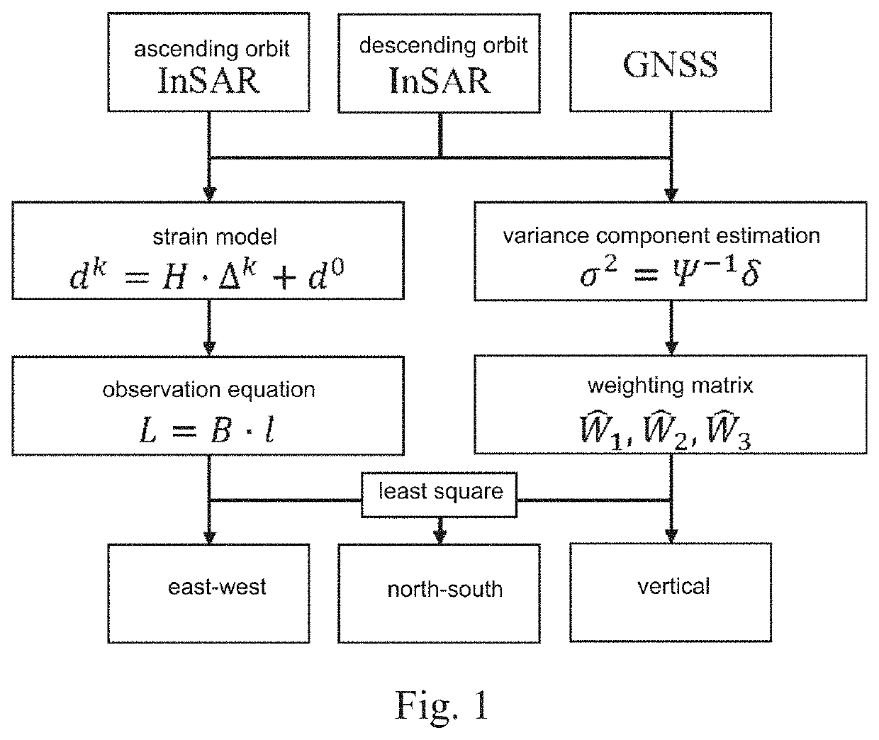
[0050]Referring to FIG. 1 the embodiment 1 is described as follows.

[0051]Step 1: establishing a functional relationship between three-dimensional deformation d0 of an unknown point and a certain amount of InSAR / GNSS data Li of surrounding points by using ascending and descending orbit InSAR data and GNSS data based on a strain model;

[0052]wherein how to determine a quantity of the InSAR / GNSS data used to establish the functional relationship will be described in step 2.

[0053]Assuming that a three-dimensional coordinate and a three-dimensional deformation of the unknown point P0 are x0=[xe0 xn0 xn0]T and d0=[de0 dn0 dn0]T, and a three-dimensional coordinate and a three-dimensional deformation of a surrounding point Pk are xk=[xek xnk xnk]T and dk=[dek dnk dnk]T, then a following equation can be obtained according to the strain model:

dk=H·Δk+d0  (1)

[0054]wherein Δk=xk−x0=[Δxek Δxnk Δxnk]T. H is an unknown parameter matrix of the stress-strain model, which can be expressed as:

H=[ξeeξen...

embodiment 2

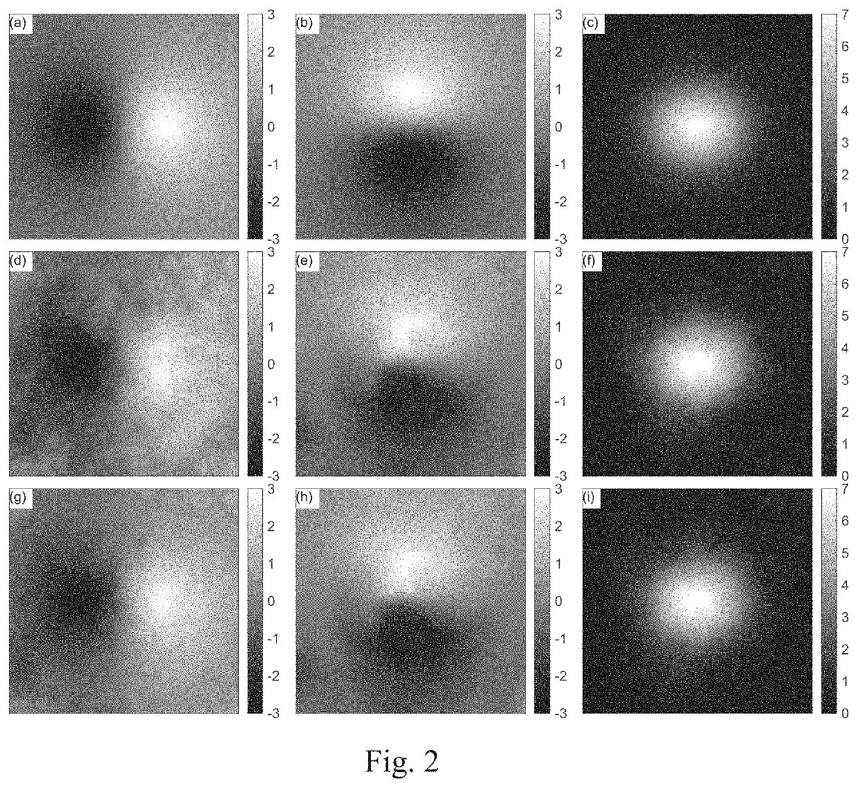
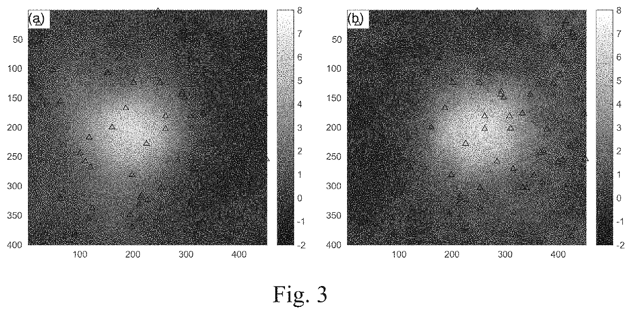
[0083]The embodiment 2 verifies the present invention through an experiment, as shown in FIG. 2-3. Referring to FIG. 2, (a)-(c) are the original simulated east-west, north-south and vertical deformation; (d)-(f) are east-west, north-south and vertical deformation data obtained by a conventional method: and (g)-(i) are east-west, north-south and vertical deformation data obtained by the method of the present invention (unit: cm). Referring to FIG. 3, (a) is the ascending orbit InSAR data, and (b) is the descending orbit InSAR data, wherein triangles in FIG. 3 represent location distribution of the GNSS sites (unit: cm).

[0084]Simulation data description: (1) simulating the three-dimensional deformation field in east-west, north-south and vertical directions in a certain area (image size 400×450) (as shown in FIG. 2, (a)-(c)); (2) combining imaging geometry of sentinel-1A / B satellite data to calculate the ascending and descending InSAR deformation results, wherein the incident angle an...


PUM


Abstract

An InSAR and GNSS weighting method for three-dimensional surface deformation estimation includes steps of: Step 1: establishing a functional relationship between three-dimensional deformation d0 of an unknown point and a certain amount of InSAR/GNSS data Li of surrounding points by using ascending and descending orbit InSAR data and GNSS data based on a strain model and observation imaging geometry: Step 2: performing relative weighting on Ki observation data in the InSAR/GNSS data Li, and determining an initial weight matrix Wi of various InSAR/GNSS observations; Step 3: determining accurate weight matrix Ŵi between the various InSAR/GNSS observations by variance component estimation, and solving the three-dimensional deformation d0 based on a least square method; and Step 4: performing the steps 1-3 for each surface point to estimate a high-accurate three-dimensional surface deformation field by fusing InSAR and GNSS.

Description

CROSS REFERENCE OF RELATED APPLICATION[0001]The application is a continuation application of a PCT application No. PCT / CN2020 / 091273, filed on May 20, 2020; and claims the priority of Chinese Patent Application No. CN 201910423735.8, filed to the State Intellectual Property Office of China (SIPO) on May 21, 2019, the entire content of which are incorporated hereby by reference.BACKGROUND OF THE PRESENT INVENTIONField of Invention[0002]The present invention relates to a technical field of geodetic surveying with remote sensing images, and more particularly to an InSAR and GNSS weighting method for three-dimensional surface deformation estimation.DESCRIPTION OF RELATED ARTS[0003]Interferometric Synthetic Aperture Radar (SAR, InSAR) and Global Navigation Satellite System (GNSS) have been widely used to detecting surface deformation caused by earthquakes, volcanoes, underground mining, etc. InSAR technology processes two SAR images of the same area at different times (with an interval r...

Claims


Application Information

Patent Timeline
Patent Type & Authority Applications(United States)
IPC IPC(8): G01S13/90G01S19/43G01S19/14G06F17/16
CPCG01S13/9023G06F17/16G01S19/14G01S19/43G01S13/90G01B15/06G01S19/48G01S19/485
Inventor HU, JUNLIU, JIHONGLI, ZHIWEIZHU, JIANJUN
Owner CENT SOUTH UNIV
Why Eureka
Try Eureka