Spatial autocorrelation machine learning-based downscaling method and system of satellite precipitation data

Active Publication Date: 2022-02-10
GUANGZHOU INST OF GEOGRAPHY GUANGDONG ACAD OF SCI +1
View PDF0 Cites 5 Cited by
  • Summary
  • Abstract
  • Description
  • Claims
  • Application Information

AI Technical Summary

Benefits of technology

[0075]The spatial autocorrelation machine learning-based downscaling method of satellite precipitation data, system and terminal can find the spatial autocorrelation characteristic of the precipitation data well via the geo-statistics of spatial autocorrelation analysis, and can carry out a more accurate precipitation prediction of a complex area by a

Problems solved by technology

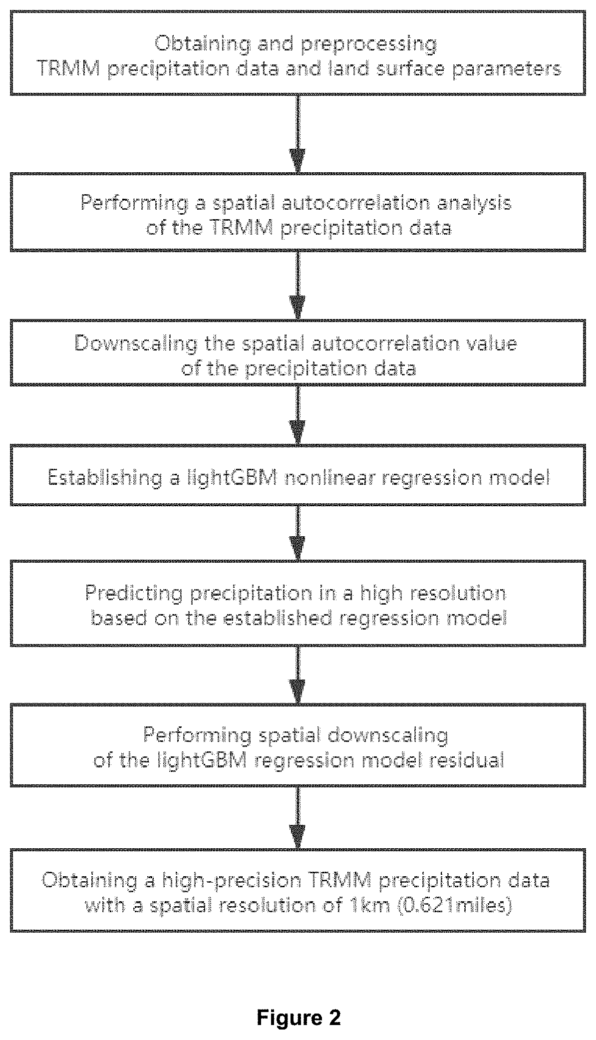
However, due to the low original resolution of satellite remote sensing (the spatial resolution is generally 0.25°, about 25 km (15.534 miles)), it is difficult to reflect the spatial details of a regional precipitation.
In addition, due to the limitations of the physical principle and algorithm of satellite retrieval precipitation, there are certain limitations and deviations in terms of regional scale precipitation, so it is necessary to carry out a spatial downscaling for satellite remote sensing precipitation data, so as to obtain high-precision and high-resolution precipitation data (about 1 km (0.621 miles)).
However, there are still two shortages.
On the one hand, the established regression model between precipitation and land surface parameters does not consider the spatial autocorrelation information of precipitation, which will cause a loss of spatial information of precipitation data and bring uncertainty to the model establishment.
On the other hand, only traditional point interpolation methods like spline interpolation or others are used for residuals correction, without considering the difference of area element scale before and after downscaling and the intrinsic spatial relativity of data, which will bring certain precision loss to downscaling results.
However, this method still has the following problems:
(2) This method only adopts the traditional interpolation method to correct the precipitation residual, and it does not consider the difference of the surface element scale before and after the downscaling and the intrinsic spatial correlation of the data, which will bring certa

Method used


Image

  • Spatial autocorrelation machine learning-based downscaling method and system of satellite precipitation data
  • Spatial autocorrelation machine learning-based downscaling method and system of satellite precipitation data

Examples


Embodiment Construction

[0080]The embodiments of the invention are described in detail as following. The embodiments of the invention are implemented on the premise of the technical scheme of the invention, and the detailed embodiments and the specific operation process are given. It should be pointed out that a person skilled in the art can make several deformations and improvements without breaking away from the idea of the present invention, which belong to the protection scope of the present invention.

[0081]The embodiment of the present invention provides a machine learning downscaling method for satellite remote sensing precipitation data considering spatial autocorrelation. The method firstly performs a spatial autocorrelation analysis of a TRMM monthly precipitation data of 25 km (15.534 miles) to calculate a spatial autocorrelation values and obtain a spatial autocorrelation values of the precipitation data of 1 km (0.621 miles) by using an area to point Kriging interpolation method to interpolate;...


PUM


Abstract

A spatial autocorrelation machine learning-based downscaling method of satellite precipitation data includes obtaining the TRMM precipitation data and the land surface parameters; preprocessing the land surface parameters to obtain DEM, day land surface temperature, night surface land temperature, day-and-night land surface temperature difference and NDVI with spatial resolutions of 1 km (0.621 miles) and 25 km (15.534 miles); performing a spatial autocorrelation analysis of the TRMM precipitation data to obtain an estimated spatial autocorrelation value of the precipitation data with a spatial resolution of 25 km (15.534 miles); downscaling the spatial resolution of the spatial autocorrelation value of the precipitation data from 25 km (15.534 miles) to 1 km (0.621 miles); establishing a nonlinear regression model; obtaining a precipitation downscaling data with a spatial resolution of 1 km (0.621 miles) based on the nonlinear regression model. A system and a terminal are also provided.

Description

[0001]This application claims priority of the Chinese Patent Application No. 201910971041.8, entitled “A Spatial Autocorrelation Machine Learning-based Downscaling Method and System of Satellite Precipitation Data” filed on Oct. 14, 2019, the entire content of which is hereby incorporated by reference.TECHNICAL FIELD[0002]The invention relates to a downscaling method for satellite remote sensing precipitation data and, in particular, to a machine learning satellite precipitation data downscaling method, system and terminal considering spatial autocorrelation.BACKGROUND[0003]Precipitation is a key parameter reflecting land surface environmental conditions and global water cycle, which is an important component of water cycle and energy exchange in the climate system, and an important indicator representing climate change. Extreme weather and climate events of precipitation (flood and drought) have an important impact on human production and living. High spatial and temporal resolutio...

Claims


Application Information

Patent Timeline
IPC IPC(8): G01W1/14G06T3/40G01W1/10G06N7/00G06N20/00G06F17/18
CPCG01W1/14G06T3/4007G06F17/18G06N7/00G06N20/00G01W1/10G06F18/213G06F17/17G06T3/4053G06N7/08
Inventor XU, JIANHUIRUAN, HUIHUAYANG, JIHU, HONGDAZHONG, KAIWENZHOU, CHENGHU
Owner GUANGZHOU INST OF GEOGRAPHY GUANGDONG ACAD OF SCI
Why Eureka
Try Eureka