Error and integrity evaluation via motion prediction

Pending Publication Date: 2022-08-04
CONTINENTAL TEVES AG & CO OHG
View PDF0 Cites 0 Cited by
  • Summary
  • Abstract
  • Description
  • Claims
  • Application Information

AI Technical Summary

Problems solved by technology

Multiplying this by the speed of light produces the spacing between the two, which is, admittedly, very inaccurate due to the lack of synchronization of the clocks of the satellite and receiver.
Due to the

Method used


Image

  • Error and integrity evaluation via motion prediction

Examples


Embodiment Construction

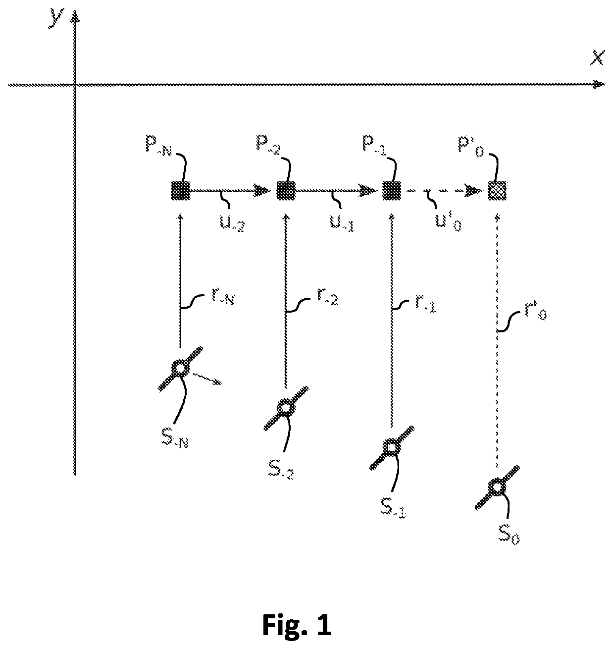
[0040]FIG. 1 shows a schematic representation of a two-dimensional, exemplary representation of the motion of a receiver and a satellite, stretched along the spatial axes X, Y, as well as their spacings at determined times, wherein the receiver is contained in a vehicle, the motion of which is equated with that of the receiver. The reference numerals each contain a time index i, wherein the scanning time is denoted by i. −N, −2 and −1 accordingly denote times in the past, at which measurements were performed. By way of contrast, a later time corresponds to the present and is denoted by i=0. The satellite shown is representative of any satellite and takes up the positions S−N, S−2, S−1, S0 at the various times i.

[0041]The position values correspond to the receiver position, wherein P is described by P−N, P−2, P−1. They are obtained via time-discrete runtime measurements by means of a satellite navigation system, for example NAVSTAR GPS, Galileo, GLONASS or Beidou. The vectors u−1, u−...


PUM


Abstract

Error and integrity evaluation during a position determination, includes: recording position values (P−N, P−2, P−1) and calculating clock errors of a receiver via time-discrete runtime measurements by a satellite navigation system; recording a first pseudo-distance at a later time via time-discrete runtime measurement by the satellite navigation system; extrapolating a position value (P′0) of the receiver at the later time and extrapolating a clock error of the receiver at the later time; establishing a distance (r′0) between the extrapolated position value (P′0) of the receiver and the position of a satellite (S0) of the satellite navigation system at the later time, wherein a quality measure for the usability of the position determination with the satellite is obtained by forming a second pseudo-distance based on the sum of the established distance (r′0) and the extrapolated clock error at the later time and comparing the second pseudo-distance with the first pseudo-distance.

Description

BACKGROUND[0001]The invention relates to a method for error and integrity evaluation during a position determination as well as a control device and a computer program product for performing the method.[0002]Nowadays, the absolute geoposition of a vehicle can be determined with the aid of receivers for global satellite navigation systems (GNSS), hereinafter also referred to as GNSS measurement. In addition, the relative motion of a vehicle can be determined, for example with the aid of inertial (IMU) and odometry (ODO) sensor technology installed in the vehicle.[0003]Firstly, the GNSS system makes it possible to measure the receiver position via runtime measurements, also known as code ranging. Secondly, it makes it possible to measure the receiver speed via Doppler shifts.[0004]Within the framework of sensor fusion, GNSS, IMU and ODO measurements can be fused in order to obtain more precise and more readily available position determinations. The sensor fusion is usually realized wi...

Claims


Application Information

Patent Timeline
IPC IPC(8): G01S19/20G01S19/45
CPCG01S19/20G01S19/45G01S19/22G01S19/23G01S19/396G01S19/47
Inventor KUBINA, BERNDBURGHARDT, ROLANDBODENHEIMER, ROBERT
Owner CONTINENTAL TEVES AG & CO OHG
Why Eureka
Try Eureka