Navigational system and method utilizing sources of pulsed celestial radiation

a technology of pulsed celestial radiation and navigation system, which is applied in the direction of optical radiation measurement, comonautical navigation instruments, instruments, etc., can solve the problems of only being accurate to a finite angular accuracy, affecting the trajectory of the vehicle, and increasing the error in navigational data

Active Publication Date: 2007-03-27
UNIV OF MARYLAND
View PDF15 Cites 41 Cited by
  • Summary
  • Abstract
  • Description
  • Claims
  • Application Information

AI Technical Summary

Benefits of technology

[0021]The present invention provides for a system and method for navigation utilizing sources of pulsed celestial radiation. The system includes a mobile receiver for detecting signals of pulsed celestial radiation. The mobile receiver is in communication with a clock or timer for generating a timing signal corresponding to the reception of the pulses. A processing means calculates a time offset between predicted and measured time of reception of the pulsed celestial signal with respect to a chosen inertial reference frame. The processing means is further in communication with a digital memory system that stores positional data of known sources of pulsed celestial radiation. Using the position data along with the calculated time offset, the processing means can calculate navigational data for the spacecraft, satellite, planetary rover, or other vehicle upon which the mobile receiver is mounted.

Problems solved by technology

Although this system requires no active hardware on the spacecraft itself, it does require an extensive ground tracking system and careful analysis of the measured data against an electromagnetically noisy background environment.
However, vehicle maneuvers or any unaccounted for disturbances will affect the trajectory of the vehicle.
As the spacecraft moves further away from Earth observation stations, the error in navigational data increases.
However, even with this precise knowledge, the position measurement can only be accurate to a finite angular accuracy.
As the vehicle gets more distant, any fixed angular uncertainty reduces the knowledge of vehicle position, especially in the two transverse axes relative to the range direction.
Even utilizing interferometry, using the difference between multiple signals compared at two ranging stations, the angular uncertainty rapidly grows above acceptable limits.
Although improvements in the range measurement are made utilizing such system, transverse axis errors still exist, and this method has errors that also grow with distance.
Real-time measurements using such systems are typically not easily achieved.
Additionally, optical measurements are limited by favorable weather and environmental conditions.
However, due to the large number of visible stars, detecting specific stars can be time-consuming due to necessary almanac database searches.
Also, since there is no method of determining “when” the visible light was sent from the stars and because the stars are located so far away, determining range information from an individual star to help “triangulate” a spacecraft's position is problematic.
However, both the radio and optical signatures from pulsars have limitations that reduce their effectiveness for spacecraft missions.
This is not attractive for vehicle design.
At the radio frequencies which pulsars emit (˜100 MHz—few GHz) and with their faint emission, large antennae (likely 25 m in diameter or larger) would be required, which would be impractical for most spacecraft.

Method used


Image

  • Navigational system and method utilizing sources of pulsed celestial radiation
  • Navigational system and method utilizing sources of pulsed celestial radiation
  • Navigational system and method utilizing sources of pulsed celestial radiation

Examples


Embodiment Construction

I. Overview

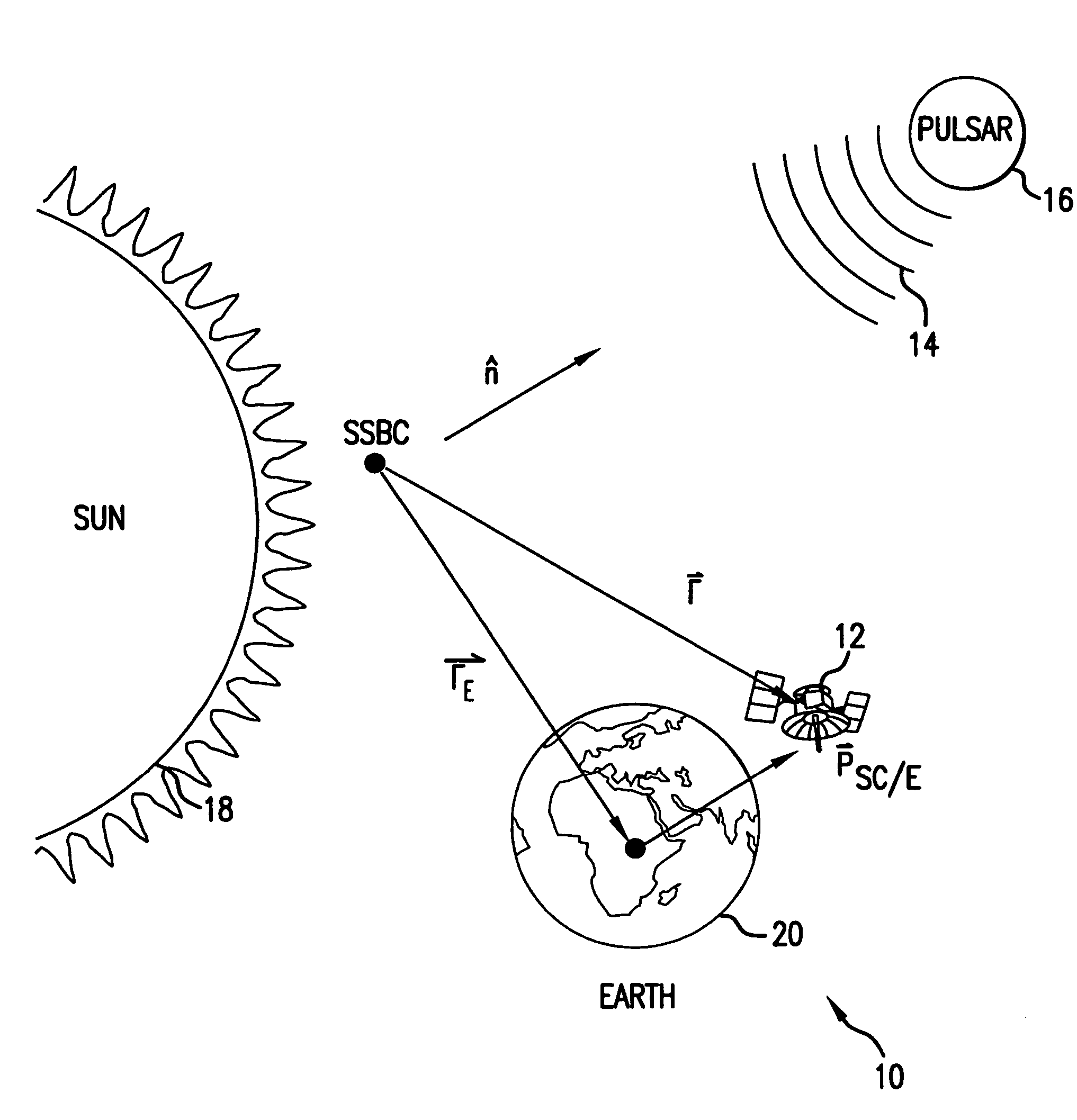
[0040]Referring now to FIG. 1, there is shown a navigational system 10 for calculating position data of a satellite 12 or other displaceable receiving platform based upon a signal 14 generated by a celestial body 16. Although shown in FIG. 1 as a pulsar, the celestial body 16 can be any celestial body or source of a pulsed electromagnetic signal.

II. Pulsed Celestial Sources

[0041]Although Earth-based navigational systems, such as the Global Positioning System (GPS) provide navigational data including time, latitude, longitude, altitude, and attitude of a body on Earth, such systems have a limited scope of operations for vehicles moving and operating relatively far from the planet Earth. The system 10, however, utilizes celestial sources, such as pulsars, to provide a stable, predictable and unique signature signal in order to operate and navigate beyond the influence of the planet Earth.

[0042]Pulsars were initially discovered by Hewish, et al. in 1968 during a sky survey o...


PUM


Abstract

A system and method for navigation utilizing sources of pulsed celestial radiation are provided. A spacecraft, satellite, or other vehicle (12) has a pulse sensor (22) mounted thereto for detecting signal pulses (14) generated by a plurality of pulsars or other celestial objects (16). The detected signal pulses (14) are synchronously averaged at the known period of the pulsar or other celestial object (16) with respect to a timer (24). Timer (24) measures the pulse time of arrival at the pulse sensor (22) by comparing the pulse signal (14) with a pulse shape template (52), and a processing means (30) calculates the offset time between the measured pulse time of arrival at sensor (22) with a calculated pulse time of arrival at the solar system barycenter (SSBC). The positions and pulse profile characteristics of the pulsars (16) are stored in a digital memory (34) and combining the calculated time offset with the known positions of pulsars (16), the navigational position, velocity, attitude and time of spacecraft (12) with respect to the SSBC can be calculated.

Description

BACKGROUND OF THE INVENTION[0001]1. Field of the Invention[0002]The subject invention relates to a system and method for navigation utilizing sources of pulsed celestial radiation. In particular, the present invention directs itself to a mobile receiver for detecting pulsed signals generated by celestial sources of pulsed radiation. The mobile receiver is mounted on a spacecraft, satellite, planetary rover, or other vehicle and the received pulses are used for the calculation of navigational data for the vehicle. More particularly, this invention directs itself to a clock or timer in communication with the mobile receiver for generating a timing signal corresponding to the reception and detection of the pulsed celestial radiation. The timing signal is used to calculate a time offset between predicted and measured pulse reception at the mobile receiver. Incorporating predetermined models of the pulse arrival times within an inertial reference frame, a position offset of the mobile re...

Claims


Application Information

Patent Timeline
Patent Type & Authority Patents(United States)
IPC IPC(8): G06F7/00G06F17/00B64G1/36
CPCB64G1/36
Inventor SHEIKH, SUNEEL ISMAILPINES, DARRYLL JOHNWOOD, KENT S.RAY, PAUL SHELTONLOVELLETTE, MICHAEL N.
Owner UNIV OF MARYLAND
Why Eureka
Try Eureka