System and method for a safe depiction of terrain, airport and other dimensional data on a perspective flight display with limited bandwidth of data presentation

a technology of data presentation and data, applied in the field of real-time depiction of terrain and other dimensional data on a perspective flight display, can solve the problems of not being able to generate error bounds, the lod method may not achieve the optimal polygon reduction, and the inability to depict such a scene in real time with a large amount of terrain data, etc., and achieve the effect of limited data presentation bandwidth

Active Publication Date: 2007-08-28
ROCKWELL COLLINS INC
View PDF13 Cites 39 Cited by
  • Summary
  • Abstract
  • Description
  • Claims
  • Application Information

AI Technical Summary

Benefits of technology

[0007]Accordingly, the present invention provides a method and system for safe depiction of global space data including terrain, airport, and other dimensional data on a perspective flight display with limited bandwidth of data presentation. Further, the method and system of the present invention allows a user to attain an amount of geometry information to be displayed based on a visual error threshold selected by the user. Therefore, the user may determine the scale of the application depending on capacities of hardware platforms.
[0009]The terrain application system may utilize various viewer-dependent Level of Detail rendering (LOD) methods. The terrain application system may dynamically generate terrain meshes for each frame based on error bounds. Accordingly, the terrain application system may provide the optimal detail and triangle ratio due to reduced use of triangles within a given error threshold. By utilizing the terrain application system to do a breadth-first search on the terrain database, the user can attain a deterministic amount of geometry and therefore may determine a desirable scale of geometric detail tune to a given hardware platform. For example, given a system that operates at 1,000 triangles per scene, the system can fill that budget while optimizing / minimizing the visual error over the scene. The user may have a choice of level of detail terrain rendering by changing the level of error threshold. The error metric, in addition to being distance-based, can also be center-of-screen or a given position-based.
[0010]The present invention may provide more detailed terrain rendering for areas where the user desired detailed views. In another advantageous aspect of the present invention, the user may have a prior knowledge of the degradation in performance for a low powered platform. It also allows trade off between frame rates and visual error. Further, the terrain application system may be suitable to utilize various existing distance dependent LOD methods.

Problems solved by technology

Consequently, depiction of such a scene in real time with a large amount of terrain data often exceeds capacities of currently available systems.
As such, the LOD method may not achieve the optimal polygon reduction since the level of detail does not take actual elevation data into account.
Moreover, it is impossible to generate error bounds (an error bound is an approximate error of each polygon representation) correctly since some data is discarded based on a viewpoint only.
However the method requires preprocessing of terrain data for runtime optimizations.
Furthermore, its approach is usually based on a geometric error, which does not take the position of a viewer into account.
The visibility preprocessing method may not differentiate a significant terrain area from a non-significant terrain area.

Method used


Image

  • System and method for a safe depiction of terrain, airport and other dimensional data on a perspective flight display with limited bandwidth of data presentation
  • System and method for a safe depiction of terrain, airport and other dimensional data on a perspective flight display with limited bandwidth of data presentation
  • System and method for a safe depiction of terrain, airport and other dimensional data on a perspective flight display with limited bandwidth of data presentation

Examples


Embodiment Construction

[0023]Reference will now be made in detail to the presently preferred embodiments of the invention, examples of which are illustrated in the accompanying drawings.

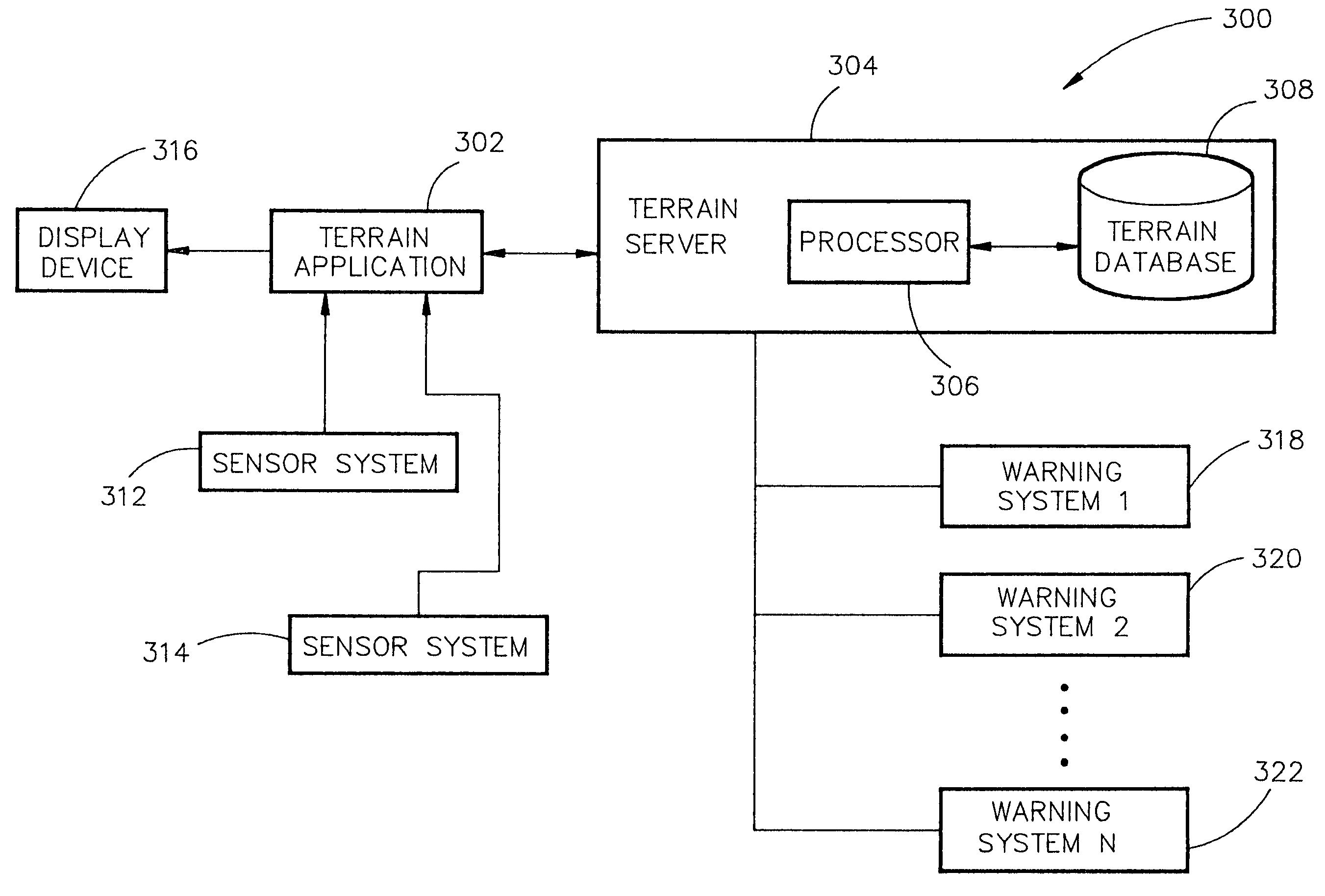
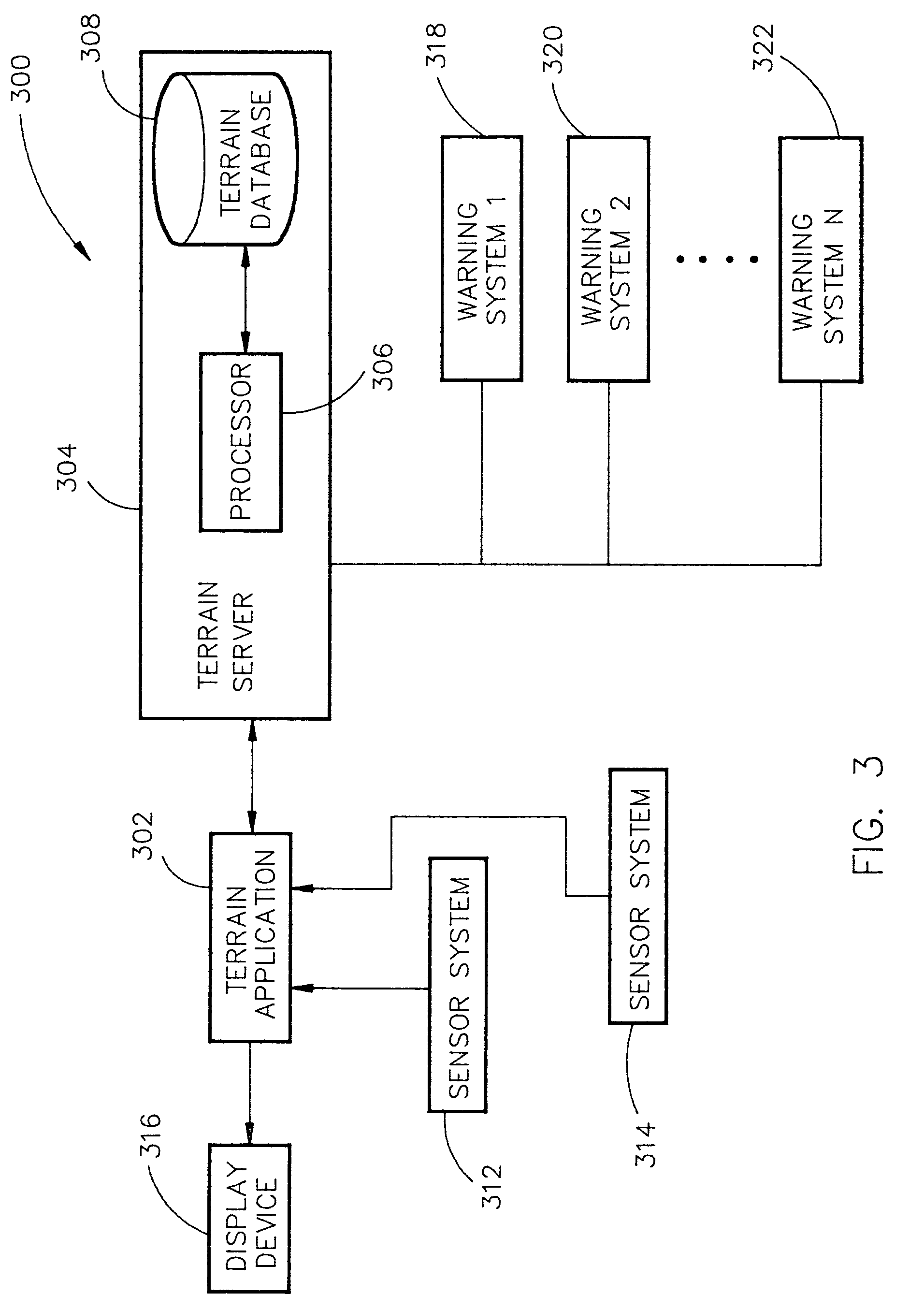
[0024]Referring generally now to FIGS. 3 through 9B, exemplary embodiments of the present invention are shown.

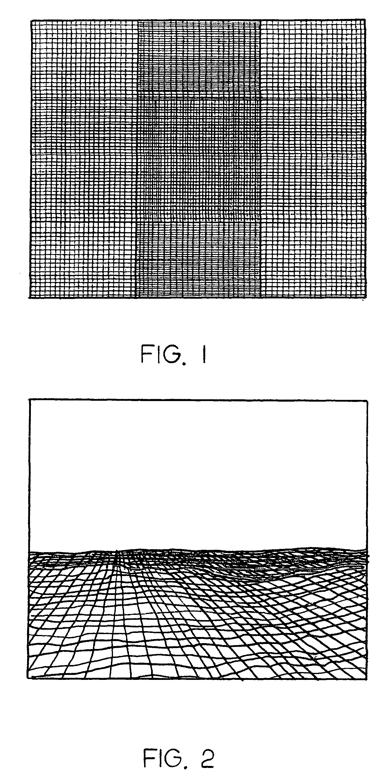
[0025]The present invention is directed to a system and method for a safe flight display through increasing situation awareness by an optimal presentation, given limited capacity of the system. The system may determine which terrain area needs a detail representation and which area needs a coarse representation. A view-dependent visual error metric may be utilized to define and maintain an error bound and accurately minimize the amount of terrain data being depicted. The base unit for visual error is the unit of visual depiction and on theses displays a pixel. This can be translated into world units of meters. The system guarantees optimal use of triangles (terrain grids) within a given error bound and thus the sys...


PUM


Abstract

The present invention is directed to a system and method for a safe flight display through increasing situation awareness by an optimal presentation, given limited capacity of the system. The system may determine which terrain area needs a detail representation and which area needs a coarse representation. A view-dependent visual error metric may be utilized to define and maintain an error bound and accurately minimize the amount of terrain data being depicted. By performing a breadth-first search on the terrain database, a user can determine amount of geometry to be displayed with limited bandwidth of data presentation. The user may be allowed to scale the application to his / her desired level of detail, given a capacity of the system. Therefore, the system may provide a safe flight display with an anticipated and graceful (all portions of the screen would be given an equal quality representation) degradation in performance upon the choice of the user.

Description

FIELD OF THE INVENTION[0001]The present invention generally relates to the field of depiction of dimensional data and particularly to a real time depiction of terrain and other dimensional data on a perspective flight display.BACKGROUND OF THE INVENTION[0002]With the rapid development of technology in scene visualization and computer graphics, there are various ways to display digital terrain images in real time referenced relative to the travel of an aircraft over a terrain. Flight displays require depiction of large terrain areas. Further, each scene (of a terrain) may contain millions of polygons in order to provide a safe flight display with high fidelity digital terrain depictions. Consequently, depiction of such a scene in real time with a large amount of terrain data often exceeds capacities of currently available systems.[0003]Various methods for reducing resolution have been utilized in order to reduce the amount of terrain data for a particular depiction of data within the...

Claims


Application Information

Patent Timeline
Patent Type & Authority Patents(United States)
IPC IPC(8): G08B23/00
CPCG01C23/00G06T17/05G06T17/20G08G5/0021G08G5/0086G06T2210/36Y10S707/99945Y10S707/99948
Inventor VOGL, THOMAS L.ANDERSON, ERIC N.POSTNIKOV, ALEXELKATAKURA, KOJI
Owner ROCKWELL COLLINS INC
Why Eureka
Try Eureka