
Method of processing positioning signals, in particular for indoor applications

a positioning signal and indoor application technology, applied in surveying, navigation, instruments, etc., can solve the problems of inability to demodulate navigation messages, high attenuation and blockage, and conventional gnss signal processing and positioning algorithms fail, so as to achieve efficient and accurate estimation of code delays

Active Publication Date: 2011-11-15
EUROPEAN SPACE AGENCY
View PDF17 Cites 29 Cited by
  • Summary
  • Abstract
  • Description
  • Claims
  • Application Information

AI Technical Summary

Benefits of technology

[0023]An object of the present invention is to provide a method of processing a snapshot of a positioning signal allowing an efficient and accurate estimation of the code delay of code-modulated signals even in indoor environments, overcoming at the same time at least part of drawbacks and limitations of the prior art.
[0024]This object is achieved by the method of the invention, offering the following advantages:
[0027]it is not necessary to acquire all “strong” satellite emitters before any weak satellite can be acquired: the near-far problem detector does not have to wait for the acquisition of all satellite emitters; and
[0029]In particular, a preferred embodiment comprises a near-far problem mitigation step which is not applied on all satellite emitters, but only on those that have been classified as near-far interfered by the near-far problem detector, thus considerably reducing the computational complexity.

Problems solved by technology

In some occasions, it is not possible to demodulate the navigation message, either due to low level of the received signal or due to time constraints in the time to first fix (note that it would be required to obtain the information in the navigation message of each satellite emitter during a time interval up to thirty seconds).
Conventional GNSS signal processing and positioning algorithms fail when the receiver is located in highly-dense urban areas, such as urban canyons, or inside buildings.
In both types of environments, GNSS signals are subject to high attenuation and blockage (due to propagation through buildings and so-called “urban canyons”), the so-called “near-far problem” (since signals coming from different satellite emitters experiment very different attenuation), and severe multipath due to signal reflection and diffraction [Lachapelle, 2004b].
The fact that signals from different satellite emitters can experiment different attenuation as they follow different propagation paths gives rise to the so-called near-far problem: if two signals, coming from different transmitters, reach the receiver with a big difference in power, the code delay estimation of the weakest signal will present important errors due to the interference of the strongest one.
In these systems, the power differences are due to the differences in distance from the mobile to the base stations; however, in GNSS the power differences are caused by the different attenuation of the propagation paths, and not by the differences in distance from the receiving unit to the satellites, which are relatively small.
Near-far problem will not only affect the code delay estimate, but also the estimation of other parameters of the weakest signals, such as the frequency and the data (in case that it is possible to estimate the data).
The error in the code delay can be very important and gives rise to high positioning errors.
In an extreme case, the weakest signal could not even be detected by the receiving unit.
This problem also happens outdoors, where there is a line-of-sight signal (also called direct-ray signal), which is the one to be used in the pseudorange estimation, and other delayed replicas of the signal with smaller amplitude that are originated by reflection and / or diffraction on obstacles around the receiver.
The delayed replicas cause an additional error in the code delay estimation of the desired signal, which is the line-of-sight signal, if it exists, or otherwise the signal with the shortest propagation path.
This error is ultimately due to the fact that the receiver cannot distinguish the desired signal from the rest when their relative delays are small compared to the inverse of the signal bandwidth.
Given the above-referred problems, conventional GNSS receivers, designed for outdoor applications, are not able to work properly indoors since they fail in accurately estimating the code delay of the signal generated by the individual satellite emitters.
Lack of an accurate estimation of the code delay forbids accurate positioning of the receiver unit.
Some of the difficulties associated with indoor positioning are well known, and several solutions have been proposed in the past, none of which gives complete satisfaction.
Nevertheless, the main problem of those approaches is the use of tracking, since it makes the receiver work continuously.
This is a major problem concerning power consumption because these kinds of receivers are intended to be mounted on a mobile platform, like a mobile phone.
However, it raises the problem of the poor estimation of the code delay in the acquisition stage.
The drawback of those embodiments is that they work properly only when i) the code period is a multiple of the sampling period and ii) for moderately-long dwell times, i.e. on the order of 1 second or less.
If i) is not complied, the FFT-based acquisition leads to an error in the code delay estimation, despite the use of interpolation.
Due to technical constraints, it is not always possible to select a sampling frequency fulfilling the former condition.
Regarding long dwell times, i.e. larger than 1 second, even small differences between the trial Doppler frequencies and the real one can lead to a degradation in the correlation computation due to the Doppler effect in the code and, subsequently, to an error in the code delay estimation.
However, in order to obtain an integer number of samples per code period, re-sampling of the incoming signal is performed at the expense of increasing the receiver complexity.
Nevertheless, the problem of long dwell times is neither dealt with nor solved.
A main problem with the previous methods is that they require that either all the satellite emitters or at least the strong ones (the ones received with higher power level, which are likely to produce interferences) have been acquired before running the near-far problem detection and / or mitigation algorithm.
This increases the processing time.
Further, a reduced delay-Doppler space after the first satellite emitter acquisition cannot be performed since it is not assured that this first satellite emitter is unaffected by the near-far problem.

Method used


Image

  • Method of processing positioning signals, in particular for indoor applications
  • Method of processing positioning signals, in particular for indoor applications
  • Method of processing positioning signals, in particular for indoor applications

Examples


first embodiment

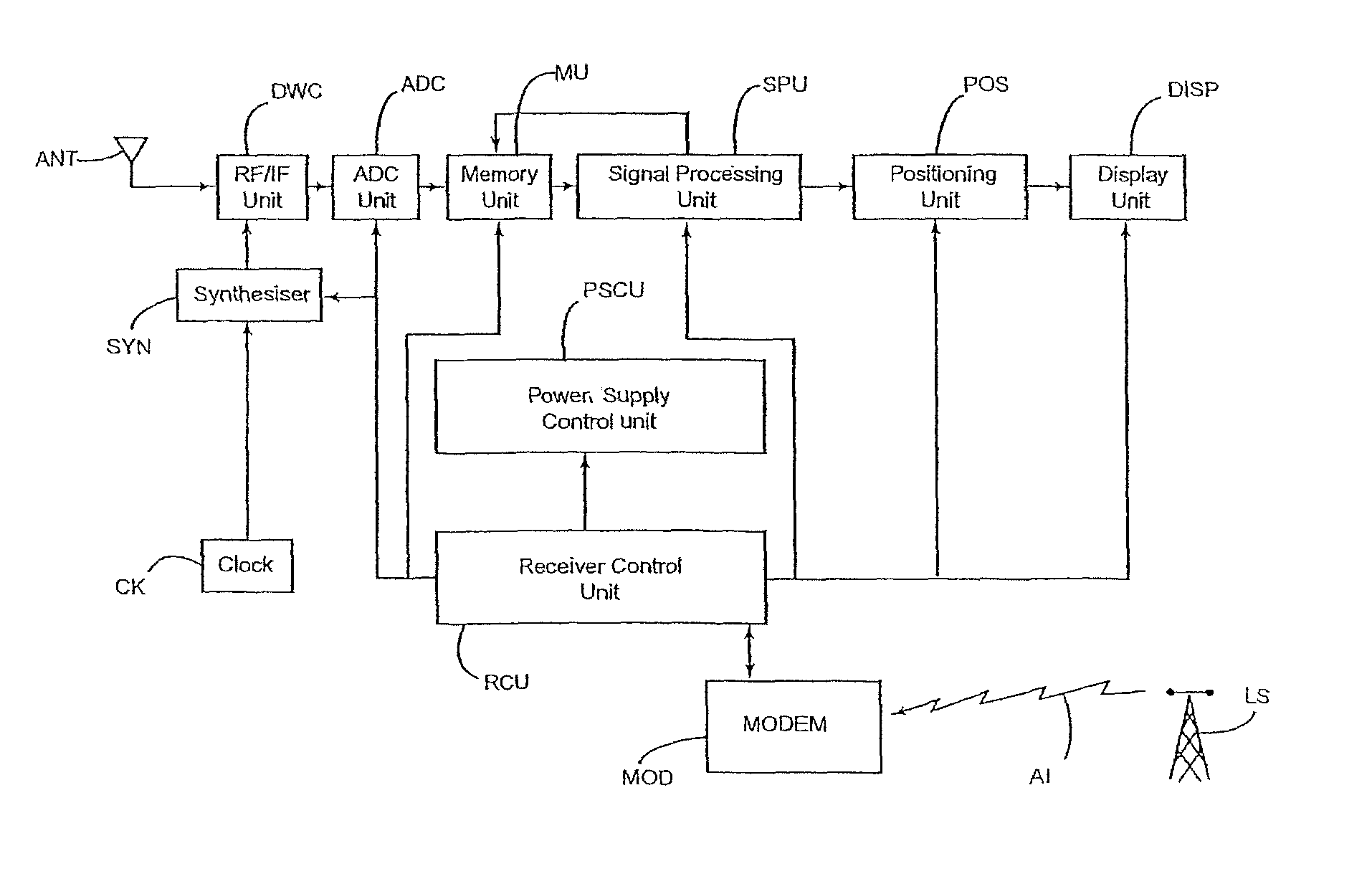
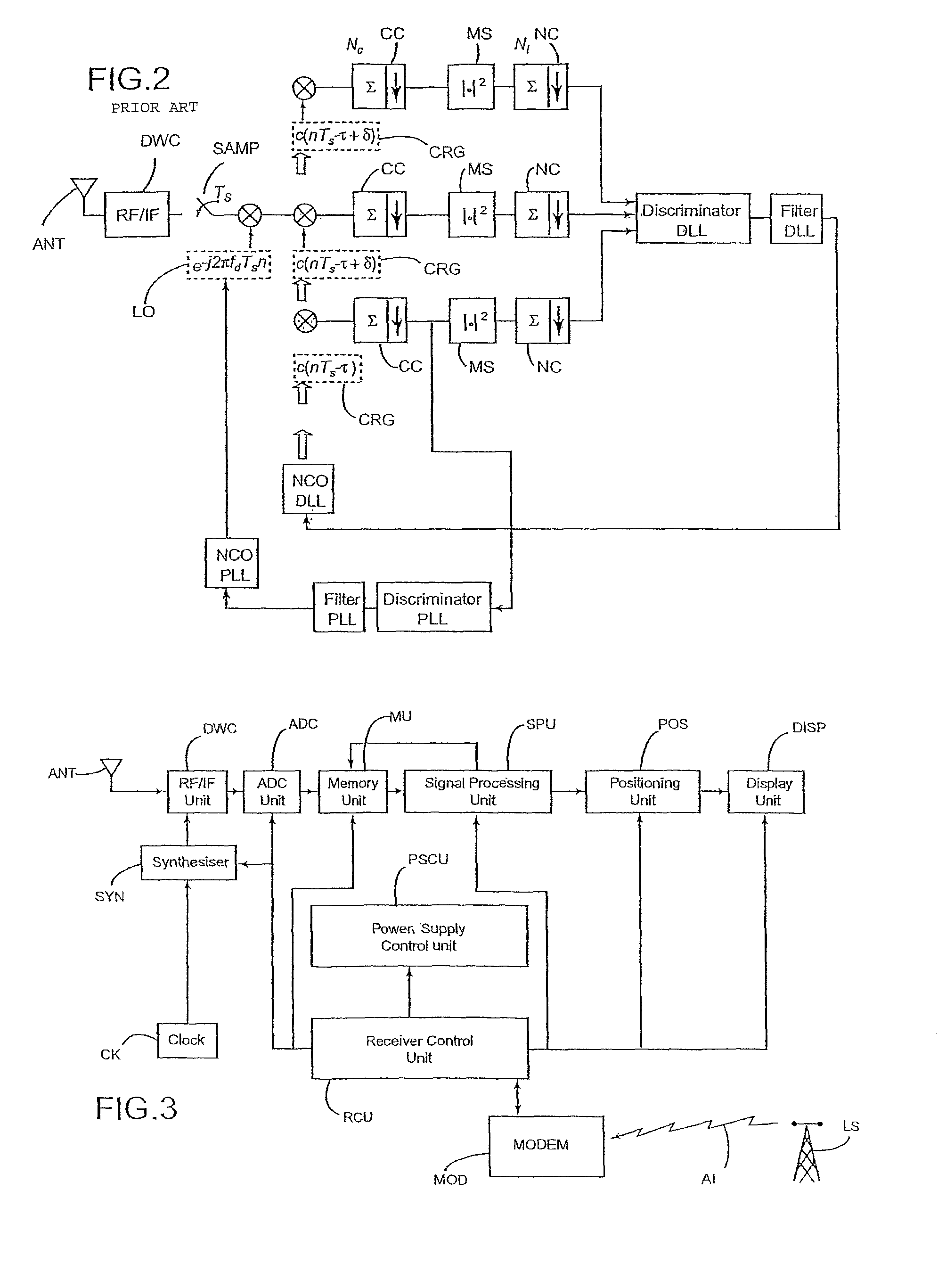
[0064]this processing method is schematically represented by the flow-chart of FIG. 4. In this embodiment, the Signal Processing Units stores a list of all the satellite emitters in view from the present location, the identification of their modulating codes and their approximate carrier frequency shift (subsequently referred to as “Doppler frequency” even if, as already pointed out, it is not only due to Doppler effect). This information is obtained from the assistance data and passed to the Signal Processing unit through the Receiver Control unit. Assistance data are extremely helpful in simplifying the subsequent signal processing, as only the modulating codes of in-view satellite emitters and frequency shifts in a limited range around the approximate Doppler frequencies need to be searched for. However, the method of the invention can also apply to autonomous positioning (without assistance data): in this case, the “list of in-view satellite emitters” comprises all the emitters ...

third embodiment

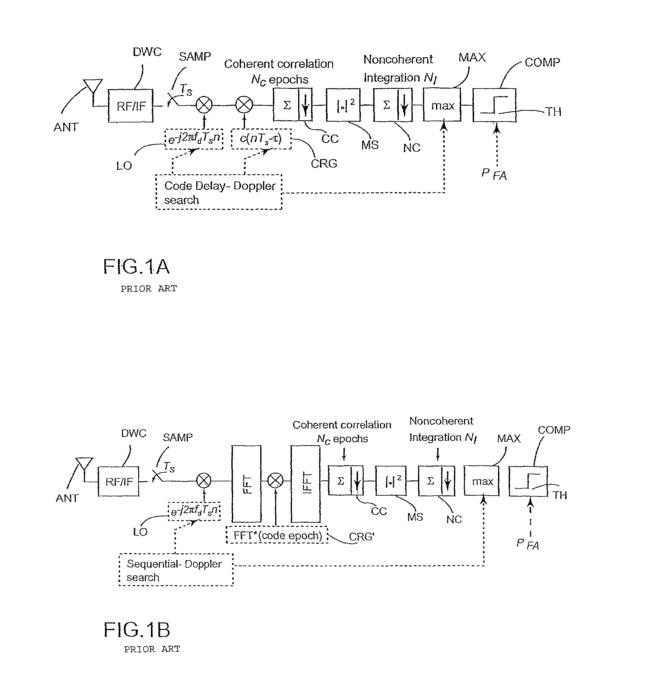
[0146]A third embodiment, reducing the computational burden on the Signal Processing Unit will now be described with reference to FIG. 9. This embodiment is not suitable to “stand alone” operation, since it relies on assistance information coming from a nearby, terrestrial Location Server. Moreover, this assistance information has to comprise, beside a list of in-view satellite emitters, a list of the code delays for said satellite emitters (or at least of the differences in code delay between the emitters).

[0147]The third embodiment of the invention comprises using the method of the first or second embodiment until a “reference” near-far free satellite emitter is acquired and recognized as such. From that point on, the much simpler method of FIG. 9 can be used.

[0148]At step 90, assistance information is used to determine a comparatively narrow set of trial code delay values: in fact, the difference between the code delay of a given satellite emitter and that of the “reference” sate...


PUM


Abstract

A method of processing positioning signal constituted by a superposition of individual signals generated by a plurality of emitters, in particular satellite emitters, comprising:—a first step of coarse acquisition of said individual signals, comprising correlation of the received positioning signal with locally generated replicas of said individual signals;—a step of identifying spurious correlation peaks induced by interferences; and—a step of estimating the code delays and the carrier frequency shifts of the acquired individual signals which are not affected by said interferences. According to preferred embodiments of the invention, the method can also comprise:—a refining step of determining more accurate estimates of said code delays and carrier frequency shifts; and—a step of interference cancellation. The method of the invention is particularly suitable to indoor positioning applications.

Description

[0001]The invention relates to a method of processing a set of spread-spectrum positioning signals, and in particular a Global Navigation Satellite System (GNSS) signal, such as a GPS, Glonass or Galileo signal. The method of the invention is particularly suitable to urban and indoor positioning applications.BACKGROUND OF THE INVENTION[0002]Global Navigation Satellite Systems are systems allowing a receiver, located anywhere on or in the vicinity of the Earth, to compute its position by means of the signals broadcasted by synchronized satellite emitters. Examples of such systems are the Global Positioning System (GPS) [Kaplan, 1996], Glonass and Galileo [Hein, 2000]. A GNSS comprises a plurality of satellite emitters generating direct-sequence code-modulated signals [Utlaut, 1978], i.e. the code (taking values +1 and −1, or any other discrete set of values) multiplies the original signal. Therefore, a GNSS positioning signal is generally constituted by a superposition of individual ...

Claims


Application Information

Patent Timeline
Patent Type & Authority Patents(United States)
IPC IPC(8): H04B1/00
CPCG01C21/206G01S5/0221G01S19/21
Inventor LOPEZ-RISUENO, GUSTAVOGRANADOS, GONZALO SECO
Owner EUROPEAN SPACE AGENCY
Learn More