Scanning non-scanning LIDAR

a non-scanning, lidar technology, applied in the direction of distance measurement, instruments, surveying and navigation, etc., can solve the problems of limiting the use of human visual imaging as a way to determine terrain features, limiting the use of real-time terrain maps, and severe limitations on pilot's situational awareness (sa)

Active Publication Date: 2014-02-25
RD2 LLC
View PDF7 Cites 49 Cited by
  • Summary
  • Abstract
  • Description
  • Claims
  • Application Information

AI Technical Summary

Problems solved by technology

Low or no visibility situations, sometimes called degraded usable cue environments (DUCE), can severely limit a pilot's
The presence of obscurants such as dust, sand, snow, etc. beneath the aircraft limits the use of human visual imaging as a way to determine terrain features.
Existing systems, however, suffer from drawbacks that limit their use for producing such a real time terrain map.
Traditional radar based scanning systems are limited in resolution of terrain features as well as maximum scan angle capability.
Radar sensors are also susceptible to specular reflections from several natural materials, which can further diminish the terrain resolution.
Furthermore, at large scan angles, the main lobe of the radar signal widens resulting in a large RF footprint on the ground.
This limits the ability of the aircraft to operate covertly.
This however comes at the expense of a large aperture size.
In general, both radar and MMW systems have size, weight, and power draw requirements that are not ideally suited for helicopter applications.
However, this concept only works for well-defined phase differences between the individual beams in the array.
Introduction of phase error can significantly reduce the on-axis optical power and degrade the resolution of the measurement.
For this reason, this technique is not recommended for applications involving vibrating platforms.
While considerable work has been done in this area towards improving the speed, scan angle, and intrinsic stability of MEMS devices, the insertion loss and power handling capability of such devices requires further improvement prior to use in high power LIDAR applications.
Acousto-optic devices are fast, but suffer from low efficiency and produce an unwanted zero-order diffraction beam.
Existing techniques are not capable of meeting the size, weight, power draw, vibration, shock, update rate, and other essential harsh environmental requirements of a helicopter platform.

Method used


Image

  • Scanning non-scanning LIDAR
  • Scanning non-scanning LIDAR
  • Scanning non-scanning LIDAR

Examples


Embodiment Construction

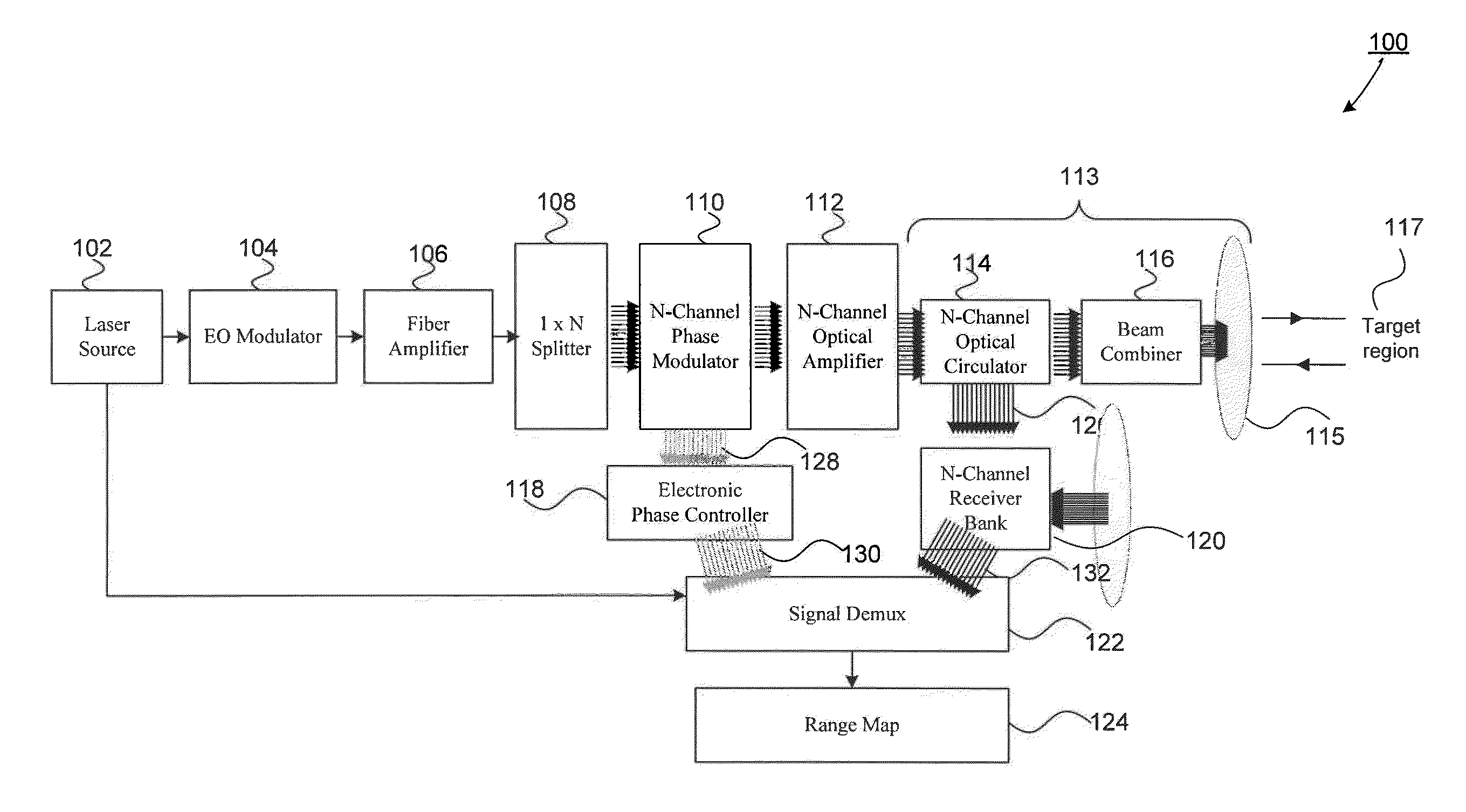
[0028]This specification discloses one or more embodiments that incorporate the features of this invention. The disclosed embodiment(s) merely exemplify the invention. The scope of the invention is not limited to the disclosed embodiment(s). The invention is defined by the claims appended hereto.

[0029]The embodiment(s) described, and references in the specification to “one embodiment,”“an embodiment,”“an example embodiment,” etc., indicate that the embodiment(s) described may include a particular feature, structure, or characteristic, but every embodiment may not necessarily include the particular feature, structure, or characteristic. Moreover, such phrases are not necessarily referring to the same embodiment. Further, when a particular feature, structure, or characteristic is described in connection with an embodiment, it is understood that it is within the knowledge of one skilled in the art to effect such feature, structure, or characteristic in connection with other embodiments...


PUM


Abstract

An all fiber optic laser based scanning system for real time terrain mapping under degraded visual conditions is disclosed. A laser output is modulated to achieve a desired pulse width and pulse repetition frequency (PRF) and the modulated signal is amplified. The amplified optical signals are split into N channels that correspond to N elements of an optically phased array that steers light by modulating the phase of light entering and exiting the optical system. By applying a linear phase shift across the beam's wave front, the light propagating along the system's optical axis is steered to an off-axis angle. A real time map of an underlying terrain is accomplished by sweeping the N channel array across the terrain while collecting range information from each scan grid.

Description

CROSS REFERENCE TO RELATED APPLICATIONS[0001]This application claims benefit under 35 U.S.C. §119(e) to U.S. Provisional Patent Application No. 61 / 443,021, filed Feb. 15, 2011, which is incorporated by reference herein in its entirety.BACKGROUND[0002]1. Field of the Invention[0003]This disclosure relates to a system and method that provides an airborne vehicle operator environmental condition information to assist in operating the airborne vehicle in less than optimal visibility situations.[0004]2. Background Art[0005]Low or no visibility situations, sometimes called degraded usable cue environments (DUCE), can severely limit a pilot's<situational awareness (SA) during take-off and landing operations. The presence of obscurants such as dust, sand, snow, etc. beneath the aircraft limits the use of human visual imaging as a way to determine terrain features. Ensuring the utmost safety under these conditions requires a detailed real time terrain map indicating ground features such a...

Claims


Application Information

Patent Timeline
Patent Type & Authority Patents(United States)
IPC IPC(8): G01B9/02G01C3/08
CPCG01S7/4814G01S17/89G01S17/10G01S7/4818
Inventor DAKIN, ELIZABETH A.MAMIDIPUDI, PRIYAVADANROGERS, PHILIP L.CHANGKAKOTI, RUPAKDAKIN, DANIEL C.
Owner RD2 LLC
Why Eureka
Try Eureka