Method for implementing navigation by photograph based on mobile phone

A photo and mobile phone technology, applied in the field of navigation, can solve problems such as troublesome search, difficult search, inaccurate destination text memory, etc., and achieve the effect of improving efficiency and accuracy

Inactive Publication Date: 2008-12-10
杨爱国 +1
View PDF0 Cites 39 Cited by
  • Summary
  • Abstract
  • Description
  • Claims
  • Application Information

AI Technical Summary

Problems solved by technology

Although this kind of navigation method can support dynamic navigation, there are following disadvantages in this kind of navigation method: the one, must carry out communication with mobile gateway through communication module, has increased intermediate link (promptly through navigation center) and makes operation change complicated; Telephone voice confirmation may result in higher communication costs; thir

Method used


Image

  • Method for implementing navigation by photograph based on mobile phone
  • Method for implementing navigation by photograph based on mobile phone

Examples


Embodiment 1

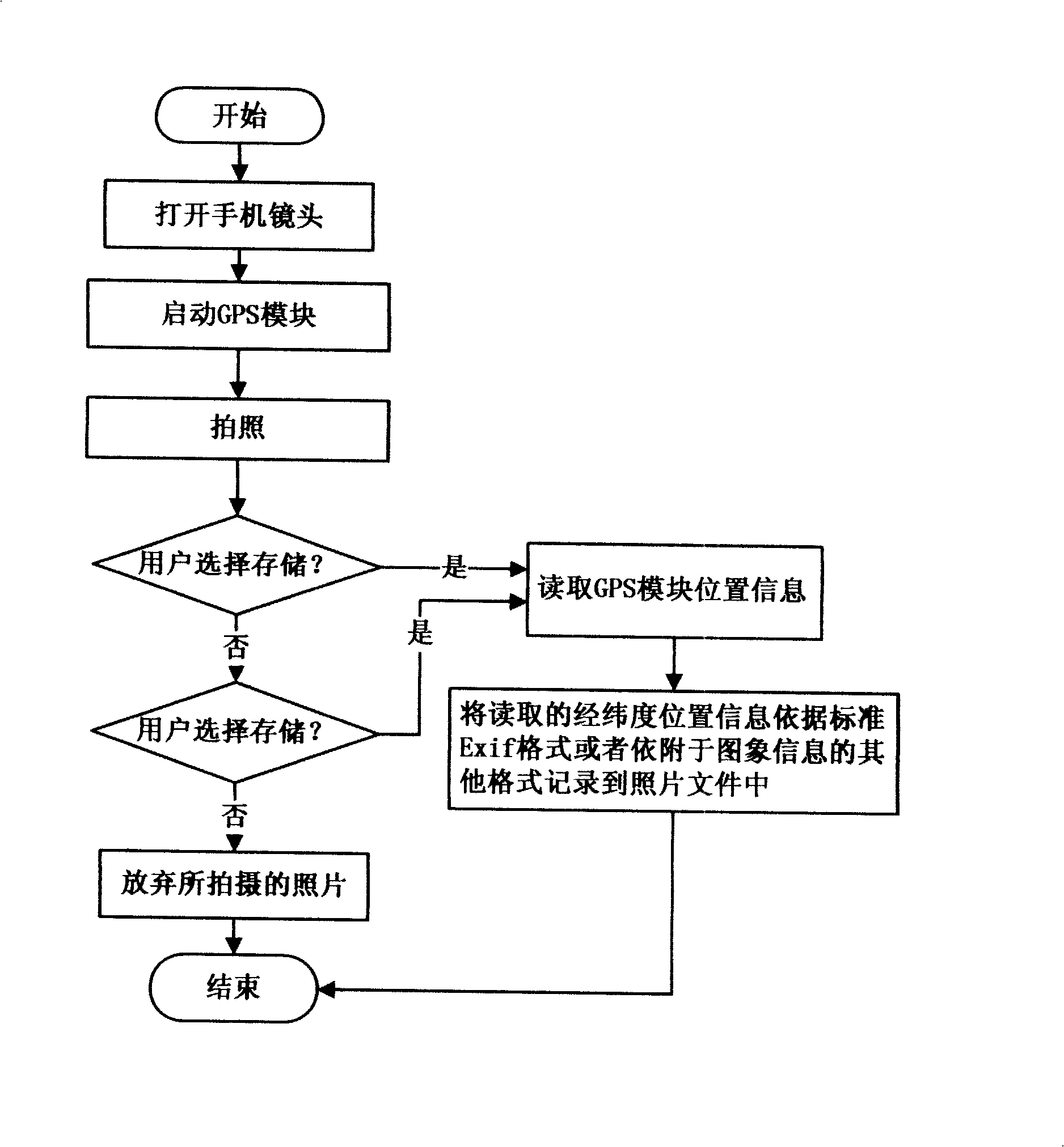
[0023] User A stays in a hotel on a business trip, and before he drives out to do errands, follow the steps below:

[0024] Step 1: Start the camera function of the mobile phone, and the mobile phone automatically activates the GPS positioning function;

[0025] Step 2: when taking a picture, the camera module invokes the location information storage module to record the location information when taking a photo on the photo file with the standard Exif format or other formats attached to the image information, thereby realizing the association of the photo and the latitude and longitude location information;

[0026] Step 3: store the photo together with the position information recorded in the photo file in the standard Exif format or other formats attached to the image information as a standard photo file on the mobile phone storage medium (FLASH, SD, etc. class storage media). The file name can be automatically generated, and the user can modify the photo file name, such as...

Embodiment 2

[0032] When user A needs to find user B, and user A does not know the location of user B, user B can perform the following operations:

[0033] Step 1: User B activates the mobile phone camera function, and the mobile phone automatically activates the GPS positioning function;

[0034] Step 2: when taking a picture, the camera module invokes the location information storage module to record the location information when taking a photo on the photo file with the standard Exif format or other formats attached to the image information, thereby realizing the association of the photo and the user B's location information;

[0035] Step 3: the photo is stored on the mobile phone storage medium as a standard photo file together with the location information of the user B recorded in the photo in the standard Exif format or other formats attached to the image information (the FLASH that the mobile phone is equipped with or the user purchases separately, SD and other storage media). T...

Embodiment 3

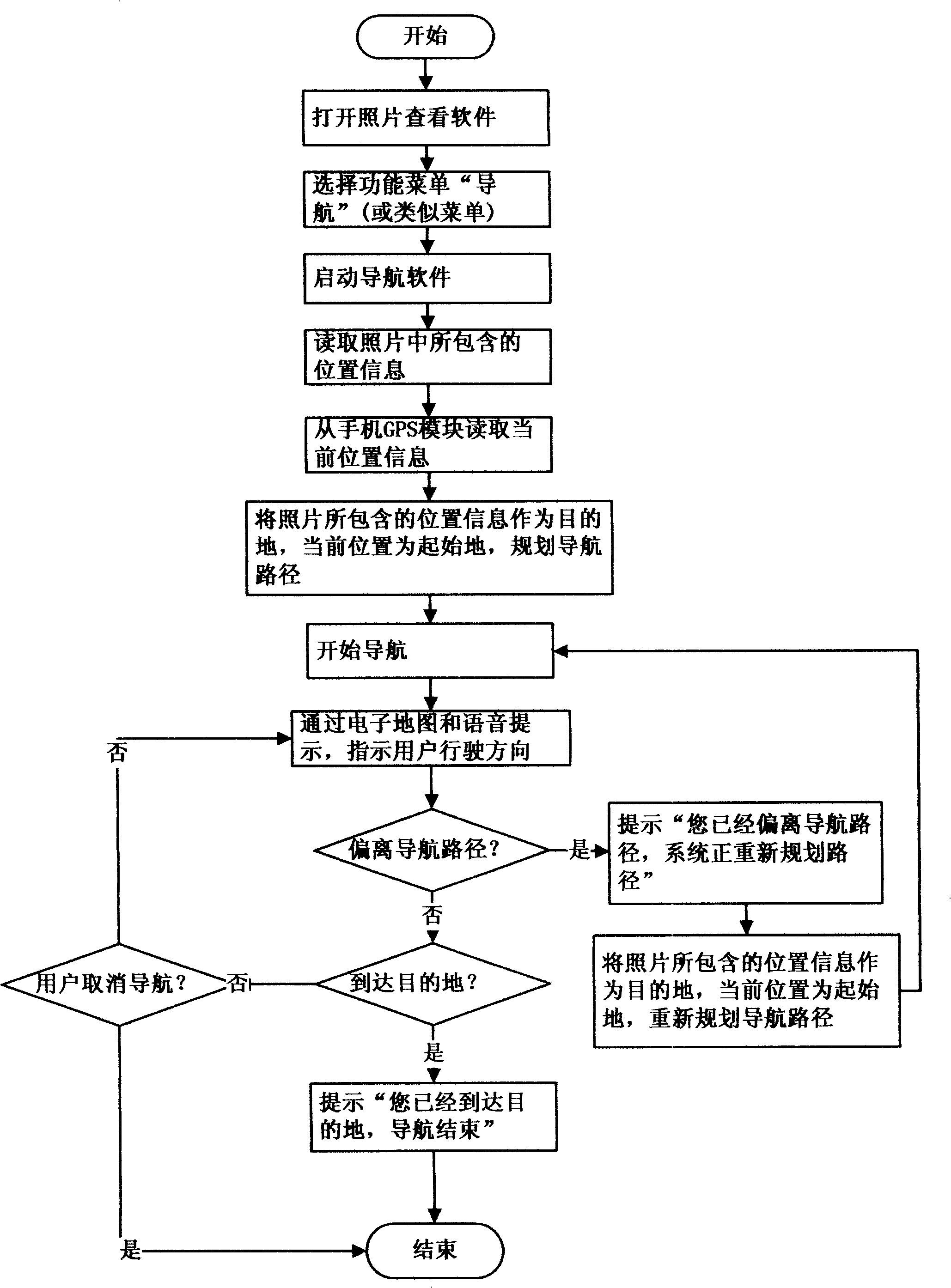
[0041] User A’s mobile phone just stores a photo with GPS location information uploaded or downloaded to the mobile phone through a digital camera or computer in the early stage, and the location of this location information is exactly the destination to be navigated, then user A operates according to the following steps :

[0042] Step 1: Start the mobile phone photo viewing software, move to the corresponding photo, select "Navigation" (or similar menu) in the function menu, and the reading software that reads the latitude and longitude position information on the photo in the navigation system starts to read in standard Exif format Or the longitude and latitude position information recorded in the photo file in other formats attached to the image information;

[0043] Step 2: The navigation system matches the input parameters of the read longitude and latitude position information to the electronic map, and uses this point as the navigation destination;

[0044] Step 3: Th...


PUM


Abstract

The invention provides a method for navigation by using a photo based by a mobile phone. The photo used for navigation can be obtained by using the mobile phone to shoot, can be wirelessly transmitted by other people, uploaded by a digital camera or a computer or downloaded from the internet to the mobile phone. When the method of the invention is realized, a navigation destination is confirmed by the position information recorded on a photo file by a standard Exif format or other formats attached on image information. When the method of the invention is carried out, besides based on the existing mobile phone system modules which comprises a mobile phone functional module, a GPS module, a GSM/GPRS/CDMA or other communicating modules as well as an imaging module, a storage software module for storing GPS position information and a reading software module for reading the GPR position information are newly added if the photo obtained by using the mobile phone to shoot is used for navigation; the reading software module for reading the GPR position information is only needed to be added if the photo wirelessly transmitted by other people, uploaded by a digital camera or a computer or downloaded from the internet is used for navigation.

Description

technical field [0001] The invention relates to navigation technology, in particular to a method for realizing navigation based on mobile phone photos. technical background [0002] As a convenient communication tool, after years of development, the mobile phone has developed from simply answering the phone at the beginning to sending and receiving short messages, wireless data transmission, MMC (Multimedia Memory Card), infrared, Bluetooth, camera, navigation and other functions. To meet the needs of different groups of people for mobile phone functions. Up to now, there are mainly two kinds of navigation methods based on mobile phones at home and abroad. One is the center navigation method. The navigation mobile phone using this method contains a GPS (Global Positioning System, Global Positioning System, the same below) receiver. When the navigation service is needed, the user will notify the destination name through the mobile phone or send the destination name to The n...

Claims


Application Information

Patent Timeline
IPC IPC(8): G01C21/00G01C21/30G01C11/00
Inventor 杨爱国陈典全
Owner 杨爱国
Why Eureka
Try Eureka