Evaluation system for damage of urban underground gas ductwork caused by geological calamity
A technology of geological hazards and assessment systems, applied in the field of assessment systems, can solve problems such as the combination of urban geological hazards and pipeline risk assessment, and the inability of the risk assessment system to assess geological conditions
- Summary
- Abstract
- Description
- Claims
- Application Information
AI Technical Summary
Problems solved by technology
Method used
Image
Examples
specific Embodiment approach 1
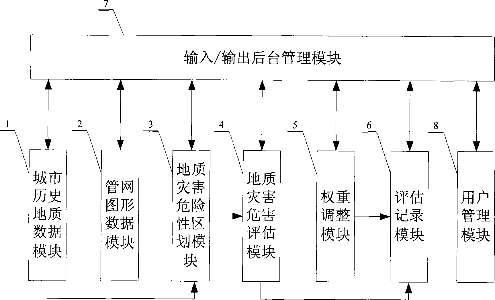
[0018] Specific implementation mode 1: The assessment system of geological hazards in this implementation mode on the urban underground gas pipeline network includes the following units:
[0019] Urban historical geological data module 1, which is used to query and modify the geological disaster types and urban historical geological data information of cities given by the system; it is also used to edit the geological disaster types and urban historical geological data information of cities not given by the system; urban geological data Including: urban groundwater level, annual precipitation, soil type and location in seismic zone. The types of urban geological hazards include: earthquakes, ground subsidence and subsidence, debris flows and sand liquefaction.
[0020] Pipe network graphic data module 2, used to query the graphic data, properties of the gas pipeline network, partition settings and partition evaluation records of the underground gas pipeline network of the city...
specific Embodiment approach 2
[0044] Embodiment 2: The difference between this embodiment and the evaluation system of geological disasters causing harm to the urban underground gas pipeline network described in Embodiment 1 is that it also includes a user management module 8, which is used for Modify the password, add users, initialize the data of geological data module 1, pipe network graphic data module 2, geological hazard hazard zoning module 3, geological hazard hazard assessment module 4, weight adjustment module 5 and evaluation record module 6.
specific Embodiment approach 3
[0045] Embodiment 3: This embodiment uses the system of Embodiment 2 with specific parameters to illustrate the present invention: taking Harbin urban area as an example, the hazard of debris flow in Harbin urban area is assessed.
[0046] Input the urban historical geological data and disaster types of Harbin into the urban historical geological data module 1:
[0047] Urban geological data: average temperature: 5°C; maximum temperature: 38.7°C; minimum temperature: -35°C; maximum permafrost depth: 1.9m; average precipitation: 550mm; single-day maximum precipitation: 168mm; groundwater level: 3m; Fault zone: none; soil type: yellow clay; seismic zone: none; geological features: plain area; geological acceleration value: 0.15g;
[0048] Types of urban historical geological disasters: name of geological disasters: mudslides; occurrence times: 5; occurrence area: southwest of the city; latest occurrence time: within 1 year; latest occurrence scale: 2.4*10 4 m 3 ;The time of ...
PUM
 Abstract
Description
Claims
Application Information
 - R&D
- Intellectual Property
- Life Sciences
- Materials
- Tech Scout
- Unparalleled Data Quality
- Higher Quality Content
- 60% Fewer Hallucinations
Browse by: Latest US Patents, China's latest patents, Technical Efficacy Thesaurus, Application Domain, Technology Topic, Popular Technical Reports.
© 2025 PatSnap. All rights reserved.Legal|Privacy policy|Modern Slavery Act Transparency Statement|Sitemap|About US| Contact US: help@patsnap.com

